We're combining a few of our favourite hikes to complete the 17km Sheldon Lake loop in Queen Elizabeth II Wildlands Provincial Park. We'll take in Sheldon Lake, Scrabble Mountain (spots you might be familiar with from previous hikes) over an incredibly diverse hike.
This trip is a real adventure and a challenge for those who wanted to push a little harder.
Because this trip is more challenging, it's particularly important that you read this trip plan carefully and bring those things outlined!
You might be looking at the distance and elevation thinking this isn't too bad but that would be a mistake. With the constant changes in elevation and snow on the ground, this will be a real challenge. There's a small rock face you'll need to descend at one point and plenty of beaver dams that require good balance to traverse. Further adding to the difficulty will be unpredictable weather conditions and the race against time to complete the hike before sundown.
We'll be aiming for a pace of 3km/hr to ensure that we're out before sundown.

06:20 - Meet at the PetroCanada at Keele Station. We need to make an early start so we won't be able to stop for breakfast en route. Please pack your lunch and get a breakfast/coffee in before you join us!
06:30 - Shuttle leaves from PetroCanada at Keele Station. Please note that we leave dead on 6:30am and can't wait for latecomers.
09:00 - Meet self-drivers at the trailhead. If there are no spaces here, park up at the Devil's Lake lot further up the road. Do not be late! Fair warning, the van may end up being a few minutes late but self-drivers shouldn't come later than the van or they won't be able to join the hike.
Hike, eating lunch en route
16:30 - Anticipated return to car
19:00 - Approx return time to Keele Subway Station
This custom map is georeferenced, meaning it will show you where you are on the map in the right software and lays out the rough path that we’ll be following. It’s opened with the Avenza app which must be downloaded and installed in advance of the adventure.
You should also download the What3words app - this makes it easy to share and find locations in the unlikely event that you get lost.
Keep an eye on how the weather is developing here
Blaze orange clothing - It's hunting season so it's important that we're all visible. You'll need to be wearing something bright orange - think a high vis jacket (a yellow one is ok), an orange baseball cap etc. Dollarama and Canadian Tire will be a good source of affordably priced options.
A head torch - In case we end up out after dark. Unlikely but we should be prepared.
Ice spikes/cleats - There will be snow or ice on the ground. If you can't bring your own, make sure you request some!
Hot drink/Handwarmers - It'll be nice to have this if it gets cold (currently looking unlikely)
A rain jacket - Looks like we'll have a bit of rain
Layered clothing - No denim, no cotton! Our IG video should give you a good sense of what to bring. Do not bring a heavy winter coat
Hiking boots/shoes with good grip - Running shoes are not suitable for this hike
A spare pair of socks
You may wish to bring hiking poles
At least 1.5L of water
A packed lunch and snacks
If you requested it, we'll pack a pair of ice spikes for you. We use these a lot and it's worth purchasing some of your own. We recommend Kahtoola Exospikes or any of the Amazon rip-offs if you're on a budget!
Hunting - It is hunting season and there are active hunters in this park. While I don't anticipate coming across many, it's important that we're dressed in bright colours to avoid any accidents.
Getting lost - This is a wilderness location, away from help so it's imperative that we stay together at all times. If you get separated from the group, stop and call for help. It's unlikely that you'll have reception during this adventure. YOU MUST STAY WITH THE GROUP AT ALL TIMES. No breaking off without first discussing it with the hike leader!
Hiking injuries - Wear appropriate footwear and hike within your abilities. If you need extra support, bring hiking poles. Any injuries? Let us know in advance of the hike.
We like to share some of the indigenous background of the areas we visit because these territories have rich histories that are easy to overlook. Indigenous communities have a connection to and respect for the land that has largely been lost since European settlement. As we strive to form a deeper connection with the land, we have much to learn from these communities. I use the Native Land map to learn more about these areas and find that developing a richer understanding leads to a greater enjoyment of the adventures.
The park is located on the traditional territories of the Missisaugas of the Credit First Nation the Anishnabe and the Huron Wendat.
We're combining a few of our favourite hikes to complete the 17km Sheldon Lake loop in Queen Elizabeth II Wildlands Provincial Park. We'll take in Sheldon Lake, Scrabble Mountain (spots you might be familiar with from previous hikes) over an incredibly diverse hike.
This trip is a real adventure and a challenge for those who wanted to push a little harder.
Because this trip is more challenging, it's particularly important that you read this trip plan carefully and bring those things outlined!
You might be looking at the distance and elevation thinking this isn't too bad but that would be a mistake. With the constant changes in elevation and snow on the ground, this will be a real challenge. There's a small rock face you'll need to descend at one point and plenty of beaver dams that require good balance to traverse. Further adding to the difficulty will be unpredictable weather conditions and the race against time to complete the hike before sundown.
We'll be aiming for a pace of 3km/hr to ensure that we're out before sundown.
06:20 - Meet at the PetroCanada at Keele Station. We need to make an early start so we won't be able to stop for breakfast en route. Please pack your lunch and get a breakfast/coffee in before you join us!
06:30 - Shuttle leaves from PetroCanada at Keele Station. Please note that we leave dead on 6:30am and can't wait for latecomers.
09:00 - Meet self-drivers at the trailhead. If there are no spaces here, park up at the Devil's Lake lot further up the road. Do not be late! Fair warning, the van may end up being a few minutes late but self-drivers shouldn't come later than the van or they won't be able to join the hike.
Hike, eating lunch en route
16:30 - Anticipated return to car
19:00 - Approx return time to Keele Subway Station
This custom map is georeferenced, meaning it will show you where you are on the map in the right software and lays out the rough path that we’ll be following. It’s opened with the Avenza app which must be downloaded and installed in advance of the adventure.
You should also download the What3words app - this makes it easy to share and find locations in the unlikely event that you get lost.
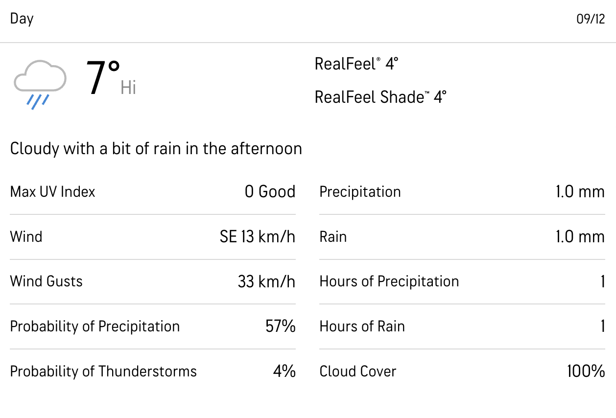
Keep an eye on how the weather is developing here
Keep an eye on how the weather is developing here
Blaze orange clothing - It's hunting season so it's important that we're all visible. You'll need to be wearing something bright orange - think a high vis jacket (a yellow one is ok), an orange baseball cap etc. Dollarama and Canadian Tire will be a good source of affordably priced options.
A head torch - In case we end up out after dark. Unlikely but we should be prepared.
Ice spikes/cleats - There will be snow or ice on the ground. If you can't bring your own, make sure you request some!
Hot drink/Handwarmers - It'll be nice to have this if it gets cold (currently looking unlikely)
A rain jacket - Looks like we'll have a bit of rain
Layered clothing - No denim, no cotton! Our IG video should give you a good sense of what to bring. Do not bring a heavy winter coat
Hiking boots/shoes with good grip - Running shoes are not suitable for this hike
A spare pair of socks
You may wish to bring hiking poles
At least 1.5L of water
A packed lunch and snacks
If you requested it, we'll pack a pair of ice spikes for you. We use these a lot and it's worth purchasing some of your own. We recommend Kahtoola Exospikes or any of the Amazon rip-offs if you're on a budget!
Hunting - It is hunting season and there are active hunters in this park. While I don't anticipate coming across many, it's important that we're dressed in bright colours to avoid any accidents.
Getting lost - This is a wilderness location, away from help so it's imperative that we stay together at all times. If you get separated from the group, stop and call for help. It's unlikely that you'll have reception during this adventure. YOU MUST STAY WITH THE GROUP AT ALL TIMES. No breaking off without first discussing it with the hike leader!
Hiking injuries - Wear appropriate footwear and hike within your abilities. If you need extra support, bring hiking poles. Any injuries? Let us know in advance of the hike.
We like to share some of the indigenous background of the areas we visit because these territories have rich histories that are easy to overlook. Indigenous communities have a connection to and respect for the land that has largely been lost since European settlement. As we strive to form a deeper connection with the land, we have much to learn from these communities. I use the Native Land map to learn more about these areas and find that developing a richer understanding leads to a greater enjoyment of the adventures.
The park is located on the traditional territories of the Missisaugas of the Credit First Nation the Anishnabe and the Huron Wendat.
