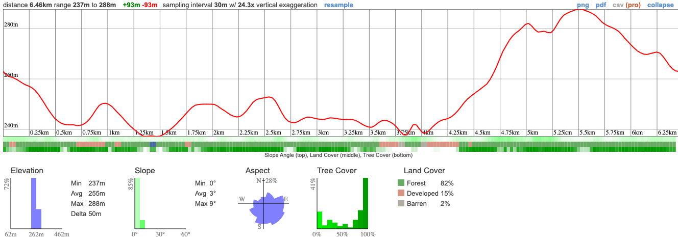
The Kawartha Highlands is the second largest park in Southern Ontario. We'll begin just at the northern part of it where the 9 KM loop will take us through meadows, forests and rocky outcrops. This trail is also interactive - keep your phone batteries full so you can scan the QR codes along the trail to learn more about the beautiful nature we pass.
To cool off, we'll stop by the busy waters of Burleigh Falls. There's no actual trail, but feel free to safely walk across as far as the large boulders will take you. You can dip your hands, feet, or if you're feeling adventurous, your head into the cold rushing water.
%20(1).jpeg)
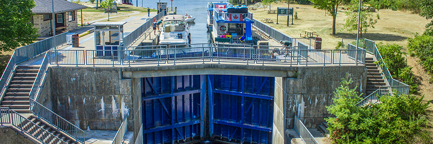
We'll walk across the street to Trent-Severn Waterway Lock #28. We may catch a glimpse of how Lock #28 lowers and raises large boats and other watercraft between each stretches of water.
We'll be making two pickups and drop offs for this adventure so it should be really easy to join. Make sure you tell us in the group chat where you want picking up!
Hike Length: 9km
Terrain: An easy hike through some beautiful wilderness. We'll be on rock and dirt trails
Estimated time to complete: 5 hours with breaks and exploration time.
07:50: Those leaving from Keele arrive at the PetroCanada by Keele Subway Station
08:00: Shuttle leaves
08:15: Second pick up outside the front of Union Station. We're in the red van, directly outside the front of the Station on Front Street and opposite the Fairmont Hotel.
10:15: Arrive at car park and trail head
10:30: Begin hike, eating lunch en route
14:00: Wrap up hike and arrive back at trail head
14:00 - 15:30: Relax at Burleigh Falls
15:30: Head back to Toronto
18:00: Anticipated return to Union Station
18:15: Anticipate return to Keele Station
This custom map is georeferenced, meaning it will show you where you are on the map in the right software and lays out the rough path that we’ll be following. It’s opened with the Avenza app which must be downloaded and installed in advance of the adventure.
You should also download the What3words app - this makes it easy to share and find locations in the unlikely event that you get lost.
I'm not 100% if there'll be safe place to swim but you might want to pack stuff just in case!
Remember to pack a lunch, some snacks and at least 1l of water.
Hiking injuries - Wear appropriate footwear and hike within your abilities. If you need extra support, bring hiking poles.
Sunburn/heat stroke/dehydration - Wear sunscreen and a sun hat. Make sure that you hydrate regularly
Ticks - Black legged ticks are present in the area. You should wear pants rather than shorts to prevent them latching on and lighter colours make it easier to spot them and keep you more cool. There's no need to worry about ticks if we take a few precautions and we'll talk about doing a tick check after the hike just to confirm we haven't picked any up. You can learn more here
Drowning - If you can't swim you should keep away from the river
We like to share some of the indigenous background of the areas we visit because these territories have rich histories that are easy to overlook. Indigenous communities have a connection to and respect for the land that has largely been lost since European settlement. As we strive to form a deeper connection with the land, we have much to learn from these communities. I use the Native Land map to learn more about these areas and find that developing a richer understanding leads to a greater enjoyment of the adventures.
We'll be at the edge of the Kawarth Highlands, in the traditional territory the Anishnabe, the Mississauga nation and the Huron Wendat.
The Kawartha Highlands is the second largest park in Southern Ontario. We'll begin just at the northern part of it where the 9 KM loop will take us through meadows, forests and rocky outcrops. This trail is also interactive - keep your phone batteries full so you can scan the QR codes along the trail to learn more about the beautiful nature we pass.
To cool off, we'll stop by the busy waters of Burleigh Falls. There's no actual trail, but feel free to safely walk across as far as the large boulders will take you. You can dip your hands, feet, or if you're feeling adventurous, your head into the cold rushing water.
We'll walk across the street to Trent-Severn Waterway Lock #28. We may catch a glimpse of how Lock #28 lowers and raises large boats and other watercraft between each stretches of water.
We'll be making two pickups and drop offs for this adventure so it should be really easy to join. Make sure you tell us in the group chat where you want picking up!
Hike Length: 9km
Terrain: An easy hike through some beautiful wilderness. We'll be on rock and dirt trails
Estimated time to complete: 5 hours with breaks and exploration time.
07:50: Those leaving from Keele arrive at the PetroCanada by Keele Subway Station
08:00: Shuttle leaves
08:15: Second pick up outside the front of Union Station. We're in the red van, directly outside the front of the Station on Front Street and opposite the Fairmont Hotel.
10:15: Arrive at car park and trail head
10:30: Begin hike, eating lunch en route
14:00: Wrap up hike and arrive back at trail head
14:00 - 15:30: Relax at Burleigh Falls
15:30: Head back to Toronto
18:00: Anticipated return to Union Station
18:15: Anticipate return to Keele Station
This custom map is georeferenced, meaning it will show you where you are on the map in the right software and lays out the rough path that we’ll be following. It’s opened with the Avenza app which must be downloaded and installed in advance of the adventure.
You should also download the What3words app - this makes it easy to share and find locations in the unlikely event that you get lost.
I'm not 100% if there'll be safe place to swim but you might want to pack stuff just in case!
Remember to pack a lunch, some snacks and at least 1l of water.
Hiking injuries - Wear appropriate footwear and hike within your abilities. If you need extra support, bring hiking poles.
Sunburn/heat stroke/dehydration - Wear sunscreen and a sun hat. Make sure that you hydrate regularly
Ticks - Black legged ticks are present in the area. You should wear pants rather than shorts to prevent them latching on and lighter colours make it easier to spot them and keep you more cool. There's no need to worry about ticks if we take a few precautions and we'll talk about doing a tick check after the hike just to confirm we haven't picked any up. You can learn more here
Drowning - If you can't swim you should keep away from the river
We like to share some of the indigenous background of the areas we visit because these territories have rich histories that are easy to overlook. Indigenous communities have a connection to and respect for the land that has largely been lost since European settlement. As we strive to form a deeper connection with the land, we have much to learn from these communities. I use the Native Land map to learn more about these areas and find that developing a richer understanding leads to a greater enjoyment of the adventures.
We'll be at the edge of the Kawarth Highlands, in the traditional territory the Anishnabe, the Mississauga nation and the Huron Wendat.