We have some spots that are so special that we feel an obligation to keep them off the public's radar. We've spent months poring over maps and scouting out locations that sometimes very few other people have visited. WU is the circle of trust where we share these places on the understanding that we keep them between members so they stay special and most importantly, protected. We take this seriously and ask that you don't share the location outside of our community or on social media.
Our first stop Saturday is the Cooper's Falls trail in Kahshe Barrens. It's part of the trans-Canada trail system and therefore not a complete secret but for some reason, it hasn't yet become more popular hence keeping it under the cone of silence! It's some of the closest true wilderness on the Canadian Shield to Toronto, making it a pretty special place. You can expect a beautiful, challenging hike without coming across many people throughout the day.
The Shield has some of the oldest exposed rock on earth at about 3 billion years old. The barrens we're visiting are an ecosystem typical of the area and characterized by sparse vegetation, shallow soil layers, and exposed rock surfaces.
It's a wild walk and you can expect to get muddy.
Once we're done with the hike, we're driving up the road for the mystery adventure portion of the day... visiting the Tree Museum of Gravenhurst. This is a unique site with art works scattered among the forest. We'll walk in another km or so to find what's hidden there.
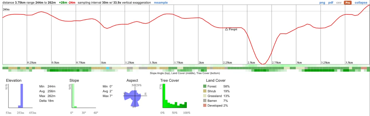
Hike Length: 7.5km
Terrain: This is an extremely varied hike and we'll be walking across exposed granite, boardwalks, beaver flooded trails, forest and more. At times, there are some steep climbs that we'll take a little more slowly.
Estimated time to complete: 4 hours with breaks and exploration time.
08:20 - Meet at PetroCanada next to Keele Subway Station. There's free parking on Keele Street north of the station. Make sure you've had breakfast and used the washroom before meeting us!
08:30 - Van leaves. Please note that we'll be leaving dead on time and can't wait for latecomers so please, please be on time!
10:15 - Meet self drivers at the trail head. Self drivers - ensure that you're on time and at the right location at Housey Rapids Road.
10:15 - Begin hike, eating lunch en route
14:00 - End hike. Drive up to tree museum
16:00 - Begin return to Toronto.
18:00 - Rough arrival time back at Keele Station
This custom map is georeferenced, meaning it will show you where you are on the map in the right software and lays out the rough path that we’ll be following. It’s opened with the Avenza app which must be downloaded and installed in advance of the adventure.
You should also download the What3words app - this makes it easy to share and find locations in the unlikely event that you get lost.
General Notes
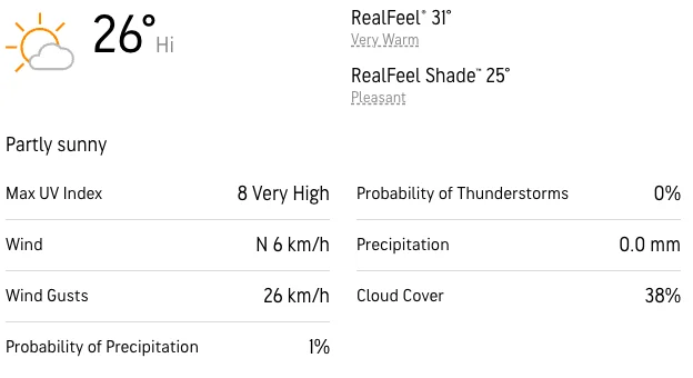
It's going to be very hot and this route involves areas that are sometimes flooded by beavers so dressing for the weather and preparing for wet feet is important!
Packing list
Have any questions? Ask us on the Discord! Members who turn up dressed in a way that puts themselves at risk will not be able to join us.
Heat Exhaustion/Sun Exposure - It's a very hot day with heat exhaustion and sunburn a real possibility. Follow these steps to protect yourself:
Getting lost - This is a wilderness location, away from help so it's imperative that we stay together at all times. If you get separated from the group, stop and call for help. It's unlikely that you'll have reception during this adventure. YOU MUST STAY WITH THE GROUP AT ALL TIMES. No breaking off without first discussing it with the hike leader!
Hiking injuries - Wear appropriate footwear and hike within your abilities. If you need extra support, bring hiking poles. Any injuries? Let us know in advance of the hike.
Ticks - Black legged ticks are in the area. You should wear pants rather than shorts to prevent them latching on and lighter colours make it easier to spot them and keep you more cool. There's no need to worry about ticks if we take a few precautions and we'll talk about doing a tick check after the hike just to confirm we haven't picked any up. You can learn more here.
Wild animals - Stay back from any wild animals that you come across. Your guide will give you further instructions.
We like to share some of the indigenous background of the areas we visit because these territories have rich histories that are easy to overlook. Indigenous communities have a connection to and respect for the land that has largely been lost since European settlement. As we strive to form a deeper connection with the land, we have much to learn from these communities. I use the Native Land map to learn more about these areas and find that developing a richer understanding leads to a greater enjoyment of the adventures.
Cooper's Falls and the surrounding area is on the traditional territory of the Huron Wendat, Anishnabek and Mississauga Nations
We have some spots that are so special that we feel an obligation to keep them off the public's radar. We've spent months poring over maps and scouting out locations that sometimes very few other people have visited. WU is the circle of trust where we share these places on the understanding that we keep them between members so they stay special and most importantly, protected. We take this seriously and ask that you don't share the location outside of our community or on social media.
Our first stop Saturday is the Cooper's Falls trail in Kahshe Barrens. It's part of the trans-Canada trail system and therefore not a complete secret but for some reason, it hasn't yet become more popular hence keeping it under the cone of silence! It's some of the closest true wilderness on the Canadian Shield to Toronto, making it a pretty special place. You can expect a beautiful, challenging hike without coming across many people throughout the day.
The Shield has some of the oldest exposed rock on earth at about 3 billion years old. The barrens we're visiting are an ecosystem typical of the area and characterized by sparse vegetation, shallow soil layers, and exposed rock surfaces.
It's a wild walk and you can expect to get muddy.
Once we're done with the hike, we're driving up the road for the mystery adventure portion of the day... visiting the Tree Museum of Gravenhurst. This is a unique site with art works scattered among the forest. We'll walk in another km or so to find what's hidden there.
Hike Length: 7.5km
Terrain: This is an extremely varied hike and we'll be walking across exposed granite, boardwalks, beaver flooded trails, forest and more. At times, there are some steep climbs that we'll take a little more slowly.
Estimated time to complete: 4 hours with breaks and exploration time.
08:20 - Meet at PetroCanada next to Keele Subway Station. There's free parking on Keele Street north of the station. Make sure you've had breakfast and used the washroom before meeting us!
08:30 - Van leaves. Please note that we'll be leaving dead on time and can't wait for latecomers so please, please be on time!
10:15 - Meet self drivers at the trail head. Self drivers - ensure that you're on time and at the right location at Housey Rapids Road.
10:15 - Begin hike, eating lunch en route
14:00 - End hike. Drive up to tree museum
16:00 - Begin return to Toronto.
18:00 - Rough arrival time back at Keele Station
This custom map is georeferenced, meaning it will show you where you are on the map in the right software and lays out the rough path that we’ll be following. It’s opened with the Avenza app which must be downloaded and installed in advance of the adventure.
You should also download the What3words app - this makes it easy to share and find locations in the unlikely event that you get lost.
General Notes
It's going to be very hot and this route involves areas that are sometimes flooded by beavers so dressing for the weather and preparing for wet feet is important!
Packing list
Have any questions? Ask us on the Discord! Members who turn up dressed in a way that puts themselves at risk will not be able to join us.
Heat Exhaustion/Sun Exposure - It's a very hot day with heat exhaustion and sunburn a real possibility. Follow these steps to protect yourself:
Getting lost - This is a wilderness location, away from help so it's imperative that we stay together at all times. If you get separated from the group, stop and call for help. It's unlikely that you'll have reception during this adventure. YOU MUST STAY WITH THE GROUP AT ALL TIMES. No breaking off without first discussing it with the hike leader!
Hiking injuries - Wear appropriate footwear and hike within your abilities. If you need extra support, bring hiking poles. Any injuries? Let us know in advance of the hike.
Ticks - Black legged ticks are in the area. You should wear pants rather than shorts to prevent them latching on and lighter colours make it easier to spot them and keep you more cool. There's no need to worry about ticks if we take a few precautions and we'll talk about doing a tick check after the hike just to confirm we haven't picked any up. You can learn more here.
Wild animals - Stay back from any wild animals that you come across. Your guide will give you further instructions.
We like to share some of the indigenous background of the areas we visit because these territories have rich histories that are easy to overlook. Indigenous communities have a connection to and respect for the land that has largely been lost since European settlement. As we strive to form a deeper connection with the land, we have much to learn from these communities. I use the Native Land map to learn more about these areas and find that developing a richer understanding leads to a greater enjoyment of the adventures.
Cooper's Falls and the surrounding area is on the traditional territory of the Huron Wendat, Anishnabek and Mississauga Nations
