Let's go into the wild! One of my favourite hikes, we're going deep into the bush to find some very unexpected surprises, a challenging hike and the satisfaction of making it to the top of Scrabble Mountain.
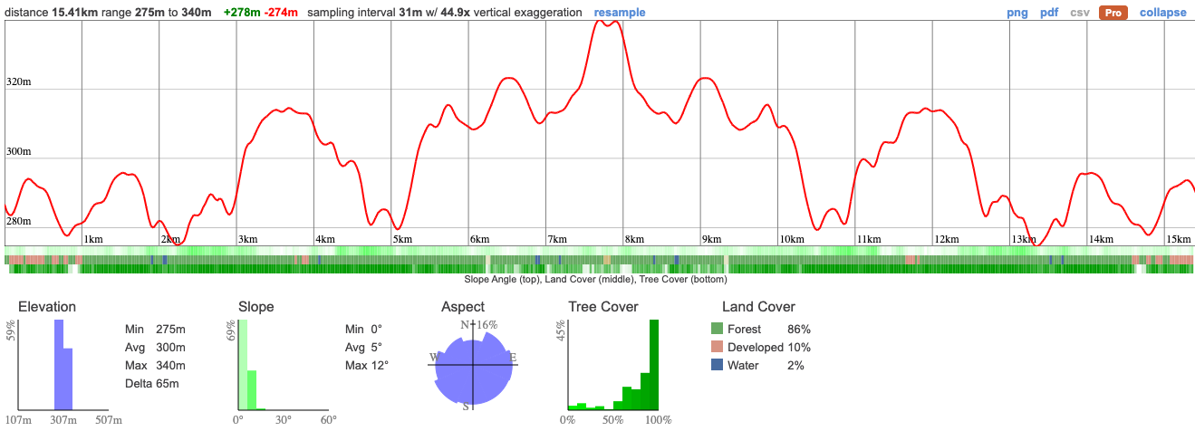
We're visiting the Southern end of Queen Elizabeth II Wildlands, a decommissioned provincial park at one of the least visited areas. Scrabble is the 2nd tallest peak in the park but at only 340m, it's not exactly K2. While there's plenty of wildlife in the park, it's hunting season so I'm expecting bears to be keeping a low profile. Visiting during peak fall colours should mean that it's particularly beautiful!
A note, my friends. Look, I know nobody reads these as carefully as I'd like them to but this time it really is important.
There are some very real dangers on this hike so you MUST download the map in advance and you MUST have everything that I've outlined otherwise, for everyone's safety you may not be able to join us.
I've reached out to many of you personally already and am confident that everyone's capable of this hike, just be prepared that it is challenging. We'll hike a total of about 16km through dense forest but on trail.
06:50 - Meet at the PetroCanada at Keele Station
07:00 - Shuttle leaves from PetroCanada at Keele Station. Please note that we leave dead on 7am and can't wait for latecomers.
09:00 - Meet self-drivers at the trailhead. Make sure you're navigating to this exact spot otherwise you're going to get lost. There's a small parking lot here marked for the use of Ganaraska Hiking Trail members. Do not be late! Fair warning, the van may end up being a few minutes late but self-drivers shouldn't come later than the van or they won't be able to join the hike.
13:30 - Lunch at the summit
16:30 - Anticipated return to car
19:00 - Approx return time to Keele Subway Station
This custom map is georeferenced, meaning it will show you where you are on the map in the right software and lays out the rough path that we’ll be following. It’s opened with the Avenza app which must be downloaded and installed in advance of the adventure.
You should also download the What3words app - this makes it easy to share and find locations in the unlikely event that you get lost.
Blaze orange clothing - It's hunting season so it's important that we're all visible. You'll need to be wearing something bright orange - think a high vis jacket (a yellow one is ok), an orange baseball cap etc. Dollarama and Canadian Tire will be a good source of affordably priced options.
A head torch - In case we end up out after dark. Unlikely but we should be prepared.
Layered clothing - No denim
Hiking boots/shoes with good grip - Running shoes are not suitable for this hike
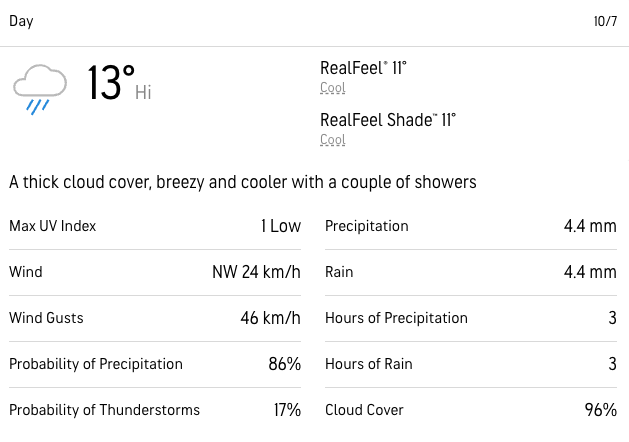
Rainwear - It looks like we'll be getting some rain
Full length pants are strongly recommended
You may wish to bring hiking poles
At least 1.5L of water
A packed lunch and snacks
Hunting - It is hunting season and there are active hunters in this park. While I don't anticipate coming across many, it's important that we're dressed in bright colours to avoid any accidents.
Ticks - Black legged ticks are rampant in the area. You should wear pants rather than shorts to prevent them latching on and lighter colours make it easier to spot them and keep you more cool. There's no need to worry about ticks if we take a few precautions and we'll talk about doing a tick check after the hike just to confirm we haven't picked any up. You can learn more here
Getting lost - This is a wilderness location, away from help so it's imperative that we stay together at all times. If you get separated from the group, stop and call for help. It's unlikely that you'll have reception during this adventure. YOU MUST STAY WITH THE GROUP AT ALL TIMES. No breaking off without first discussing it with the hike leader!
Hiking injuries - Wear appropriate footwear and hike within your abilities. If you need extra support, bring hiking poles. Any injuries? Let us know in advance of the hike.
We like to share some of the indigenous background of the areas we visit because these territories have rich histories that are easy to overlook. Indigenous communities have a connection to and respect for the land that has largely been lost since European settlement. As we strive to form a deeper connection with the land, we have much to learn from these communities. I use the Native Land map to learn more about these areas and find that developing a richer understanding leads to a greater enjoyment of the adventures.
The park is located on the traditional territories of the Missisaugas of the Credit First Nation the Anishnabe and the Huron Wendat.
Let's go into the wild! One of my favourite hikes, we're going deep into the bush to find some very unexpected surprises, a challenging hike and the satisfaction of making it to the top of Scrabble Mountain.
We're visiting the Southern end of Queen Elizabeth II Wildlands, a decommissioned provincial park at one of the least visited areas. Scrabble is the 2nd tallest peak in the park but at only 340m, it's not exactly K2. While there's plenty of wildlife in the park, it's hunting season so I'm expecting bears to be keeping a low profile. Visiting during peak fall colours should mean that it's particularly beautiful!
A note, my friends. Look, I know nobody reads these as carefully as I'd like them to but this time it really is important.
There are some very real dangers on this hike so you MUST download the map in advance and you MUST have everything that I've outlined otherwise, for everyone's safety you may not be able to join us.
I've reached out to many of you personally already and am confident that everyone's capable of this hike, just be prepared that it is challenging. We'll hike a total of about 16km through dense forest but on trail.
06:50 - Meet at the PetroCanada at Keele Station
07:00 - Shuttle leaves from PetroCanada at Keele Station. Please note that we leave dead on 7am and can't wait for latecomers.
09:00 - Meet self-drivers at the trailhead. Make sure you're navigating to this exact spot otherwise you're going to get lost. There's a small parking lot here marked for the use of Ganaraska Hiking Trail members. Do not be late! Fair warning, the van may end up being a few minutes late but self-drivers shouldn't come later than the van or they won't be able to join the hike.
13:30 - Lunch at the summit
16:30 - Anticipated return to car
19:00 - Approx return time to Keele Subway Station
This custom map is georeferenced, meaning it will show you where you are on the map in the right software and lays out the rough path that we’ll be following. It’s opened with the Avenza app which must be downloaded and installed in advance of the adventure.
You should also download the What3words app - this makes it easy to share and find locations in the unlikely event that you get lost.
Blaze orange clothing - It's hunting season so it's important that we're all visible. You'll need to be wearing something bright orange - think a high vis jacket (a yellow one is ok), an orange baseball cap etc. Dollarama and Canadian Tire will be a good source of affordably priced options.
A head torch - In case we end up out after dark. Unlikely but we should be prepared.
Layered clothing - No denim
Hiking boots/shoes with good grip - Running shoes are not suitable for this hike
Rainwear - It looks like we'll be getting some rain
Full length pants are strongly recommended
You may wish to bring hiking poles
At least 1.5L of water
A packed lunch and snacks
Hunting - It is hunting season and there are active hunters in this park. While I don't anticipate coming across many, it's important that we're dressed in bright colours to avoid any accidents.
Ticks - Black legged ticks are rampant in the area. You should wear pants rather than shorts to prevent them latching on and lighter colours make it easier to spot them and keep you more cool. There's no need to worry about ticks if we take a few precautions and we'll talk about doing a tick check after the hike just to confirm we haven't picked any up. You can learn more here
Getting lost - This is a wilderness location, away from help so it's imperative that we stay together at all times. If you get separated from the group, stop and call for help. It's unlikely that you'll have reception during this adventure. YOU MUST STAY WITH THE GROUP AT ALL TIMES. No breaking off without first discussing it with the hike leader!
Hiking injuries - Wear appropriate footwear and hike within your abilities. If you need extra support, bring hiking poles. Any injuries? Let us know in advance of the hike.
We like to share some of the indigenous background of the areas we visit because these territories have rich histories that are easy to overlook. Indigenous communities have a connection to and respect for the land that has largely been lost since European settlement. As we strive to form a deeper connection with the land, we have much to learn from these communities. I use the Native Land map to learn more about these areas and find that developing a richer understanding leads to a greater enjoyment of the adventures.
The park is located on the traditional territories of the Missisaugas of the Credit First Nation the Anishnabe and the Huron Wendat.
.jpg)