This is one of my favourite places to explore. Pristine wilderness, barely touched just a couple of hours away from the city. We'll be visiting the Western side of Queen Elizabeth II Wildlands, a decommissioned provincial park. The trail is only accessible by a very rough 20km dirt road and once you get past the trail head, we're unlikely to see another person all day.
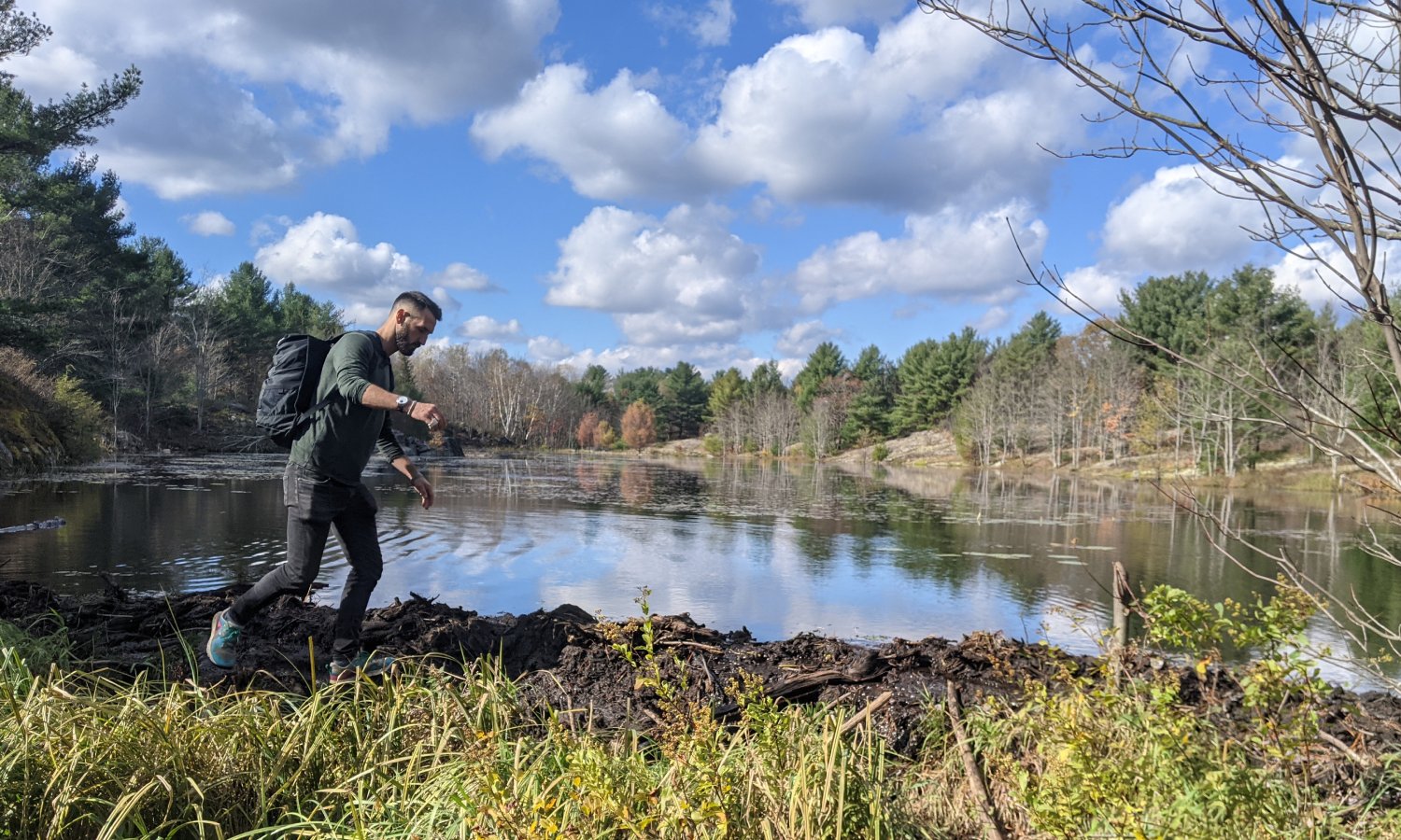
We'll cross rivers, hike across the shield, explore barrens and traverse beaver dams. It's a true adventure. At the end, there's the most welcoming rock pool you've ever seen and I'll definitely be jumping in. Bring a towel!
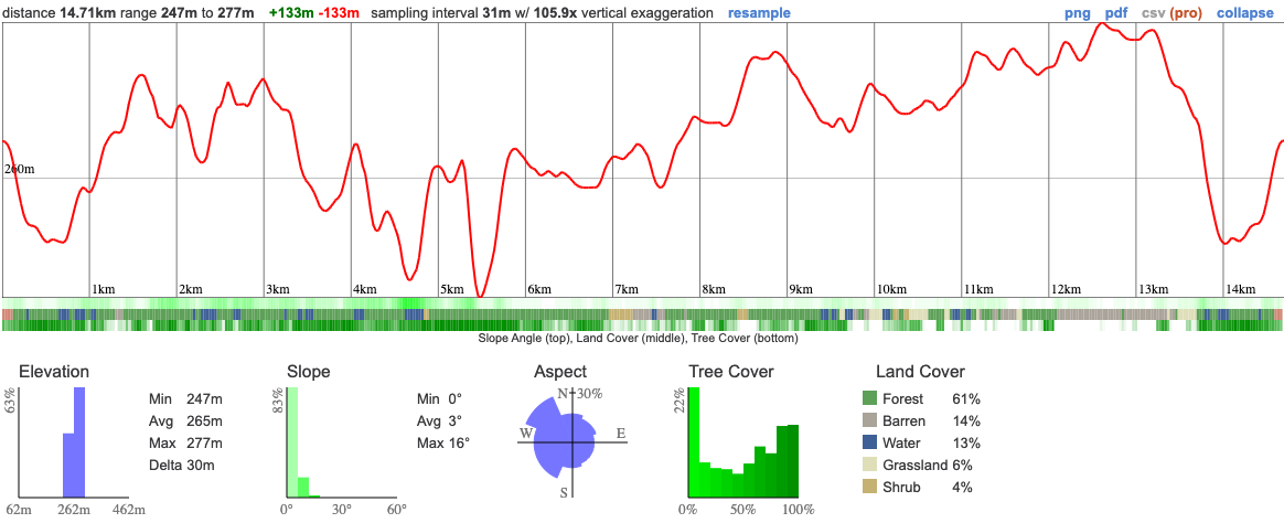
Hike Length: 15km
Terrain: Uneven rocky terrain, interspersed with mud, granite and a few beaver dams. It's a technically challenging hike that we'll want to approach carefully. We'll aim for a 2.5km pace.
Estimated time to complete: 6.5 hours with a lunch break.
07:20: Those taking the van meet at the Petrocanada next to Keele Subway Station. Note that the TTC may not have started yet so plan this carefully. Driving to the shuttle location? There's free parking here.
07:30: Shuttle leaves. Please note that out of respect for each other, we leave dead on time and can not wait for latecomers.
09:45: Meet self-drivers at trail head. This map will take you to the precise spot. A reminder that this ends with an extremely rugged trail and you'll need a vehicle with high road clearance to make it down there. We can't help you if you get stuck. Look for a small parking area BEFORE the bridge near the end of the trail.
10:00-16:30: Hike, stopping for lunch en route
16:30: Begin return to Toronto
19:00: Anticipated return to Keele subway station
This custom map is georeferenced, meaning it will show you where you are on the map in the right software and lays out the rough path that we’ll be following. It’s opened with the Avenza app which must be downloaded and installed in advance of the adventure.
You should also download the What3words app - this makes it easy to share and find locations in the unlikely event that you get lost.
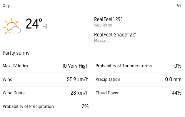
It's going to be hot and depending on our luck (or lack thereof), the bugs could be terrible. If you're sensitive to mosquitoes, pack a bug net or bug shirt and high percentage deet or Icaridin is a must. The most recent report from the park warden is that mozzies are easing off now and it's the deerflies instead.
Remember to pack a lunch, some snacks and at least 1l of water.
Hiking injuries - Wear appropriate footwear and hike within your abilities. If you need extra support, bring hiking poles.
Sunburn/heat stroke/dehydration - Wear sunscreen and a sun hat. Make sure that you hydrate regularly
Ticks - Black legged ticks are present in the area. You should wear pants rather than shorts to prevent them latching on and lighter colours make it easier to spot them and keep you more cool. There's no need to worry about ticks if we take a few precautions and we'll talk about doing a tick check after the hike just to confirm we haven't picked any up. You can learn more here
Getting lost - This is a wilderness location, away from help so it's imperative that we stay together at all times. If you get separated from the group, stop and call for help. It's unlikely that you'll have reception during this adventure.
We like to share some of the indigenous background of the areas we visit because these territories have rich histories that are easy to overlook. Indigenous communities have a connection to and respect for the land that has largely been lost since European settlement. As we strive to form a deeper connection with the land, we have much to learn from these communities. I use the Native Land map to learn more about these areas and find that developing a richer understanding leads to a greater enjoyment of the adventures.
The park is located on the traditional territories of the Missisaugas of the Credit First Nation the Anishnabe and the Huron Wendat.
This is one of my favourite places to explore. Pristine wilderness, barely touched just a couple of hours away from the city. We'll be visiting the Western side of Queen Elizabeth II Wildlands, a decommissioned provincial park. The trail is only accessible by a very rough 20km dirt road and once you get past the trail head, we're unlikely to see another person all day.
We'll cross rivers, hike across the shield, explore barrens and traverse beaver dams. It's a true adventure. At the end, there's the most welcoming rock pool you've ever seen and I'll definitely be jumping in. Bring a towel!
Hike Length: 15km
Terrain: Uneven rocky terrain, interspersed with mud, granite and a few beaver dams. It's a technically challenging hike that we'll want to approach carefully. We'll aim for a 2.5km pace.
Estimated time to complete: 6.5 hours with a lunch break.
07:20: Those taking the van meet at the Petrocanada next to Keele Subway Station. Note that the TTC may not have started yet so plan this carefully. Driving to the shuttle location? There's free parking here.
07:30: Shuttle leaves. Please note that out of respect for each other, we leave dead on time and can not wait for latecomers.
09:45: Meet self-drivers at trail head. This map will take you to the precise spot. A reminder that this ends with an extremely rugged trail and you'll need a vehicle with high road clearance to make it down there. We can't help you if you get stuck. Look for a small parking area BEFORE the bridge near the end of the trail.
10:00-16:30: Hike, stopping for lunch en route
16:30: Begin return to Toronto
19:00: Anticipated return to Keele subway station
This custom map is georeferenced, meaning it will show you where you are on the map in the right software and lays out the rough path that we’ll be following. It’s opened with the Avenza app which must be downloaded and installed in advance of the adventure.
You should also download the What3words app - this makes it easy to share and find locations in the unlikely event that you get lost.
It's going to be hot and depending on our luck (or lack thereof), the bugs could be terrible. If you're sensitive to mosquitoes, pack a bug net or bug shirt and high percentage deet or Icaridin is a must. The most recent report from the park warden is that mozzies are easing off now and it's the deerflies instead.
Remember to pack a lunch, some snacks and at least 1l of water.
Hiking injuries - Wear appropriate footwear and hike within your abilities. If you need extra support, bring hiking poles.
Sunburn/heat stroke/dehydration - Wear sunscreen and a sun hat. Make sure that you hydrate regularly
Ticks - Black legged ticks are present in the area. You should wear pants rather than shorts to prevent them latching on and lighter colours make it easier to spot them and keep you more cool. There's no need to worry about ticks if we take a few precautions and we'll talk about doing a tick check after the hike just to confirm we haven't picked any up. You can learn more here
Getting lost - This is a wilderness location, away from help so it's imperative that we stay together at all times. If you get separated from the group, stop and call for help. It's unlikely that you'll have reception during this adventure.
We like to share some of the indigenous background of the areas we visit because these territories have rich histories that are easy to overlook. Indigenous communities have a connection to and respect for the land that has largely been lost since European settlement. As we strive to form a deeper connection with the land, we have much to learn from these communities. I use the Native Land map to learn more about these areas and find that developing a richer understanding leads to a greater enjoyment of the adventures.
The park is located on the traditional territories of the Missisaugas of the Credit First Nation the Anishnabe and the Huron Wendat.