Ontario in the fall is one of the most beautiful sights to see.
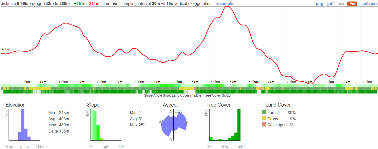
We will be taking you to a less populated trail that's part of the Niagara Escarpment. This 10 KM hike is super fun - loaded with different terrain. We'll walk through meadows and orchards, over bridges and boardwalks, past brookside stretches and even a mini waterfall.
This area is also known for it's system of labyrinths created by huge chunks of limestone that has split over time because of extreme temperatures. Exploring these tunnels and narrow corridors is exciting. Don't worry, if you're not up for it, you can always walk over or around.
There's so much to do under a colourful canopy of trees. We'll also make a few pit stops to different lookout points for awesome photo opportunities.
Hike Length: 10km
Terrain: A mixture of flat wooded areas, open fields, boulders, crevices and caves. Crevices may be a challenge to go through, but hikers can go around them instead. The hike is likely to be pretty muddy so it's extra important that you have good footwear for this trip. Sneakers are not suitable.
Estimated time to complete: 6 hours with breaks and exploration time.
07:50: Those taking the van meet at the Petro Canada next to Keele Subway Station.
08:00: Shuttle leaves. Please note that out of respect for each other, we leave dead on time and can not wait for latecomers.
10:15: Meet at the trail head - The Parking is on Side Road 9
10:30 - 16:00: Hike, stopping for lunch enroute
19:00: Anticipated return to Keele subway station
This custom map is georeferenced, meaning it will show you where you are on the map in the right software and lays out the rough path that we’ll be following. It’s opened with the Avenza app which must be downloaded and installed in advance of the adventure.
You should also download the What3words app - this makes it easy to share and find locations in the unlikely event that you get lost.
Remember to pack a lunch, some snacks and at least 1l of water.
It is first come first serve - if there is not enough parking we will go down Side Road 10
Hiking injuries - Wear appropriate footwear and hike within your abilities. If you need extra support, bring hiking poles.
Mud - It's likely to be muddy there so you'll need shoes with good grip
Ticks - The risk of Lyme Disease is very low in this area but it's always a good idea to wear long pants and sleeves as well as doing a tick check after your hike.
We like to share some of the indigenous background of the areas we visit because these territories have rich histories that are easy to overlook. Indigenous communities have a connection to and respect for the land that has largely been lost since European settlement. As we strive to form a deeper connection with the land, we have much to learn from these communities. I use the Native Land map to learn more about these areas and find that developing a richer understanding leads to a greater enjoyment of the adventures.
The Duncan Caves Trail is part of the Niagara Enscarpment which has been a significant presence to the history of several Indigenous Peoples, including the Missisaugas of the Credit First Nation, the Anishnabe, Haudenosaunee. These lands have been inhabited and cared for by Indigenous communities for thousands of years, long before the arrival of European settlers. The relationships to the land, waterways, and natural resources were, and continue to be, of vital importance to these communities. Traditional activities like hunting, fishing, trapping, and gathering have taken place here, and these landscapes are imbued with cultural and spiritual significance.
The Great Niagara Escarpment - Indigenous Cultural Map is an ongoing project to recognize and respect the traditional territories and rights of Indigenous peoples in the Niagara Escarpment region.
The colonization of these areas led to the displacement, dispossession, and disenfranchisement of Indigenous Peoples, a legacy that is still felt today. Treaties were often signed under coercive conditions, and land was frequently appropriated without the free, prior, and informed consent of the Indigenous communities concerned.
We acknowledge the traditional Indigenous caretakers of the land and are making ongoing attempts to engage with this history in a manner that respects and honours their ongoing relationship with the land.
Ontario in the fall is one of the most beautiful sights to see.
We will be taking you to a less populated trail that's part of the Niagara Escarpment. This 10 KM hike is super fun - loaded with different terrain. We'll walk through meadows and orchards, over bridges and boardwalks, past brookside stretches and even a mini waterfall.
This area is also known for it's system of labyrinths created by huge chunks of limestone that has split over time because of extreme temperatures. Exploring these tunnels and narrow corridors is exciting. Don't worry, if you're not up for it, you can always walk over or around.
There's so much to do under a colourful canopy of trees. We'll also make a few pit stops to different lookout points for awesome photo opportunities.
Hike Length: 10km
Terrain: A mixture of flat wooded areas, open fields, boulders, crevices and caves. Crevices may be a challenge to go through, but hikers can go around them instead. The hike is likely to be pretty muddy so it's extra important that you have good footwear for this trip. Sneakers are not suitable.
Estimated time to complete: 6 hours with breaks and exploration time.
07:50: Those taking the van meet at the Petro Canada next to Keele Subway Station.
08:00: Shuttle leaves. Please note that out of respect for each other, we leave dead on time and can not wait for latecomers.
10:15: Meet at the trail head - The Parking is on Side Road 9
10:30 - 16:00: Hike, stopping for lunch enroute
19:00: Anticipated return to Keele subway station
This custom map is georeferenced, meaning it will show you where you are on the map in the right software and lays out the rough path that we’ll be following. It’s opened with the Avenza app which must be downloaded and installed in advance of the adventure.
You should also download the What3words app - this makes it easy to share and find locations in the unlikely event that you get lost.
Remember to pack a lunch, some snacks and at least 1l of water.
It is first come first serve - if there is not enough parking we will go down Side Road 10
Hiking injuries - Wear appropriate footwear and hike within your abilities. If you need extra support, bring hiking poles.
Mud - It's likely to be muddy there so you'll need shoes with good grip
Ticks - The risk of Lyme Disease is very low in this area but it's always a good idea to wear long pants and sleeves as well as doing a tick check after your hike.
We like to share some of the indigenous background of the areas we visit because these territories have rich histories that are easy to overlook. Indigenous communities have a connection to and respect for the land that has largely been lost since European settlement. As we strive to form a deeper connection with the land, we have much to learn from these communities. I use the Native Land map to learn more about these areas and find that developing a richer understanding leads to a greater enjoyment of the adventures.
The Duncan Caves Trail is part of the Niagara Enscarpment which has been a significant presence to the history of several Indigenous Peoples, including the Missisaugas of the Credit First Nation, the Anishnabe, Haudenosaunee. These lands have been inhabited and cared for by Indigenous communities for thousands of years, long before the arrival of European settlers. The relationships to the land, waterways, and natural resources were, and continue to be, of vital importance to these communities. Traditional activities like hunting, fishing, trapping, and gathering have taken place here, and these landscapes are imbued with cultural and spiritual significance.
The Great Niagara Escarpment - Indigenous Cultural Map is an ongoing project to recognize and respect the traditional territories and rights of Indigenous peoples in the Niagara Escarpment region.
The colonization of these areas led to the displacement, dispossession, and disenfranchisement of Indigenous Peoples, a legacy that is still felt today. Treaties were often signed under coercive conditions, and land was frequently appropriated without the free, prior, and informed consent of the Indigenous communities concerned.
We acknowledge the traditional Indigenous caretakers of the land and are making ongoing attempts to engage with this history in a manner that respects and honours their ongoing relationship with the land.
