We're hiking the top most portion of Algonquin's longest hiking trail, the Western Uplands Backpacking Trail. It's a beautiful part of the park and one that gets relatively few visitors.
We've got a 10km hike, along old rail trails and into forest. It's a challenging hike but very achievable if you're in good shape. We end up at Islet lake, a gorgeous spot with excellent swimming opoportunities.
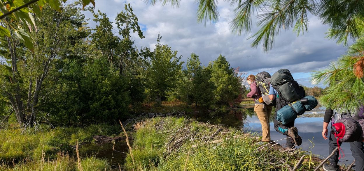
You’ll be carrying everything on your back, so even a short day feels a whole lot harder with a heavy pack. Smart packing, light gear, and a well-fitted backpack will make all the difference.
Camping
Everyone will be assigned a different responsibility at camp and together, we'll set up our home for the night each day. This involves:
Sleeping Arrangements
There's limited space on campsites so we're sharing WU provided tents separated by gender. If you'd like to bring your own hammock to sleep in, please let us know on Discord asap. You should be very comfortable setting it up, working with tarps and have tested your sleep system in advance.
Backcountry considerations and using the toilet
This being remote backcountry, you'll have no phone reception, there's no electricity or running water. There may or may not be thunderboxes (wooden toilets) on site, so you may also be digging catholes to go to the toilet. This is a great guide to pooping in the woods!
Water
There's a risk of water contamination with protozoa like Giardia (beaver fever!) and bacteria so we'll be purifying water on site. We'll be providing all necessary equipment for water purification but feel free to bring your chosen method in addition.
Campsite responsibilities
This trip is an opportunity to build your skills so we'll all be mucking in to make the trip a success. We'll divide up responsibilities on the campsite so you learn how to set up a tent, do a bear hang, purify water etc. We'll also share in the work to cook and keep things clean. Is there something you really want to learn while we're out? Do you have skills you could share with the group? PM us on Discord and let's work it in.
Maps
Please ensure you download the maps in advance
Saturday October 25th
06:50- Meet at the PetroCanada next to Keele Station. There's a Tims around the corner if you want to grab breakfast. THE BUS WILL LEAVE AT 07:00 whether you are here or not so you must be there on time.
07:00 - Van leaves
10:30 - Arrive at Rain Lake Access Point and meet any self drivers
11:00 – 13:30 – Hike to campsite
13:30 – 18:00 – Set up camp. Hang out at the campsite. Learn camp skills, swim, or just relax in a hammock
18:00 – Dinner
Evening – Fireside hangs and stargazing
Sunday 26th October
Morning – Breakfast and exploration before packing up and hiking out.
15:00 - Arrive back at the trail head
19:00 – Return to Toronto feeling utterly reset and refreshed
This custom map is georeferenced, meaning it will show you where you are on the map in the right software and lays out the rough path that we’ll be following. It’s opened with the Avenza app which must be downloaded and installed in advance of the adventure.
You should also download the What3words app - this makes it easy to share and find locations in the unlikely event that you get lost.
You’ll be carrying everything on your back, so even a short day feels a whole lot harder with a heavy pack. Smart packing, light gear, and a well-fitted backpack will make all the difference. This is a suggested list but dress for the weather!:
Clothing
Gear
Camping Gear / Sleep System
(Tents are provided.)
Personal Stuff
Period Products
Wondering how to handle camping on your period? Here's a great resource with everything you could need to know. If you still have questions, Marie K has offered to answer any questions - you can message her privately on Discord.
We'll be providing most meals (either vegan or meaty according to your dietary requirements) for this adventure along with tea and coffee but no milk.
You may also want to pack some light snacks to fuel while hiking.
You're responsible for your own breakfast (before we meet) and a packed lunch on day 1.
We've really upped the quality of our meals this year and you can look forward to improved food options, even on backcountry trips! Don't forget to update your profile and notify us if your dietary restrictions have changed.
We'll provide the following:
You should read all of the instructions in here carefully and make sure you've downloaded and installed the map! It's important that you listen to the guides and follow their instructions at all times.
Drowning: You should only swim where you've been told is safe to do so and only under the supervision of a guide. Non swimmers should stay out of the water for this trip.
Hiking injuries: Wear appropriate footwear (ankle high hiking boots) and hike within your abilities. If you need extra support, bring hiking poles.
Getting lost: This is a wilderness location, away from help so it's imperative that we stay together at all times. If you get separated from the group, stop and call for help. It's unlikely that you'll have reception during this adventure. YOU MUST STAY WITH THE GROUP AT ALL TIMES. No breaking off without first discussing it with the hike leader!
Trail conditions: Trails may be muddy, ensure you're wearing proper footwear with tread and ankle support.
Falling from heights: There are some steep cliffs on this trail, don't get too close to any.
Wildlife: Bears and moose are not uncommon around this area. If you come across a larger animal, back away and alert the group.
We like to share some of the indigenous background of the areas we visit because these territories have rich histories that are easy to overlook. Indigenous communities have a connection to and respect for the land that has largely been lost since European settlement. As we strive to form a deeper connection with the land, we have much to learn from these communities. I use the Native Land map to learn more about these areas and find that developing a richer understanding leads to a greater enjoyment of the adventures.
We're hiking the top most portion of Algonquin's longest hiking trail, the Western Uplands Backpacking Trail. It's a beautiful part of the park and one that gets relatively few visitors.
We've got a 10km hike, along old rail trails and into forest. It's a challenging hike but very achievable if you're in good shape. We end up at Islet lake, a gorgeous spot with excellent swimming opoportunities.
You’ll be carrying everything on your back, so even a short day feels a whole lot harder with a heavy pack. Smart packing, light gear, and a well-fitted backpack will make all the difference.
Camping
Everyone will be assigned a different responsibility at camp and together, we'll set up our home for the night each day. This involves:
Sleeping Arrangements
There's limited space on campsites so we're sharing WU provided tents separated by gender. If you'd like to bring your own hammock to sleep in, please let us know on Discord asap. You should be very comfortable setting it up, working with tarps and have tested your sleep system in advance.
Backcountry considerations and using the toilet
This being remote backcountry, you'll have no phone reception, there's no electricity or running water. There may or may not be thunderboxes (wooden toilets) on site, so you may also be digging catholes to go to the toilet. This is a great guide to pooping in the woods!
Water
There's a risk of water contamination with protozoa like Giardia (beaver fever!) and bacteria so we'll be purifying water on site. We'll be providing all necessary equipment for water purification but feel free to bring your chosen method in addition.
Campsite responsibilities
This trip is an opportunity to build your skills so we'll all be mucking in to make the trip a success. We'll divide up responsibilities on the campsite so you learn how to set up a tent, do a bear hang, purify water etc. We'll also share in the work to cook and keep things clean. Is there something you really want to learn while we're out? Do you have skills you could share with the group? PM us on Discord and let's work it in.
Maps
Please ensure you download the maps in advance
Saturday October 25th
06:50- Meet at the PetroCanada next to Keele Station. There's a Tims around the corner if you want to grab breakfast. THE BUS WILL LEAVE AT 07:00 whether you are here or not so you must be there on time.
07:00 - Van leaves
10:30 - Arrive at Rain Lake Access Point and meet any self drivers
11:00 – 13:30 – Hike to campsite
13:30 – 18:00 – Set up camp. Hang out at the campsite. Learn camp skills, swim, or just relax in a hammock
18:00 – Dinner
Evening – Fireside hangs and stargazing
Sunday 26th October
Morning – Breakfast and exploration before packing up and hiking out.
15:00 - Arrive back at the trail head
19:00 – Return to Toronto feeling utterly reset and refreshed
This custom map is georeferenced, meaning it will show you where you are on the map in the right software and lays out the rough path that we’ll be following. It’s opened with the Avenza app which must be downloaded and installed in advance of the adventure.
You should also download the What3words app - this makes it easy to share and find locations in the unlikely event that you get lost.
You’ll be carrying everything on your back, so even a short day feels a whole lot harder with a heavy pack. Smart packing, light gear, and a well-fitted backpack will make all the difference. This is a suggested list but dress for the weather!:
Clothing
Gear
Camping Gear / Sleep System
(Tents are provided.)
Personal Stuff
Period Products
Wondering how to handle camping on your period? Here's a great resource with everything you could need to know. If you still have questions, Marie K has offered to answer any questions - you can message her privately on Discord.
We'll be providing most meals (either vegan or meaty according to your dietary requirements) for this adventure along with tea and coffee but no milk.
You may also want to pack some light snacks to fuel while hiking.
You're responsible for your own breakfast (before we meet) and a packed lunch on day 1.
We've really upped the quality of our meals this year and you can look forward to improved food options, even on backcountry trips! Don't forget to update your profile and notify us if your dietary restrictions have changed.
We'll provide the following:
You should read all of the instructions in here carefully and make sure you've downloaded and installed the map! It's important that you listen to the guides and follow their instructions at all times.
Drowning: You should only swim where you've been told is safe to do so and only under the supervision of a guide. Non swimmers should stay out of the water for this trip.
Hiking injuries: Wear appropriate footwear (ankle high hiking boots) and hike within your abilities. If you need extra support, bring hiking poles.
Getting lost: This is a wilderness location, away from help so it's imperative that we stay together at all times. If you get separated from the group, stop and call for help. It's unlikely that you'll have reception during this adventure. YOU MUST STAY WITH THE GROUP AT ALL TIMES. No breaking off without first discussing it with the hike leader!
Trail conditions: Trails may be muddy, ensure you're wearing proper footwear with tread and ankle support.
Falling from heights: There are some steep cliffs on this trail, don't get too close to any.
Wildlife: Bears and moose are not uncommon around this area. If you come across a larger animal, back away and alert the group.
We like to share some of the indigenous background of the areas we visit because these territories have rich histories that are easy to overlook. Indigenous communities have a connection to and respect for the land that has largely been lost since European settlement. As we strive to form a deeper connection with the land, we have much to learn from these communities. I use the Native Land map to learn more about these areas and find that developing a richer understanding leads to a greater enjoyment of the adventures.