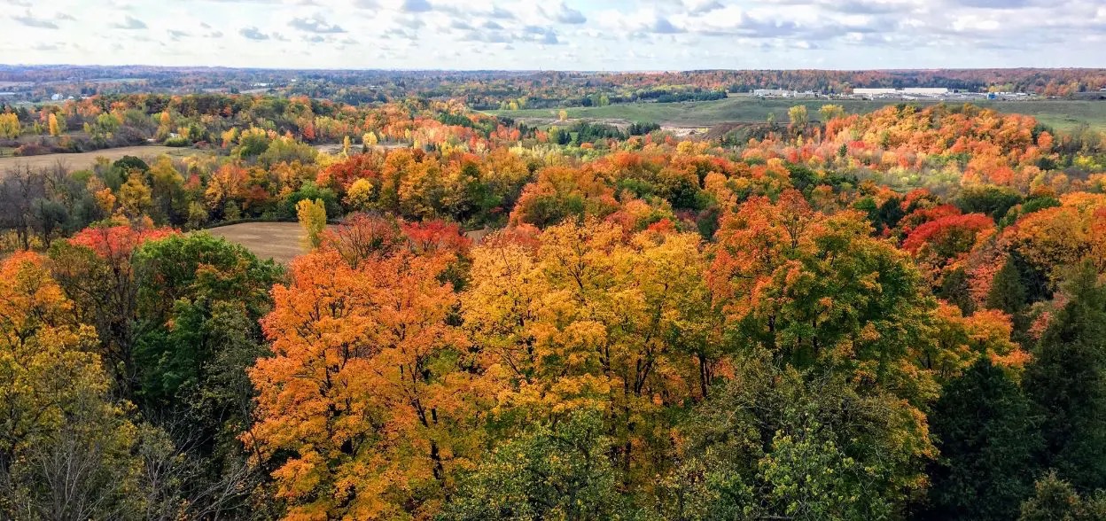
Probably the best place in all of the GTA for Fall colour viewing. As the season progresses, the full show of colours makes its way further South and we should be visiting during the absolute peak.
Rattlesnake Point is beautiful any time but during Fall, it's spectacular. The trail weaves along the Niagara Escarpment and takes us high up on cliffs that give some incredible panoramic views over the surrounding area. We'll take a trail that brings us into the Nassagaweya Canyon, bringing us through dense forest and into wide open viewpoints before winding along the Bruce Trail.
This will be an easy 8.5km hike and, being just under an hour from the city, a relatively easy trip to experience some breathtaking nature.
Anybody booking transport will have their access to the park included. Those self driving will need to reserve tickets and pay the $10.50 entrance fee.
Hike length: 9km
Estimated time to complete hike: 5 hours
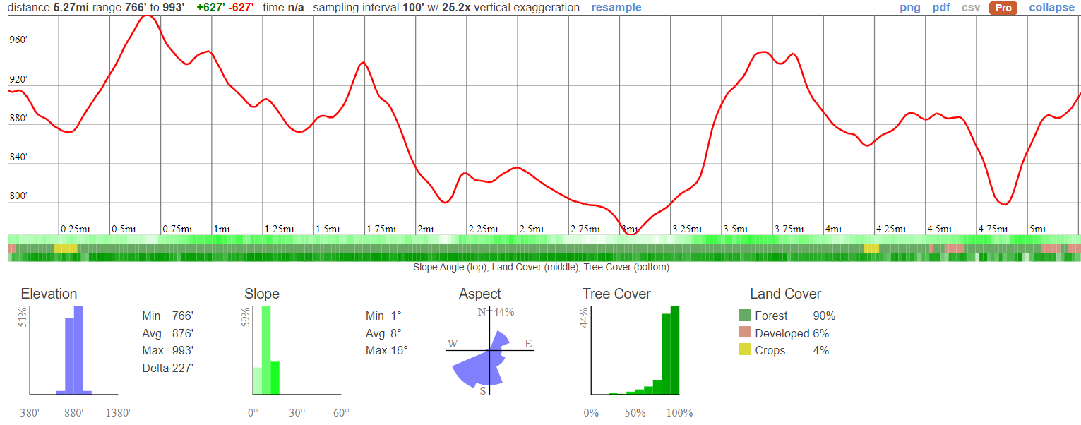
This is a moderate hike with a few steeper sections. We'll take it slowly on the inclines and make up time on the flat. Depending on how much time we spend checking out the area, it's also possible that we may just do one of the two loops on the route, reducing the overall distance by about 4.5km. We'll play that by ear according to our progress.
08:50 - Those getting a ride meet up at the Petrocanada next to Keele Subway Station
09:00 - Shuttle leaves. Please note, we leave dead on time and cannot wait for latecomers!
09:45 - Arrive at Rattlesnake Point, meet up with self drivers and begin hike. Self-Drivers - you'll find us by the big white bus.
10:00-15:00 - Hike the 9km looped trail with lunch on the way
16:30 - Anticipated return to Keele Station
This custom map is georeferenced, meaning it will show you where you are on the map in the right software and lays out the rough path that we’ll be following. It’s opened with the Avenza app which must be downloaded and installed in advance of the adventure.
You should also download the What3words app - this makes it easy to share and find locations in the unlikely event that you get lost.
It's looking like it will be super hot! Make sure you're dressed appropriately and have plenty of water.
Packing list
Have any questions? Ask us on the Discord!
Grab breakfast before you go. There's a Tims around the corner from our meet-up point.
Bring a packed lunch, snacks and at least a 2 litres of water for the hike. We also reccomend electolyte drinks for hot days!
Self drivers are strongly recommended to reserve admission in advance here and save a few bucks. Entrance is $10.50 per person in advance, $12 at the gate. Those travelling in the van have their entrance covered.
You should read all of the instructions in here carefully and make sure you've downloaded and installed the map! It's important that you listen to the guides and follow their instructions at all times.
Hiking injuries - Wear appropriate footwear (ankle high hiking boots) and hike within your abilities. If you need extra support, bring hiking poles.
Cliffs - Keep away from any steep drops.
Getting lost - Stay with the group at all times, follow the instructions of the guides and download both the map referenced above as well as What3Words. You can't rely on having reception while out in the woods.
Ticks - Tick season has started again and they're active in the area we're visiting. Black Legged Ticks have the risk of carrying Lyme disease so it's important that you check yourself thoroughly after each hike. You're also recommended to have your legs covered so it's harder for them to latch on. Learn about checking for ticks here.
Crawford Lake has a particulary interesting Indigenous history that we'll learn about while we're there. The lake and surrounding area were once home to a thriving Iroquoian village in the 15th century, before European contact.
In the early 1970s, researchers from the University of Toronto made a remarkable discovery while studying sediment cores from Crawford Lake. They detected high levels of corn pollen in layers dating back to the 13th-15th centuries, suggesting that the area was inhabited by an agricultural society during that time. This finding led to archaeological excavations which uncovered the remains of a pre-colonial Wendat (Huron) or Attawandaron (Neutral) village near the lake.
The village likely housed around 300 people from the ancestors of the Wendat or Attawandaron Nations. They cultivated crops like corn, beans, and squash, which allowed them to establish a more permanent settlement. Longhouses were built to shelter extended families, with each clan living communally.
For unknown reasons, the village was abandoned sometime in the early 16th century. The area then became a hunting ground for other Indigenous groups like the Mississaugas. When European settlers arrived in the late 18th century, the Mississaugas negotiated land agreements with the British, opening up the region for settlement.
Today, Crawford Lake Conservation Area works closely with Indigenous partners to educate the public about the area's history. Three longhouses have been reconstructed on their original footprints. Exhibits, gardens, workshops and educational programs developed collaboratively with Indigenous Knowledge Keepers, Elders and artists help share the stories of the land's original inhabitants.
Probably the best place in all of the GTA for Fall colour viewing. As the season progresses, the full show of colours makes its way further South and we should be visiting during the absolute peak.
Rattlesnake Point is beautiful any time but during Fall, it's spectacular. The trail weaves along the Niagara Escarpment and takes us high up on cliffs that give some incredible panoramic views over the surrounding area. We'll take a trail that brings us into the Nassagaweya Canyon, bringing us through dense forest and into wide open viewpoints before winding along the Bruce Trail.
This will be an easy 8.5km hike and, being just under an hour from the city, a relatively easy trip to experience some breathtaking nature.
Anybody booking transport will have their access to the park included. Those self driving will need to reserve tickets and pay the $10.50 entrance fee.
Hike length: 9km
Estimated time to complete hike: 5 hours
This is a moderate hike with a few steeper sections. We'll take it slowly on the inclines and make up time on the flat. Depending on how much time we spend checking out the area, it's also possible that we may just do one of the two loops on the route, reducing the overall distance by about 4.5km. We'll play that by ear according to our progress.
08:50 - Those getting a ride meet up at the Petrocanada next to Keele Subway Station
09:00 - Shuttle leaves. Please note, we leave dead on time and cannot wait for latecomers!
09:45 - Arrive at Rattlesnake Point, meet up with self drivers and begin hike. Self-Drivers - you'll find us by the big white bus.
10:00-15:00 - Hike the 9km looped trail with lunch on the way
16:30 - Anticipated return to Keele Station
This custom map is georeferenced, meaning it will show you where you are on the map in the right software and lays out the rough path that we’ll be following. It’s opened with the Avenza app which must be downloaded and installed in advance of the adventure.
You should also download the What3words app - this makes it easy to share and find locations in the unlikely event that you get lost.
It's looking like it will be super hot! Make sure you're dressed appropriately and have plenty of water.
Packing list
Have any questions? Ask us on the Discord!
Grab breakfast before you go. There's a Tims around the corner from our meet-up point.
Bring a packed lunch, snacks and at least a 2 litres of water for the hike. We also reccomend electolyte drinks for hot days!
Self drivers are strongly recommended to reserve admission in advance here and save a few bucks. Entrance is $10.50 per person in advance, $12 at the gate. Those travelling in the van have their entrance covered.
You should read all of the instructions in here carefully and make sure you've downloaded and installed the map! It's important that you listen to the guides and follow their instructions at all times.
Hiking injuries - Wear appropriate footwear (ankle high hiking boots) and hike within your abilities. If you need extra support, bring hiking poles.
Cliffs - Keep away from any steep drops.
Getting lost - Stay with the group at all times, follow the instructions of the guides and download both the map referenced above as well as What3Words. You can't rely on having reception while out in the woods.
Ticks - Tick season has started again and they're active in the area we're visiting. Black Legged Ticks have the risk of carrying Lyme disease so it's important that you check yourself thoroughly after each hike. You're also recommended to have your legs covered so it's harder for them to latch on. Learn about checking for ticks here.
Crawford Lake has a particulary interesting Indigenous history that we'll learn about while we're there. The lake and surrounding area were once home to a thriving Iroquoian village in the 15th century, before European contact.
In the early 1970s, researchers from the University of Toronto made a remarkable discovery while studying sediment cores from Crawford Lake. They detected high levels of corn pollen in layers dating back to the 13th-15th centuries, suggesting that the area was inhabited by an agricultural society during that time. This finding led to archaeological excavations which uncovered the remains of a pre-colonial Wendat (Huron) or Attawandaron (Neutral) village near the lake.
The village likely housed around 300 people from the ancestors of the Wendat or Attawandaron Nations. They cultivated crops like corn, beans, and squash, which allowed them to establish a more permanent settlement. Longhouses were built to shelter extended families, with each clan living communally.
For unknown reasons, the village was abandoned sometime in the early 16th century. The area then became a hunting ground for other Indigenous groups like the Mississaugas. When European settlers arrived in the late 18th century, the Mississaugas negotiated land agreements with the British, opening up the region for settlement.
Today, Crawford Lake Conservation Area works closely with Indigenous partners to educate the public about the area's history. Three longhouses have been reconstructed on their original footprints. Exhibits, gardens, workshops and educational programs developed collaboratively with Indigenous Knowledge Keepers, Elders and artists help share the stories of the land's original inhabitants.