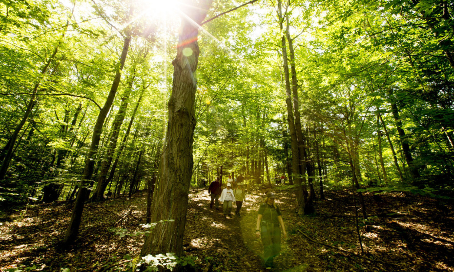
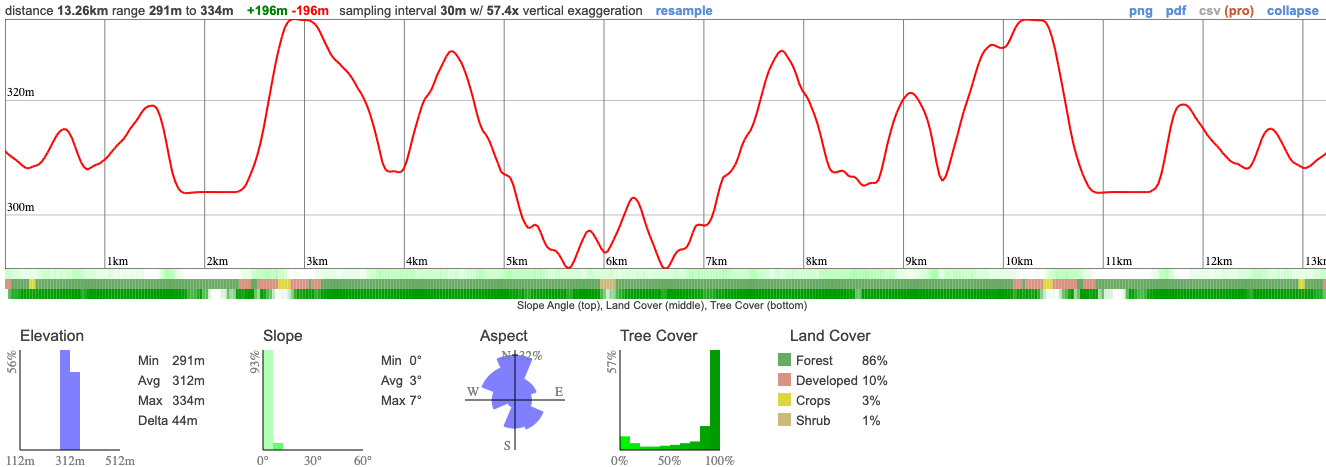
We're visiting the Goldie Feldman reserve to hike one of the remaining intact forests in the Oak Ridges Moraine. This area is renowned for its oak forests and dramatic ridges created by glacial activity. We'll be setting out on a moderately challenging 13 KM trail that will take us through forest ridges, wetlands and meadows.
This hike is moderately challenging with inclines, declines and easy boardwalks. We'll rest and eat lunch along the route, taking in the dense forest and critters that call it home.
This is a special place, both because of how rare it is to find untouched forest but also how few people visit this spot.
Hike Length: 13km
Terrain: A moderately challenging hike mostly due to the length of this adventure. We'll be on forested trails with a decent amount of ups and downs
Estimated time to complete: 6 hours with breaks and exploration time.
09:30 - Shuttle leaves from PetroCanada near Keele TTC
10:30 - Arrive at trail head and begin hike, eating lunch en route
16:30 - Return to shuttle
17:30 - Anticipated return to Toronto
This custom map is georeferenced, meaning it will show you where you are on the map in the right software and lays out the rough path that we’ll be following. It’s opened with the Avenza app which must be downloaded and installed in advance of the adventure.
You should also download the What3words app - this makes it easy to share and find locations in the unlikely event that you get lost.
It's still going to be hot and there's the chance of bugs and a thunderstorm!
Remember to pack a lunch, some snacks and at least 1l of water.
Hiking injuries - Wear appropriate footwear and hike within your abilities. If you need extra support, bring hiking poles.
Sunburn/heat stroke/dehydration - Wear sunscreen and a sun hat. Make sure that you hydrate regularly
Ticks - Black legged ticks are present in the area. You should wear pants rather than shorts to prevent them latching on and lighter colours make it easier to spot them and keep you more cool. There's no need to worry about ticks if we take a few precautions and we'll talk about doing a tick check after the hike just to confirm we haven't picked any up. You can learn more here
Thunderstorms - If there is a bad thunderstorm, we'll make a safety assessment and could cut the hike short.
We like to share some of the indigenous background of the areas we visit because these territories have rich histories that are easy to overlook. Indigenous communities have a connection to and respect for the land that has largely been lost since European settlement. As we strive to form a deeper connection with the land, we have much to learn from these communities. I use the Native Land map to learn more about these areas and find that developing a richer understanding leads to a greater enjoyment of the adventures.
We'll be close to Happy Valley, an area that has had a large number of first nations in the area, including the the Mississaugas of the Credit First Nation,the Anishnabe, Haudenosaunee, Petun (who you may remember from our last rural hike), the Mississauga nation and the Huron Wendat.
We're visiting the Goldie Feldman reserve to hike one of the remaining intact forests in the Oak Ridges Moraine. This area is renowned for its oak forests and dramatic ridges created by glacial activity. We'll be setting out on a moderately challenging 13 KM trail that will take us through forest ridges, wetlands and meadows.
This hike is moderately challenging with inclines, declines and easy boardwalks. We'll rest and eat lunch along the route, taking in the dense forest and critters that call it home.
This is a special place, both because of how rare it is to find untouched forest but also how few people visit this spot.
Hike Length: 13km
Terrain: A moderately challenging hike mostly due to the length of this adventure. We'll be on forested trails with a decent amount of ups and downs
Estimated time to complete: 6 hours with breaks and exploration time.
09:30 - Shuttle leaves from PetroCanada near Keele TTC
10:30 - Arrive at trail head and begin hike, eating lunch en route
16:30 - Return to shuttle
17:30 - Anticipated return to Toronto
This custom map is georeferenced, meaning it will show you where you are on the map in the right software and lays out the rough path that we’ll be following. It’s opened with the Avenza app which must be downloaded and installed in advance of the adventure.
You should also download the What3words app - this makes it easy to share and find locations in the unlikely event that you get lost.
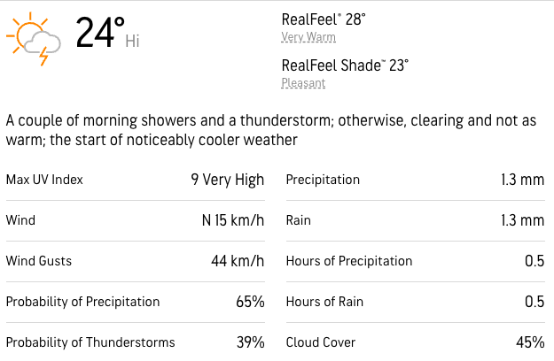
It's still going to be hot and there's the chance of bugs and a thunderstorm!
Remember to pack a lunch, some snacks and at least 1l of water.
Hiking injuries - Wear appropriate footwear and hike within your abilities. If you need extra support, bring hiking poles.
Sunburn/heat stroke/dehydration - Wear sunscreen and a sun hat. Make sure that you hydrate regularly
Ticks - Black legged ticks are present in the area. You should wear pants rather than shorts to prevent them latching on and lighter colours make it easier to spot them and keep you more cool. There's no need to worry about ticks if we take a few precautions and we'll talk about doing a tick check after the hike just to confirm we haven't picked any up. You can learn more here
Thunderstorms - If there is a bad thunderstorm, we'll make a safety assessment and could cut the hike short.
We like to share some of the indigenous background of the areas we visit because these territories have rich histories that are easy to overlook. Indigenous communities have a connection to and respect for the land that has largely been lost since European settlement. As we strive to form a deeper connection with the land, we have much to learn from these communities. I use the Native Land map to learn more about these areas and find that developing a richer understanding leads to a greater enjoyment of the adventures.
We'll be close to Happy Valley, an area that has had a large number of first nations in the area, including the the Mississaugas of the Credit First Nation,the Anishnabe, Haudenosaunee, Petun (who you may remember from our last rural hike), the Mississauga nation and the Huron Wendat.