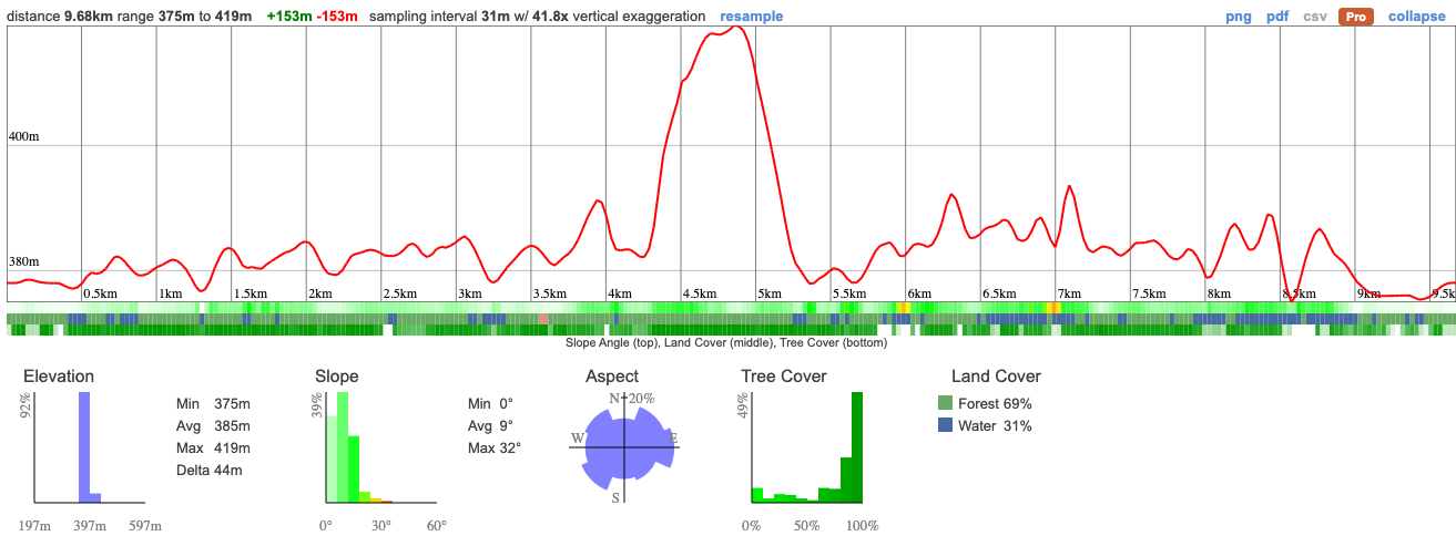
This week's secret wilderness hike is at Limberlost Forest and Wildlife Reserve, just on the edge of Algonquin Park. We'll be hiking 10km around Solitaire lake, across boardwalks, through gorgeous forest and along massive granite features. It's looking like we'll have beautiful weather for the day - this should be an incredible first trip to this little-known spot.
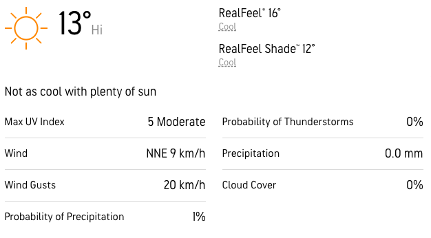
This is a relatively easy hike with big pay-offs. There's just one steep climb so it should be suitable for anyone with a decent level of fitness. We're expecting some snow up there this week, which may or may not have melted by the time we visit. We'll be packing ice spikes just in case and it may be muddy underfoot.
The whole hike should take 5 hours with breaks.
06:50 - Meet at the PetroCanada next to Keele Station. There's a Tims around the corner if you want to grab breakfast.
07:00 - Head off to Limberlost.
09:45 - Meet at Trail-head. Self-drivers, please ensure you're there on time, we can't wait for latecomers
09:45 - 15:00- Hike
18:00 - Anticipated arrival back at Keele Station
This custom map is georeferenced, meaning it will show you where you are on the map in the right software and lays out the rough path that we’ll be following. It’s opened with the Avenza app which must be downloaded and installed in advance of the adventure.
You should also download the What3words app - this makes it easy to share and find locations in the unlikely event that you get lost.
General Notes
The snow may have melted so we could have a mixture of slippery muddy conditions. Please read the following carefully - if you're not dressed safely we will not be able to take you up with us and we all want to avoid that!
That starts with:
Shoes
Hiking boots are essential for this trip. You're going to need good grip and a higher shoe to prevent your feet getting soaked. That's likely to happen anyway so make sure you pack an extra pair of socks.
Trainers and city boots are really not suitable because they won't have sufficient grip and could put you at risk. You won't be able to join us if you're wearing sneakers/blundstones.
Traction
We're not expecting much snow on the trail but if you have ice spikes, you should pack them. We have extras for those who need them.
Clothing packing list
It's also a good idea to bring a whistle in case you need to call for help.
Have any questions? Ask us on the Discord! Members who turn up dressed in a way that puts themselves at risk will not be able to join us.
Have breakfast before you meet us and bring a packed lunch, snacks and at least 1l of water.
We'll be making a short stop en route to the park and may not have enough time to get food so don't rely on this.
We'll have ice spikes available for those who need them.
You should read all of the instructions in here carefully and make sure you've downloaded and installed the map! It's important that you listen to the guides and follow their instructions at all times.
Hiking injuries: There are a lot of rocks on the trail and it's easy to roll an ankle. Be careful when walking and bring poles if helpful.
Getting lost: All hikers must remain with the group at all times. If you do find yourself lost at any point, stay where you are and call for help. If you have a whistle, bring it.
Trail conditions: Trails may be slippery, ensure you're wearing ice spikes if recommended.
Falling from heights: There are some steep sections on this trail, don't get too close to any cliffs.
Wildlife: Bears and moose are not uncommon around this area. If you come across a larger animal, back away and alert the group.
The area around Limberlost has a rich indigenous history that predates the establishment of the park itself. The park is situated on the traditional territories of several Algonquian-speaking First Nations, including the Algonquin, Anishinaabe, and Huron-Wendat peoples.
For thousands of years, these indigenous communities relied on the land and its resources for sustenance, trade, and cultural practices. They engaged in hunting, fishing, gathering, and agriculture, establishing seasonal camps and villages throughout the region. The lakes, rivers, and forests provided them with a diverse range of food, such as fish, game, berries, and medicinal plants.
The Algonquin people, in particular, have a deep connection to the land that encompasses Algonquin Park. They refer to themselves as Anishinaabe, which translates to "the people" in their language. Their traditional territories extended across a vast area in present-day Ontario and Quebec.
This week's secret wilderness hike is at Limberlost Forest and Wildlife Reserve, just on the edge of Algonquin Park. We'll be hiking 10km around Solitaire lake, across boardwalks, through gorgeous forest and along massive granite features. It's looking like we'll have beautiful weather for the day - this should be an incredible first trip to this little-known spot.
This is a relatively easy hike with big pay-offs. There's just one steep climb so it should be suitable for anyone with a decent level of fitness. We're expecting some snow up there this week, which may or may not have melted by the time we visit. We'll be packing ice spikes just in case and it may be muddy underfoot.
The whole hike should take 5 hours with breaks.
06:50 - Meet at the PetroCanada next to Keele Station. There's a Tims around the corner if you want to grab breakfast.
07:00 - Head off to Limberlost.
09:45 - Meet at Trail-head. Self-drivers, please ensure you're there on time, we can't wait for latecomers
09:45 - 15:00- Hike
18:00 - Anticipated arrival back at Keele Station
This custom map is georeferenced, meaning it will show you where you are on the map in the right software and lays out the rough path that we’ll be following. It’s opened with the Avenza app which must be downloaded and installed in advance of the adventure.
You should also download the What3words app - this makes it easy to share and find locations in the unlikely event that you get lost.
General Notes
The snow may have melted so we could have a mixture of slippery muddy conditions. Please read the following carefully - if you're not dressed safely we will not be able to take you up with us and we all want to avoid that!
That starts with:
Shoes
Hiking boots are essential for this trip. You're going to need good grip and a higher shoe to prevent your feet getting soaked. That's likely to happen anyway so make sure you pack an extra pair of socks.
Trainers and city boots are really not suitable because they won't have sufficient grip and could put you at risk. You won't be able to join us if you're wearing sneakers/blundstones.
Traction
We're not expecting much snow on the trail but if you have ice spikes, you should pack them. We have extras for those who need them.
Clothing packing list
It's also a good idea to bring a whistle in case you need to call for help.
Have any questions? Ask us on the Discord! Members who turn up dressed in a way that puts themselves at risk will not be able to join us.
Have breakfast before you meet us and bring a packed lunch, snacks and at least 1l of water.
We'll be making a short stop en route to the park and may not have enough time to get food so don't rely on this.
We'll have ice spikes available for those who need them.
You should read all of the instructions in here carefully and make sure you've downloaded and installed the map! It's important that you listen to the guides and follow their instructions at all times.
Hiking injuries: There are a lot of rocks on the trail and it's easy to roll an ankle. Be careful when walking and bring poles if helpful.
Getting lost: All hikers must remain with the group at all times. If you do find yourself lost at any point, stay where you are and call for help. If you have a whistle, bring it.
Trail conditions: Trails may be slippery, ensure you're wearing ice spikes if recommended.
Falling from heights: There are some steep sections on this trail, don't get too close to any cliffs.
Wildlife: Bears and moose are not uncommon around this area. If you come across a larger animal, back away and alert the group.
The area around Limberlost has a rich indigenous history that predates the establishment of the park itself. The park is situated on the traditional territories of several Algonquian-speaking First Nations, including the Algonquin, Anishinaabe, and Huron-Wendat peoples.
For thousands of years, these indigenous communities relied on the land and its resources for sustenance, trade, and cultural practices. They engaged in hunting, fishing, gathering, and agriculture, establishing seasonal camps and villages throughout the region. The lakes, rivers, and forests provided them with a diverse range of food, such as fish, game, berries, and medicinal plants.
The Algonquin people, in particular, have a deep connection to the land that encompasses Algonquin Park. They refer to themselves as Anishinaabe, which translates to "the people" in their language. Their traditional territories extended across a vast area in present-day Ontario and Quebec.
