Join us for an unforgettable day trip to stunning Killarney Provincial Park, where we'll embark on one of Ontario's most iconic hikes - The Crack. This challenging and technical hike has absolutely incredible views from the top.
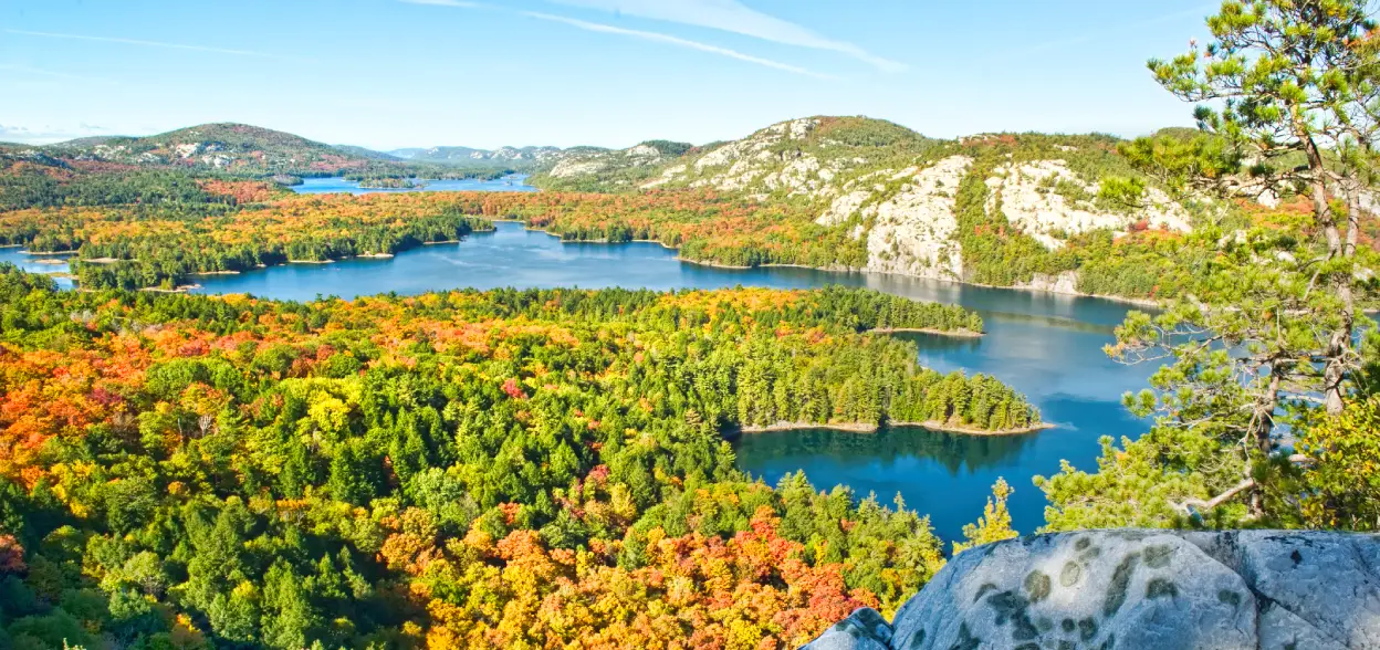
As we venture into the heart of Killarney, the rugged beauty of the Canadian Shield will surround us, with ancient rocks and lush forests setting the scene. The Crack Trail, famous for its unique geological features, will see us ascending through rocky crevices, traversing steep inclines to reach the awe-inspiring summit.
Throughout the hike, we'll be treated to panoramic views of the pristine wilderness, and surrounding lakes. The sheer beauty and untamed landscape make every step of this journey more rewarding.
The Crack trail is a physically demanding hike, and participants should be prepared for the strenuous terrain. However, with a bit of determination and enthusiasm, members with a decent level of fitness and no injuries will be more than capable of taking on this thrilling adventure.
This will be a long day (it's a 4hr drive to Killarney) but it's a real bucket list experience that's worth the trek.
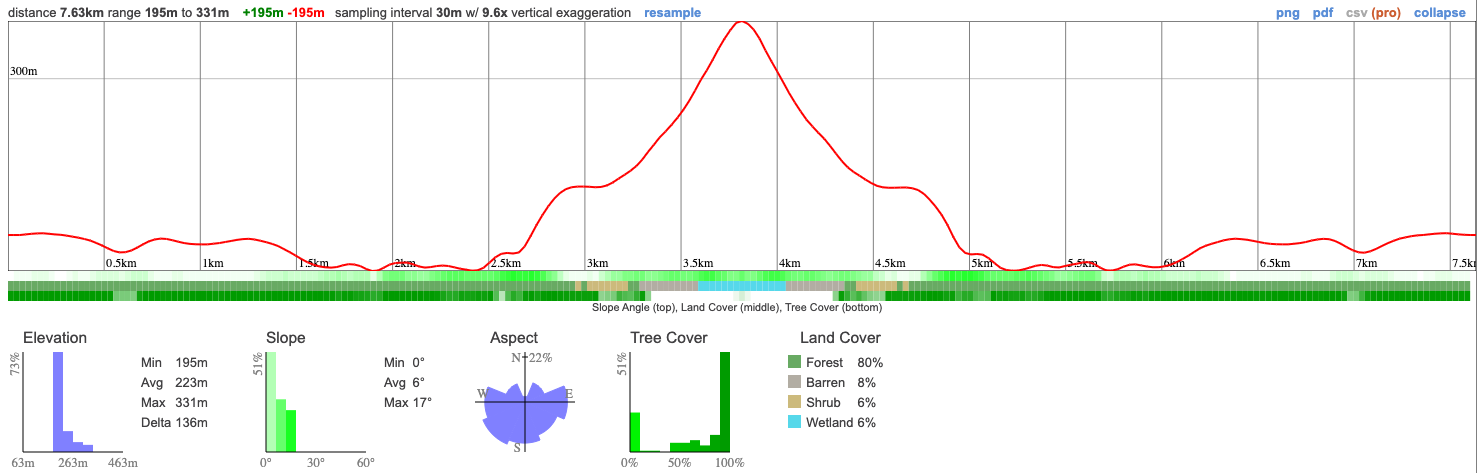
Hike Length: 8km
Terrain: We'll start out in forest and end up walking up a quartzite mountain. The end of this trail is very steep and technical at times with hands-and-knees climbing and careful maneuvering around large rocks. This requires you to place your feet carefully, so we'll be tackling this section slowly.
Estimated time to complete: 5 hours with breaks and exploration time. We'll eat lunch on the top of the mountain!
05:50 - Meet at the PetroCanada next to Keele Station. There's a Tims around the corner if you want to grab breakfast. TRANSPORT WILL LEAVE AT 06:00 whether you are here or not so you must be there on time.
06:00 - Transport leaves.
11:00 - Arrival at Killarney and hike the Crack, eating lunch when we get to the top.
16:30 - End hike, leave Killarney
20:30 - Anticipated return to Keele Station
This custom map is georeferenced, meaning it will show you where you are on the map in the right software and lays out the rough path that we’ll be following. It’s opened with the Avenza app which must be downloaded and installed in advance of the adventure.
You should also download the What3words app - this makes it easy to share and find locations in the unlikely event that you get lost.
Packing list
Have any questions? Ask us on the Discord!
We'll stop for a toilet break on the route to Killarney but please eat breakfast before leaving or bring some with you.
Bring a packed lunch, snacks and at least a 2 litres of water for the hike.
A Daily Vehicle Permit for the Crack, bookable online for self-drivers. Needs to be booked 5 days in advance by 7pm on October 6th.
You should read all of the instructions in here carefully and make sure you've downloaded and installed the map! It's important that you listen to the guides and follow their instructions at all times.
Hiking injuries: Wear appropriate footwear (ankle high hiking boots) and hike within your abilities. If you need extra support, bring hiking poles.
Getting lost: All hikers must remain with the group at all times. If you do find yourself lost at any point, stay where you are and call for help. If you have a whistle, bring it.
Trail conditions: Trails may be muddy and quartzite mountains have poor traction, ensure you're wearing proper footwear with tread and ankle support.
Falling from heights: There are some steep cliffs on this trail, don't get too close to any.
Wildlife: Bears and moose are not uncommon around this area. If you come across a larger animal, back away and alert the group. Your guide will give you further instructions.
Ticks - Tick season has started again and they're active in the area we're visiting. Black Legged Ticks have the risk of carrying Lyme disease so it's important that you check yourself thoroughly after each hike. You're also recommended to have your legs covered so it's harder for them to latch on.
We like to share some of the indigenous background of the areas we visit because these territories have rich histories that are easy to overlook. Indigenous communities have a connection to and respect for the land that has largely been lost since European settlement. As we strive to form a deeper connection with the land, we have much to learn from these communities. I use the Native Land map to learn more about these areas and find that developing a richer understanding leads to a greater enjoyment of the adventures.
Killarney is on the traditional territory of the Anishnaabe and Missisaugas.
Join us for an unforgettable day trip to stunning Killarney Provincial Park, where we'll embark on one of Ontario's most iconic hikes - The Crack. This challenging and technical hike has absolutely incredible views from the top.
As we venture into the heart of Killarney, the rugged beauty of the Canadian Shield will surround us, with ancient rocks and lush forests setting the scene. The Crack Trail, famous for its unique geological features, will see us ascending through rocky crevices, traversing steep inclines to reach the awe-inspiring summit.
Throughout the hike, we'll be treated to panoramic views of the pristine wilderness, and surrounding lakes. The sheer beauty and untamed landscape make every step of this journey more rewarding.
The Crack trail is a physically demanding hike, and participants should be prepared for the strenuous terrain. However, with a bit of determination and enthusiasm, members with a decent level of fitness and no injuries will be more than capable of taking on this thrilling adventure.
This will be a long day (it's a 4hr drive to Killarney) but it's a real bucket list experience that's worth the trek.
Hike Length: 8km
Terrain: We'll start out in forest and end up walking up a quartzite mountain. The end of this trail is very steep and technical at times with hands-and-knees climbing and careful maneuvering around large rocks. This requires you to place your feet carefully, so we'll be tackling this section slowly.
Estimated time to complete: 5 hours with breaks and exploration time. We'll eat lunch on the top of the mountain!
05:50 - Meet at the PetroCanada next to Keele Station. There's a Tims around the corner if you want to grab breakfast. TRANSPORT WILL LEAVE AT 06:00 whether you are here or not so you must be there on time.
06:00 - Transport leaves.
11:00 - Arrival at Killarney and hike the Crack, eating lunch when we get to the top.
16:30 - End hike, leave Killarney
20:30 - Anticipated return to Keele Station
This custom map is georeferenced, meaning it will show you where you are on the map in the right software and lays out the rough path that we’ll be following. It’s opened with the Avenza app which must be downloaded and installed in advance of the adventure.
You should also download the What3words app - this makes it easy to share and find locations in the unlikely event that you get lost.
Packing list
Have any questions? Ask us on the Discord!
We'll stop for a toilet break on the route to Killarney but please eat breakfast before leaving or bring some with you.
Bring a packed lunch, snacks and at least a 2 litres of water for the hike.
A Daily Vehicle Permit for the Crack, bookable online for self-drivers. Needs to be booked 5 days in advance by 7pm on October 6th.
You should read all of the instructions in here carefully and make sure you've downloaded and installed the map! It's important that you listen to the guides and follow their instructions at all times.
Hiking injuries: Wear appropriate footwear (ankle high hiking boots) and hike within your abilities. If you need extra support, bring hiking poles.
Getting lost: All hikers must remain with the group at all times. If you do find yourself lost at any point, stay where you are and call for help. If you have a whistle, bring it.
Trail conditions: Trails may be muddy and quartzite mountains have poor traction, ensure you're wearing proper footwear with tread and ankle support.
Falling from heights: There are some steep cliffs on this trail, don't get too close to any.
Wildlife: Bears and moose are not uncommon around this area. If you come across a larger animal, back away and alert the group. Your guide will give you further instructions.
Ticks - Tick season has started again and they're active in the area we're visiting. Black Legged Ticks have the risk of carrying Lyme disease so it's important that you check yourself thoroughly after each hike. You're also recommended to have your legs covered so it's harder for them to latch on.
We like to share some of the indigenous background of the areas we visit because these territories have rich histories that are easy to overlook. Indigenous communities have a connection to and respect for the land that has largely been lost since European settlement. As we strive to form a deeper connection with the land, we have much to learn from these communities. I use the Native Land map to learn more about these areas and find that developing a richer understanding leads to a greater enjoyment of the adventures.
Killarney is on the traditional territory of the Anishnaabe and Missisaugas.