Jacob's Ladder is justifiably one of the more popular hikes that's relatively close to Toronto but it's not over-run with people. This is a relatively easy hike. We'll be hiking 8km and it's suitable for anyone with a moderate level of fitness. We'll hike across fields, through forest and up the cliffs to take in the views. We end up at Jacob's Ladder, a staircase leading through the iconic cliff face at the top of the climb.
Hike Length: 8km
Terrain: This is a pretty easy hike on well trodden paths alongside fields, through the woods and at one point, up a steel staircase. There are a couple of steeper sections that we can take slowly. There's been a lot of rain lately so it's likely the ground could be fairly muddy.
Estimated time to complete: 3.5 hours with breaks and exploration time
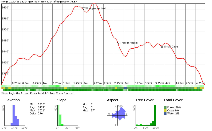
Note that while this looks steep, the total elevation gain is relatively modest and the slope chart isn't too aggressive!
10:30: Shuttle leaves from the Petrocanada next to Keele Subway Station
11:45: Meet self-drivers at parking lot
12:00 - 15:30: Hike, stopping for lunch en route
15:30: Return to Toronto
17:00: Anticipated return to Keele subway station
This custom map is georeferenced, meaning it will show you where you are on the map in the right software and lays out the rough path that we’ll be following. It’s opened with the Avenza app which must be downloaded and installed in advance of the adventure.
You should also download the What3words app - this makes it easy to share and find locations in the unlikely event that you get lost.
Self drivers will need to book a Daily Vehicle Permit for Mono Cliffs Provincial Park from 12-4pm here
Hiking injuries - Wear appropriate footwear (ankle high hiking boots) and hike within your abilities. If you need extra support, bring hiking poles.
Sunburn/heat stroke/dehydration - Wear sunscreen and a sun hat. Make sure that you hydrate regularly
Mono is the traditional territory of the Anishinaabe, Haudenosaunee, and Wendat peoples. These Indigenous communities have a long history in the region, dating back thousands of years.
The Anishinaabe people, also known as the Ojibwe, Potawatomi, and Odawa, were the first inhabitants of the area. They were semi-nomadic, and their livelihood depended on hunting, fishing, and gathering. They had a deep understanding of the land and its resources, and their culture was centered around a respect for nature and the natural world.
In the early 17th century, the Haudenosaunee people, also known as the Iroquois Confederacy, began to move into the region, displacing some of the Anishinaabe communities. The Haudenosaunee were also semi-nomadic, and their culture was based on agriculture, hunting, and fishing. They had a sophisticated political and social system and were known for their longhouses and wampum belts.
In the mid-17th century, the Wendat people, also known as the Huron, were forced to flee their homeland in what is now the Georgian Bay area due to conflicts with the Haudenosaunee. Some of these Wendat refugees settled in the area, where they established new communities.
Over time, the Indigenous communities were impacted by European colonization and settlement, including the imposition of residential schools and the loss of land and resources. Today, there are ongoing efforts to reclaim Indigenous knowledge, language, and culture and to work towards reconciliation with Indigenous peoples in Canada.
Jacob's Ladder is justifiably one of the more popular hikes that's relatively close to Toronto but it's not over-run with people. This is a relatively easy hike. We'll be hiking 8km and it's suitable for anyone with a moderate level of fitness. We'll hike across fields, through forest and up the cliffs to take in the views. We end up at Jacob's Ladder, a staircase leading through the iconic cliff face at the top of the climb.
Hike Length: 8km
Terrain: This is a pretty easy hike on well trodden paths alongside fields, through the woods and at one point, up a steel staircase. There are a couple of steeper sections that we can take slowly. There's been a lot of rain lately so it's likely the ground could be fairly muddy.
Estimated time to complete: 3.5 hours with breaks and exploration time
Note that while this looks steep, the total elevation gain is relatively modest and the slope chart isn't too aggressive!
10:30: Shuttle leaves from the Petrocanada next to Keele Subway Station
11:45: Meet self-drivers at parking lot
12:00 - 15:30: Hike, stopping for lunch en route
15:30: Return to Toronto
17:00: Anticipated return to Keele subway station
This custom map is georeferenced, meaning it will show you where you are on the map in the right software and lays out the rough path that we’ll be following. It’s opened with the Avenza app which must be downloaded and installed in advance of the adventure.
You should also download the What3words app - this makes it easy to share and find locations in the unlikely event that you get lost.
Self drivers will need to book a Daily Vehicle Permit for Mono Cliffs Provincial Park from 12-4pm here
Hiking injuries - Wear appropriate footwear (ankle high hiking boots) and hike within your abilities. If you need extra support, bring hiking poles.
Sunburn/heat stroke/dehydration - Wear sunscreen and a sun hat. Make sure that you hydrate regularly
Mono is the traditional territory of the Anishinaabe, Haudenosaunee, and Wendat peoples. These Indigenous communities have a long history in the region, dating back thousands of years.
The Anishinaabe people, also known as the Ojibwe, Potawatomi, and Odawa, were the first inhabitants of the area. They were semi-nomadic, and their livelihood depended on hunting, fishing, and gathering. They had a deep understanding of the land and its resources, and their culture was centered around a respect for nature and the natural world.
In the early 17th century, the Haudenosaunee people, also known as the Iroquois Confederacy, began to move into the region, displacing some of the Anishinaabe communities. The Haudenosaunee were also semi-nomadic, and their culture was based on agriculture, hunting, and fishing. They had a sophisticated political and social system and were known for their longhouses and wampum belts.
In the mid-17th century, the Wendat people, also known as the Huron, were forced to flee their homeland in what is now the Georgian Bay area due to conflicts with the Haudenosaunee. Some of these Wendat refugees settled in the area, where they established new communities.
Over time, the Indigenous communities were impacted by European colonization and settlement, including the imposition of residential schools and the loss of land and resources. Today, there are ongoing efforts to reclaim Indigenous knowledge, language, and culture and to work towards reconciliation with Indigenous peoples in Canada.