We’re keeping it local this weekend with a Navigation class in High Park, taught by former army instructor, Captain Robert Buckingham. Those of you who attended our winter camping in Temagami already know Rob as an expert survivalist and navigation is his real forte.
We’re bringing maps and compasses to teach you the fundamentals of navigation in preparation for next week when we’ll conduct a real world exercise. By the end of the session you'll feel confident reading a map and figuring out how to use a compass.
Once the lesson is done, we’re going to head down the street to a local favourite, Mugshots for some food and drinks. Non-alcoholic and vegan options are available.
There won't be any hiking during the lesson. Some of the subject matter we'll cover:
13:30 - Meet at the sheltered picnic area opposite the baseball diamond and just past the swimming pool. The closest subway is High Park - it's approx a 15 minute walk from the subway and there is a bikeshare stop directly opposite the picnic spot. N.B that there is no car access to High Park during the weekend.
13:30-16:30 - Navigation course (precise timing may vary)
16:30 - Head to Mugshots
This custom map is georeferenced, meaning it will show you where you are on the map in the right software and lays out the rough path that we’ll be following. It’s opened with the Avenza app which must be downloaded and installed in advance of the adventure.
You should also download the What3words app - this makes it easy to share and find locations in the unlikely event that you get lost.
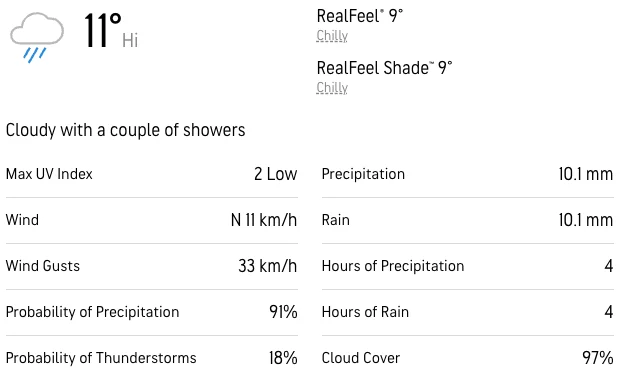
- Pack warm clothing - we won't be moving much and we don't want you getting cold.
- A pen and notebook to create a route-card (we'll explain that Sunday)
- If you have a compass of your own, please bring this along!
We'll be heading for food and drink at Mugshots after the lesson.
We'll be providing maps and compasses.
Before European settlement, the land was inhabited and managed by the Wendat, the Haudenosaunee, the Anishinaabe, and the Mississaugas of the Credit. These communities lived more harmoniously with the land, utilizing practices such as controlled burns to maintain the ecosystem and promote the growth of native species like the Big Bluestem grass.
The park's rare oak savannah ecology is a direct result of these Indigenous land management practices. The Black Oak Savannah in High Park is a living symbol of Indigenous caretaking and stewardship, showcasing the long legacy of these practices in the park. The Indigenous peoples of the area harvested resources and maintained the ecosystem through a relationship of reciprocity with the land, which included the careful management of plant species and the creation and maintenance of trails and water routes.
Despite the impact of European settlement, which led to the suppression of wildfires and controlled burns, and increased development that altered the natural landscape, the legacy of Indigenous stewardship remains evident in High Park. Today, efforts to acknowledge and honor this history include land acknowledgments, the reintroduction of prescribed burns as a forest management tool, and the engagement with Indigenous partners to guide stewardship work in the park.
We're visiting at a particularly interesting time because the prescribed burn was carried out just this week, the signs of which will still be visible.
We’re keeping it local this weekend with a Navigation class in High Park, taught by former army instructor, Captain Robert Buckingham. Those of you who attended our winter camping in Temagami already know Rob as an expert survivalist and navigation is his real forte.
We’re bringing maps and compasses to teach you the fundamentals of navigation in preparation for next week when we’ll conduct a real world exercise. By the end of the session you'll feel confident reading a map and figuring out how to use a compass.
Once the lesson is done, we’re going to head down the street to a local favourite, Mugshots for some food and drinks. Non-alcoholic and vegan options are available.
There won't be any hiking during the lesson. Some of the subject matter we'll cover:
13:30 - Meet at the sheltered picnic area opposite the baseball diamond and just past the swimming pool. The closest subway is High Park - it's approx a 15 minute walk from the subway and there is a bikeshare stop directly opposite the picnic spot. N.B that there is no car access to High Park during the weekend.
13:30-16:30 - Navigation course (precise timing may vary)
16:30 - Head to Mugshots
This custom map is georeferenced, meaning it will show you where you are on the map in the right software and lays out the rough path that we’ll be following. It’s opened with the Avenza app which must be downloaded and installed in advance of the adventure.
You should also download the What3words app - this makes it easy to share and find locations in the unlikely event that you get lost.
- Pack warm clothing - we won't be moving much and we don't want you getting cold.
- A pen and notebook to create a route-card (we'll explain that Sunday)
- If you have a compass of your own, please bring this along!
We'll be heading for food and drink at Mugshots after the lesson.
We'll be providing maps and compasses.
Before European settlement, the land was inhabited and managed by the Wendat, the Haudenosaunee, the Anishinaabe, and the Mississaugas of the Credit. These communities lived more harmoniously with the land, utilizing practices such as controlled burns to maintain the ecosystem and promote the growth of native species like the Big Bluestem grass.
The park's rare oak savannah ecology is a direct result of these Indigenous land management practices. The Black Oak Savannah in High Park is a living symbol of Indigenous caretaking and stewardship, showcasing the long legacy of these practices in the park. The Indigenous peoples of the area harvested resources and maintained the ecosystem through a relationship of reciprocity with the land, which included the careful management of plant species and the creation and maintenance of trails and water routes.
Despite the impact of European settlement, which led to the suppression of wildfires and controlled burns, and increased development that altered the natural landscape, the legacy of Indigenous stewardship remains evident in High Park. Today, efforts to acknowledge and honor this history include land acknowledgments, the reintroduction of prescribed burns as a forest management tool, and the engagement with Indigenous partners to guide stewardship work in the park.
We're visiting at a particularly interesting time because the prescribed burn was carried out just this week, the signs of which will still be visible.
