It's perfect weather for a day on the river. We're meeting at Kingsmill Park North under Old Mill Station where we'll get fitted for lifejackets and grab our canoes. Ryan will give those who need it a quick lesson then we'll lazily explore the Humber River. Keep your eyes open for kingfishers, cormorants, beavers and even deer.
After a couple of hours on the river, we'll set up in the park for a picnic. Bring food, drinks, games and picnic blankets to hang out for as much of the afternoon as you feel like.
There's a total of about 6km of paddling available to you. My favourite route is to go south, exploring the marshes as you go. We'll stick together as a group the whole time.
N.B. You should not go beyond the Humber Bay Bridge at the mouth of the Humber - conditions get considerably more choppy beyond that.
10:15 - Meet at Humber River Adventures - it's easily accessible by public transport and bikeshare. Sign in, get equipment.
10:30-12:30 - Paddle
12:30 onwards - Picnic
This custom map is georeferenced, meaning it will show you where you are on the map in the right software and lays out the rough path that we’ll be following. It’s opened with the Avenza app which must be downloaded and installed in advance of the adventure.
You should also download the What3words app - this makes it easy to share and find locations in the unlikely event that you get lost.
You can leave additional stuff in an (unattended) trailer on site.
You'll be getting a tandem canoe, paddle, PFD and safety kit. Feel free to bring your own PFD.
We will all wear lifejackets (PFDs) at all times.
Before we start, Ryan or on-site staff will check that it is fitted properly. When you pull on it, it should not be able to come above your head
Please notify Ryan if you can't swim.
This is helpful so we can keep an eye on you, be extra careful with your PFD and pair you with a strong paddler.
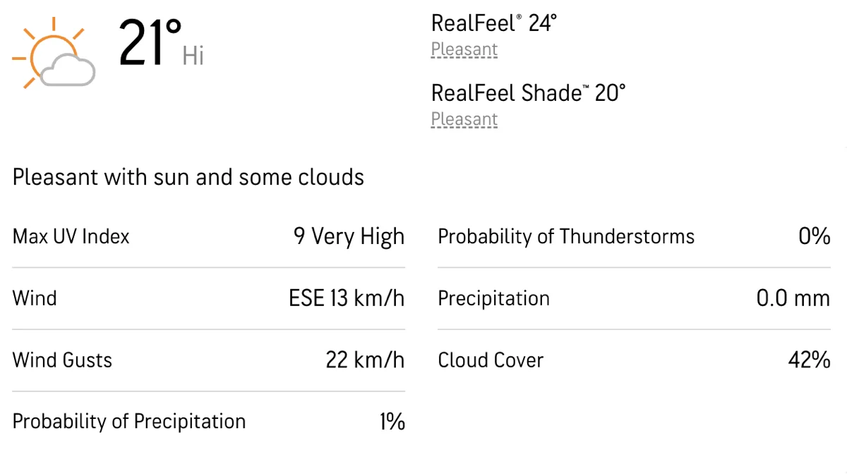
Heat exposure
It will be a hot day so ensure that you're wearing sunscreen, a sun hat and drink plenty of fluids.
N.B. You should not go beyond the Humber Bay Bridge at the mouth of the Humber - conditions get considerably more choppy beyond that.
We like to share some of the indigenous background of the areas we visit because these territories have rich histories that are easy to overlook. Indigenous communities have a connection to and respect for the land that has largely been lost since European settlement. As we strive to form a deeper connection with the land, we have much to learn from these communities. You can use the Native Land map to learn more about these areas.
The Humber has a particularly long and varied indigenous history, groups who maintain connections to the land include:
It's perfect weather for a day on the river. We're meeting at Kingsmill Park North under Old Mill Station where we'll get fitted for lifejackets and grab our canoes. Ryan will give those who need it a quick lesson then we'll lazily explore the Humber River. Keep your eyes open for kingfishers, cormorants, beavers and even deer.
After a couple of hours on the river, we'll set up in the park for a picnic. Bring food, drinks, games and picnic blankets to hang out for as much of the afternoon as you feel like.
There's a total of about 6km of paddling available to you. My favourite route is to go south, exploring the marshes as you go. We'll stick together as a group the whole time.
N.B. You should not go beyond the Humber Bay Bridge at the mouth of the Humber - conditions get considerably more choppy beyond that.
10:15 - Meet at Humber River Adventures - it's easily accessible by public transport and bikeshare. Sign in, get equipment.
10:30-12:30 - Paddle
12:30 onwards - Picnic
This custom map is georeferenced, meaning it will show you where you are on the map in the right software and lays out the rough path that we’ll be following. It’s opened with the Avenza app which must be downloaded and installed in advance of the adventure.
You should also download the What3words app - this makes it easy to share and find locations in the unlikely event that you get lost.
You can leave additional stuff in an (unattended) trailer on site.
You'll be getting a tandem canoe, paddle, PFD and safety kit. Feel free to bring your own PFD.
We will all wear lifejackets (PFDs) at all times.
Before we start, Ryan or on-site staff will check that it is fitted properly. When you pull on it, it should not be able to come above your head
Please notify Ryan if you can't swim.
This is helpful so we can keep an eye on you, be extra careful with your PFD and pair you with a strong paddler.
Heat exposure
It will be a hot day so ensure that you're wearing sunscreen, a sun hat and drink plenty of fluids.
N.B. You should not go beyond the Humber Bay Bridge at the mouth of the Humber - conditions get considerably more choppy beyond that.
We like to share some of the indigenous background of the areas we visit because these territories have rich histories that are easy to overlook. Indigenous communities have a connection to and respect for the land that has largely been lost since European settlement. As we strive to form a deeper connection with the land, we have much to learn from these communities. You can use the Native Land map to learn more about these areas.
The Humber has a particularly long and varied indigenous history, groups who maintain connections to the land include:
.webp)