.webp)
One of the most popular adventures we've ever organized returns! Last year's visit was unbelievably beautiful and quiet. While the crowds flock to Algonquin to view fall colours, Frontenac is where it's really at. East of the city with a fraction of the visitors, Frontenac is a unique landscape that is every bit as beautiful as the more famous parks but with a more diverse terrain. We'll be walking across beaver dams, over granite barrens and through golden forest.
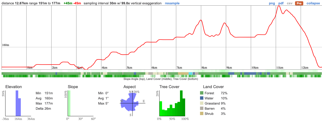
Hike Length: 13km
Terrain: A fairly easy hike with little elevation but across rock, dirt and over small wooden trails
Estimated time to complete: 5 hours with breaks and exploration time.
06:50 - Those leaving from Keele meet at the PetroCanada by Keele Station
07:00: Shuttle leaves from PetroCanada at Keele Station. Please note that we leave dead on 7am and can't wait for latecomers.
10:00 - Meet self-drivers at the park office. Self-drivers - please note that you will need to meet us there on time, it's recommended that you arrive a few minutes early so you don't miss the group.
10:30 - 15:30 - Hike!
19:30 - Anticipated return to Toronto
This custom map is georeferenced, meaning it will show you where you are on the map in the right software and lays out the rough path that we’ll be following. It’s opened with the Avenza app which must be downloaded and installed in advance of the adventure.
You should also download the What3words app - this makes it easy to share and find locations in the unlikely event that you get lost.
Remember to pack a lunch, some snacks and at least 1l (ideally 2l if hot) of water.
Self drivers will need to reserve a Daily Vehicle Permit for $15.50, 5 days in advance here.
Hiking injuries- Make sure that you're wearing appropriate footwear!
Ticks - Black legged ticks may be present in the area. You should wear pants rather than shorts to prevent them latching on and lighter colours make it easier to spot them and keep you more cool. There's no need to worry about ticks if we take a few precautions and we'll talk about doing a tick check after the hike just to confirm we haven't picked any up. You can learn more here
We like to share some of the indigenous background of the areas we visit because these territories have rich histories that are easy to overlook. Indigenous communities have a connection to and respect for the land that has largely been lost since European settlement. As we strive to form a deeper connection with the land, we have much to learn from these communities. I use the Native Land map to learn more about these areas and find that developing a richer understanding leads to a greater enjoyment of the adventures.
The area was likely used for hunting, fishing, and gathering, as well as possibly for seasonal or semi-permanent settlements. Various waterways, such as those connected to the Great Lakes, were vital for transportation and trade among Indigenous communities.
The arrival of European settlers in the 17th and 18th centuries significantly impacted Indigenous populations through disease, displacement, and conflict. Treaties were often signed under unequal conditions, leading to the loss of traditional lands and ways of life for Indigenous communities.
Nations who still have connections to the area are the Missisaugas of the Credit First Nation the Huron Wendat and the Anishnabe.
One of the most popular adventures we've ever organized returns! Last year's visit was unbelievably beautiful and quiet. While the crowds flock to Algonquin to view fall colours, Frontenac is where it's really at. East of the city with a fraction of the visitors, Frontenac is a unique landscape that is every bit as beautiful as the more famous parks but with a more diverse terrain. We'll be walking across beaver dams, over granite barrens and through golden forest.
Hike Length: 13km
Terrain: A fairly easy hike with little elevation but across rock, dirt and over small wooden trails
Estimated time to complete: 5 hours with breaks and exploration time.
06:50 - Those leaving from Keele meet at the PetroCanada by Keele Station
07:00: Shuttle leaves from PetroCanada at Keele Station. Please note that we leave dead on 7am and can't wait for latecomers.
10:00 - Meet self-drivers at the park office. Self-drivers - please note that you will need to meet us there on time, it's recommended that you arrive a few minutes early so you don't miss the group.
10:30 - 15:30 - Hike!
19:30 - Anticipated return to Toronto
This custom map is georeferenced, meaning it will show you where you are on the map in the right software and lays out the rough path that we’ll be following. It’s opened with the Avenza app which must be downloaded and installed in advance of the adventure.
You should also download the What3words app - this makes it easy to share and find locations in the unlikely event that you get lost.
Check back to see how the weather is developing.
Check back to see how the weather is developing.
Remember to pack a lunch, some snacks and at least 1l (ideally 2l if hot) of water.
Self drivers will need to reserve a Daily Vehicle Permit for $15.50, 5 days in advance here.
Hiking injuries- Make sure that you're wearing appropriate footwear!
Ticks - Black legged ticks may be present in the area. You should wear pants rather than shorts to prevent them latching on and lighter colours make it easier to spot them and keep you more cool. There's no need to worry about ticks if we take a few precautions and we'll talk about doing a tick check after the hike just to confirm we haven't picked any up. You can learn more here
We like to share some of the indigenous background of the areas we visit because these territories have rich histories that are easy to overlook. Indigenous communities have a connection to and respect for the land that has largely been lost since European settlement. As we strive to form a deeper connection with the land, we have much to learn from these communities. I use the Native Land map to learn more about these areas and find that developing a richer understanding leads to a greater enjoyment of the adventures.
The area was likely used for hunting, fishing, and gathering, as well as possibly for seasonal or semi-permanent settlements. Various waterways, such as those connected to the Great Lakes, were vital for transportation and trade among Indigenous communities.
The arrival of European settlers in the 17th and 18th centuries significantly impacted Indigenous populations through disease, displacement, and conflict. Treaties were often signed under unequal conditions, leading to the loss of traditional lands and ways of life for Indigenous communities.
Nations who still have connections to the area are the Missisaugas of the Credit First Nation the Huron Wendat and the Anishnabe.