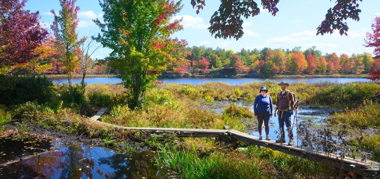
One of the most popular adventures we've ever organized returns! Last year's visit was unbelievably beautiful and quiet. While the crowds flock to Algonquin to view fall colours, Frontenac is where it's really at. East of the city with a fraction of the visitors, Frontenac is a unique landscape that is every bit as beautiful as the more famous parks but with a more diverse terrain. We'll be walking across beaver dams, over granite barrens and through golden forest.
The hike itself is a relatively easy 9km hike but super interesting due to the natural features along the way and some beautiful look outs. This is a long day so we'll be leaving early. You won't want to miss it.
Self drivers please note - Frontenac is at least a 3hr drive and requires a $15 day pass - you're strongly recommended to choose the transport option for this trip. The day pass is included for anyone riding in the van.
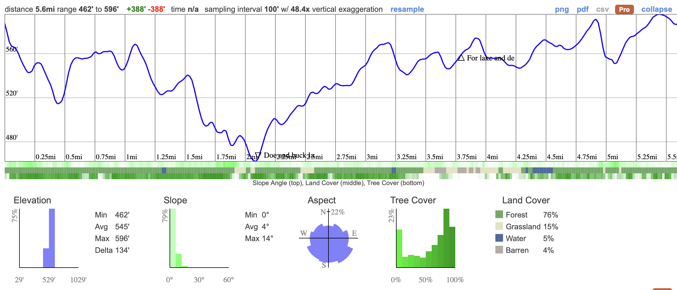
The 9 km Cedar Lake Trail in Frontenac Provincial Park is a moderate loop with about 200 m of elevation gain, weaving through forests, rocky ridges, and lakeshore lookouts. The trail is well marked but has some roots, rocks, and muddy patches that keep things interesting. You will pass through quiet stretches in the woods, climb over open granite outcrops, and enjoy views of Cedar Lake, making it a fun and rewarding hike without being too tough. The trail should take us 4.5 hours to complete including time for lots o breaks and photo time.
06:50 - Meet at the PetroCanada next to Keele Station. There's a Tims around the corner if you want to grab breakfast. THE BUS WILL LEAVE AT 07:00 whether you are here or not so you must be there on time.
07:00 - Bus leaves
10:30 - Meet self drivers at Arab Lake Parking Lot
10:30 - 15:00 - Hike, eating lunch en route
19:00 - Anticipated return to Toronto
This custom map is georeferenced, meaning it will show you where you are on the map in the right software and lays out the rough path that we’ll be following. It’s opened with the Avenza app which must be downloaded and installed in advance of the adventure.
You should also download the What3words app - this makes it easy to share and find locations in the unlikely event that you get lost.
Packing list
Have any questions? Ask us on the Discord!
Grab breakfast before you go. There's a Tims around the corner from our meet-up point.
Bring a packed lunch, snacks and at least a 2 litres of water for the hike. We also reccomend electolyte drinks for hot days!
Self-drivers will need to purchase a Daily Vehicle Permit here five days in advance of the trip.
You should read all of the instructions in here carefully and make sure you've downloaded and installed the map! It's important that you listen to the guides and follow their instructions at all times.
Hiking injuries: Wear appropriate footwear (ankle high hiking boots) and hike within your abilities. If you need extra support, bring hiking poles.
Getting lost: All hikers must remain with the group at all times. If you do find yourself lost at any point, stay where you are and call for help. If you have a whistle, bring it.
Trail conditions: Trails may be muddy, ensure you're wearing proper footwear with tread and ankle support.
We like to share some of the indigenous background of the areas we visit because these territories have rich histories that are easy to overlook. Indigenous communities have a connection to and respect for the land that has largely been lost since European settlement. As we strive to form a deeper connection with the land, we have much to learn from these communities. We use the Native Land map to learn more about these areas and find that developing a richer understanding leads to a greater enjoyment of the adventures.
One of the most popular adventures we've ever organized returns! Last year's visit was unbelievably beautiful and quiet. While the crowds flock to Algonquin to view fall colours, Frontenac is where it's really at. East of the city with a fraction of the visitors, Frontenac is a unique landscape that is every bit as beautiful as the more famous parks but with a more diverse terrain. We'll be walking across beaver dams, over granite barrens and through golden forest.
The hike itself is a relatively easy 9km hike but super interesting due to the natural features along the way and some beautiful look outs. This is a long day so we'll be leaving early. You won't want to miss it.
Self drivers please note - Frontenac is at least a 3hr drive and requires a $15 day pass - you're strongly recommended to choose the transport option for this trip. The day pass is included for anyone riding in the van.
The 9 km Cedar Lake Trail in Frontenac Provincial Park is a moderate loop with about 200 m of elevation gain, weaving through forests, rocky ridges, and lakeshore lookouts. The trail is well marked but has some roots, rocks, and muddy patches that keep things interesting. You will pass through quiet stretches in the woods, climb over open granite outcrops, and enjoy views of Cedar Lake, making it a fun and rewarding hike without being too tough. The trail should take us 4.5 hours to complete including time for lots o breaks and photo time.
06:50 - Meet at the PetroCanada next to Keele Station. There's a Tims around the corner if you want to grab breakfast. THE BUS WILL LEAVE AT 07:00 whether you are here or not so you must be there on time.
07:00 - Bus leaves
10:30 - Meet self drivers at Arab Lake Parking Lot
10:30 - 15:00 - Hike, eating lunch en route
19:00 - Anticipated return to Toronto
This custom map is georeferenced, meaning it will show you where you are on the map in the right software and lays out the rough path that we’ll be following. It’s opened with the Avenza app which must be downloaded and installed in advance of the adventure.
You should also download the What3words app - this makes it easy to share and find locations in the unlikely event that you get lost.
Packing list
Have any questions? Ask us on the Discord!
Grab breakfast before you go. There's a Tims around the corner from our meet-up point.
Bring a packed lunch, snacks and at least a 2 litres of water for the hike. We also reccomend electolyte drinks for hot days!
Self-drivers will need to purchase a Daily Vehicle Permit here five days in advance of the trip.
You should read all of the instructions in here carefully and make sure you've downloaded and installed the map! It's important that you listen to the guides and follow their instructions at all times.
Hiking injuries: Wear appropriate footwear (ankle high hiking boots) and hike within your abilities. If you need extra support, bring hiking poles.
Getting lost: All hikers must remain with the group at all times. If you do find yourself lost at any point, stay where you are and call for help. If you have a whistle, bring it.
Trail conditions: Trails may be muddy, ensure you're wearing proper footwear with tread and ankle support.
We like to share some of the indigenous background of the areas we visit because these territories have rich histories that are easy to overlook. Indigenous communities have a connection to and respect for the land that has largely been lost since European settlement. As we strive to form a deeper connection with the land, we have much to learn from these communities. We use the Native Land map to learn more about these areas and find that developing a richer understanding leads to a greater enjoyment of the adventures.