Join us for a day hike along one of the most iconic sections of the Bruce Trail at Forks of the Credit Provincial Park. Nestled in a stunning landscape, this 9km trail has a blend of natural beauty and accessible hiking. It's moderately challenging but suitable for anyone who feels they're in decent shape.
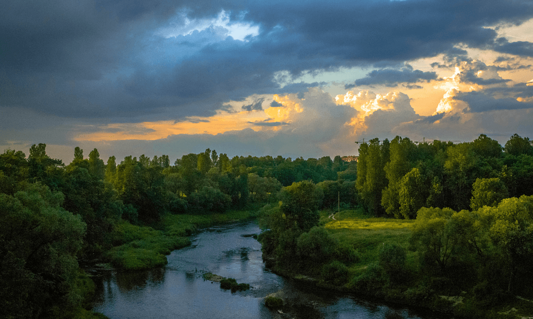
Starting our day on a well-trodden path, we'll navigate through woodlands and gentle slopes, taking in views of the Credit River as it winds through the valley. The trail is perfect for hikers of all abilities, while still providing engaging scenery and varied terrain.
Though a popular spot, it should be a very peaceful hike. Along the way, we'll discover why it's a favourite for many, with scenic overlooks and a path that traces the riverside. We'll pause for lunch at a lookout to refuel.
The hike is just over an hour away so it's pretty accessible. Whether you're a seasoned hiker or new to the trails, this day hike offers a taste of why people love the Bruce Trail.
Hike Length: 9km
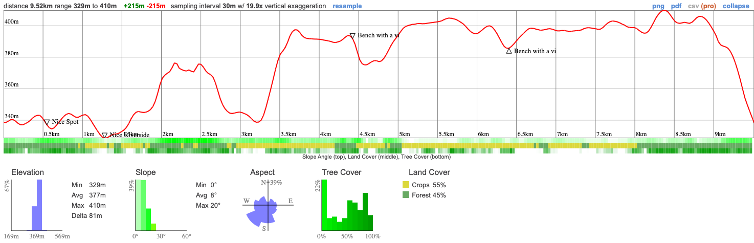
Terrain: We'll be on well trodden trails through the forest and woods. There are a couple of steeper spots with a total ascent of 259m. It's moderately challenging but should be well within the capabilities of anybody who considers themselves fit.
Estimated time to complete: 4 hours with breaks and exploration time.
08:50: Those taking the van meet at the Petrocanada next to Keele Subway Station. Driving to the shuttle location? There's free parking here.
09:00: Shuttle leaves. Please note that out of respect for each other, we leave dead on time and can not wait for latecomers.
10:00: Meet self-drivers at trail head. Navigate to Forks of the Credit Provincial Park
10:15 - 14:30: Hike, stopping for lunch en route
16:00: Anticipated return to Keele subway station
This custom map is georeferenced, meaning it will show you where you are on the map in the right software and lays out the rough path that we’ll be following. It’s opened with the Avenza app which must be downloaded and installed in advance of the adventure.
You should also download the What3words app - this makes it easy to share and find locations in the unlikely event that you get lost.
Remember to pack a lunch, some snacks and at least 1l of water.
You'll need to reserve a Daily Vehicle Permit 5 days in advance at a cost of $18 to join this adventure. You'll need the full day permit, available for purchase from 7am on August 14th here.
Hiking injuries - Wear appropriate footwear and hike within your abilities. If you need extra support, bring hiking poles.
Sunburn/heat stroke/dehydration - Wear sunscreen and a sun hat. Make sure that you hydrate regularly
Ticks - Black legged ticks are present in the area. You should wear pants rather than shorts to prevent them latching on and lighter colours make it easier to spot them and keep you more cool. There's no need to worry about ticks if we take a few precautions and we'll talk about doing a tick check after the hike just to confirm we haven't picked any up. You can learn more here
We like to share some of the indigenous background of the areas we visit because these territories have rich histories that are easy to overlook. Indigenous communities have a connection to and respect for the land that has largely been lost since European settlement. As we strive to form a deeper connection with the land, we have much to learn from these communities. I use the Native Land map to learn more about these areas and find that developing a richer understanding leads to a greater enjoyment of the adventures.
Nashville Conservation Reserve falls within the traditional area of the Petun people, also known as the Tobacco people and are one of the people among the Iroquois common in Ontario. There were probably only 8000 members prior to the arrival of European settlers. When those settlers arrived, that population was decimated by the disease that they brought.
Other, larger nations who still have connections to the area are the Missisaugas of the Credit First Nation the Petun, the Anishnabe, Haudenosaunee, and the Huron Wendat.
Join us for a day hike along one of the most iconic sections of the Bruce Trail at Forks of the Credit Provincial Park. Nestled in a stunning landscape, this 9km trail has a blend of natural beauty and accessible hiking. It's moderately challenging but suitable for anyone who feels they're in decent shape.
Starting our day on a well-trodden path, we'll navigate through woodlands and gentle slopes, taking in views of the Credit River as it winds through the valley. The trail is perfect for hikers of all abilities, while still providing engaging scenery and varied terrain.
Though a popular spot, it should be a very peaceful hike. Along the way, we'll discover why it's a favourite for many, with scenic overlooks and a path that traces the riverside. We'll pause for lunch at a lookout to refuel.
The hike is just over an hour away so it's pretty accessible. Whether you're a seasoned hiker or new to the trails, this day hike offers a taste of why people love the Bruce Trail.
Hike Length: 9km
Terrain: We'll be on well trodden trails through the forest and woods. There are a couple of steeper spots with a total ascent of 259m. It's moderately challenging but should be well within the capabilities of anybody who considers themselves fit.
Estimated time to complete: 4 hours with breaks and exploration time.
08:50: Those taking the van meet at the Petrocanada next to Keele Subway Station. Driving to the shuttle location? There's free parking here.
09:00: Shuttle leaves. Please note that out of respect for each other, we leave dead on time and can not wait for latecomers.
10:00: Meet self-drivers at trail head. Navigate to Forks of the Credit Provincial Park
10:15 - 14:30: Hike, stopping for lunch en route
16:00: Anticipated return to Keele subway station
This custom map is georeferenced, meaning it will show you where you are on the map in the right software and lays out the rough path that we’ll be following. It’s opened with the Avenza app which must be downloaded and installed in advance of the adventure.
You should also download the What3words app - this makes it easy to share and find locations in the unlikely event that you get lost.
Remember to pack a lunch, some snacks and at least 1l of water.
You'll need to reserve a Daily Vehicle Permit 5 days in advance at a cost of $18 to join this adventure. You'll need the full day permit, available for purchase from 7am on August 14th here.
Hiking injuries - Wear appropriate footwear and hike within your abilities. If you need extra support, bring hiking poles.
Sunburn/heat stroke/dehydration - Wear sunscreen and a sun hat. Make sure that you hydrate regularly
Ticks - Black legged ticks are present in the area. You should wear pants rather than shorts to prevent them latching on and lighter colours make it easier to spot them and keep you more cool. There's no need to worry about ticks if we take a few precautions and we'll talk about doing a tick check after the hike just to confirm we haven't picked any up. You can learn more here
We like to share some of the indigenous background of the areas we visit because these territories have rich histories that are easy to overlook. Indigenous communities have a connection to and respect for the land that has largely been lost since European settlement. As we strive to form a deeper connection with the land, we have much to learn from these communities. I use the Native Land map to learn more about these areas and find that developing a richer understanding leads to a greater enjoyment of the adventures.
Nashville Conservation Reserve falls within the traditional area of the Petun people, also known as the Tobacco people and are one of the people among the Iroquois common in Ontario. There were probably only 8000 members prior to the arrival of European settlers. When those settlers arrived, that population was decimated by the disease that they brought.
Other, larger nations who still have connections to the area are the Missisaugas of the Credit First Nation the Petun, the Anishnabe, Haudenosaunee, and the Huron Wendat.