
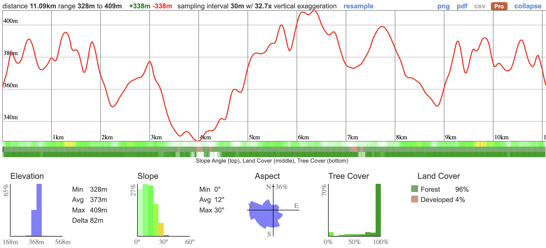
We're visiting Algonquin Highlands to see some of Muskoka's most impressive scenery at the circuit of 5 viewpoints. There's a reason the hike we're doing has viewpoints in the title... This is a challenging 11km hike that will take us along a series of 5 incredible lookouts. There's just over 330m of total elevation gain, some of which is pretty steep so you'll need to be in decent shape for this trip but it's not overly difficult.
"Arguably the most scenic trail south of Algonquin Park... spectacular viewpoints"
There's so much up to see this way. We'll also be taking in the historic wooden log-chute at hawk lake, the last of its kind in Ontario and a feat of engineering that served the loggers who were once based up there.

On the way back, we're checking in at High Falls, one of the most impressive waterfalls in Muskoka before heading home.
Hike Length: 11km
Terrain: Mostly on trails with some steep sections. 380m of total elevation mean this is a pretty substantial hike. It's likely to be more difficult due to snow on the ground so we'll be packing ice spikes.
Estimated time to complete: 5 hours with breaks and exploration time.
GPX for GPS devices: Download here
06:50 - Meet at PetroCanada next to Keele Subway Station. There's free parking on Keele Street north of the station. Make sure you've had breakfast and used the loo before meeting us!
07:00 - Van leaves. Please note that we'll be leaving dead on 7 and can't wait for latecomers so please, please be on time!
10:00 - Meet self drivers at the Crests of Kenissis Parking. We can't wait for self drivers so please be on time. Visit the Log chute and begin hike
16:00 - Return from Hike, visit High Falls
19:30 - Anticipated return to Keele Station
This custom map is georeferenced, meaning it will show you where you are on the map in the right software and lays out the rough path that we’ll be following. It’s opened with the Avenza app which must be downloaded and installed in advance of the adventure.
You should also download the What3words app - this makes it easy to share and find locations in the unlikely event that you get lost.
Grab breakfast before you go. There's a Tims around the corner from our meet-up point.
Bring a packed lunch, snacks and at least a litre of water for the hike. A hot drink is also a good idea.
Ice spikes will be provided for anyone who has requested them.
Hiking injuries - Wear appropriate footwear, ice spikes and hike within your abilities. If you need extra support, bring hiking poles. This is a tricky hike so you'll need to go slowly and take care not to fall or roll an ankle.
Getting lost - Stay with the group at all times to avoid getting lost. You should also download the map in advance to your phone
Hunting - Hunting is permitted in the area so you should wear an item of bright orange clothing to ensure your visibility. Red is not suitable. Dollarama sells cheap beanies and high-vis jackets.
We like to share some of the indigenous background of the areas we visit because these territories have rich histories that are easy to overlook. Indigenous communities have a connection to and respect for the land that has largely been lost since European settlement. As we strive to form a deeper connection with the land, we have much to learn from these communities. I use the Native Land map to learn more about these areas and find that developing a richer understanding leads to a greater enjoyment of the adventures.
Bracebridge and the surrounding area is on the traditional territory of the Anishnaabe and Missisaugas.
We're visiting Algonquin Highlands to see some of Muskoka's most impressive scenery at the circuit of 5 viewpoints. There's a reason the hike we're doing has viewpoints in the title... This is a challenging 11km hike that will take us along a series of 5 incredible lookouts. There's just over 330m of total elevation gain, some of which is pretty steep so you'll need to be in decent shape for this trip but it's not overly difficult.
"Arguably the most scenic trail south of Algonquin Park... spectacular viewpoints"
There's so much up to see this way. We'll also be taking in the historic wooden log-chute at hawk lake, the last of its kind in Ontario and a feat of engineering that served the loggers who were once based up there.
On the way back, we're checking in at High Falls, one of the most impressive waterfalls in Muskoka before heading home.
Hike Length: 11km
Terrain: Mostly on trails with some steep sections. 380m of total elevation mean this is a pretty substantial hike. It's likely to be more difficult due to snow on the ground so we'll be packing ice spikes.
Estimated time to complete: 5 hours with breaks and exploration time.
GPX for GPS devices: Download here
06:50 - Meet at PetroCanada next to Keele Subway Station. There's free parking on Keele Street north of the station. Make sure you've had breakfast and used the loo before meeting us!
07:00 - Van leaves. Please note that we'll be leaving dead on 7 and can't wait for latecomers so please, please be on time!
10:00 - Meet self drivers at the Crests of Kenissis Parking. We can't wait for self drivers so please be on time. Visit the Log chute and begin hike
16:00 - Return from Hike, visit High Falls
19:30 - Anticipated return to Keele Station
This custom map is georeferenced, meaning it will show you where you are on the map in the right software and lays out the rough path that we’ll be following. It’s opened with the Avenza app which must be downloaded and installed in advance of the adventure.
You should also download the What3words app - this makes it easy to share and find locations in the unlikely event that you get lost.
Check out the upcoming weather for Bracebridge here.
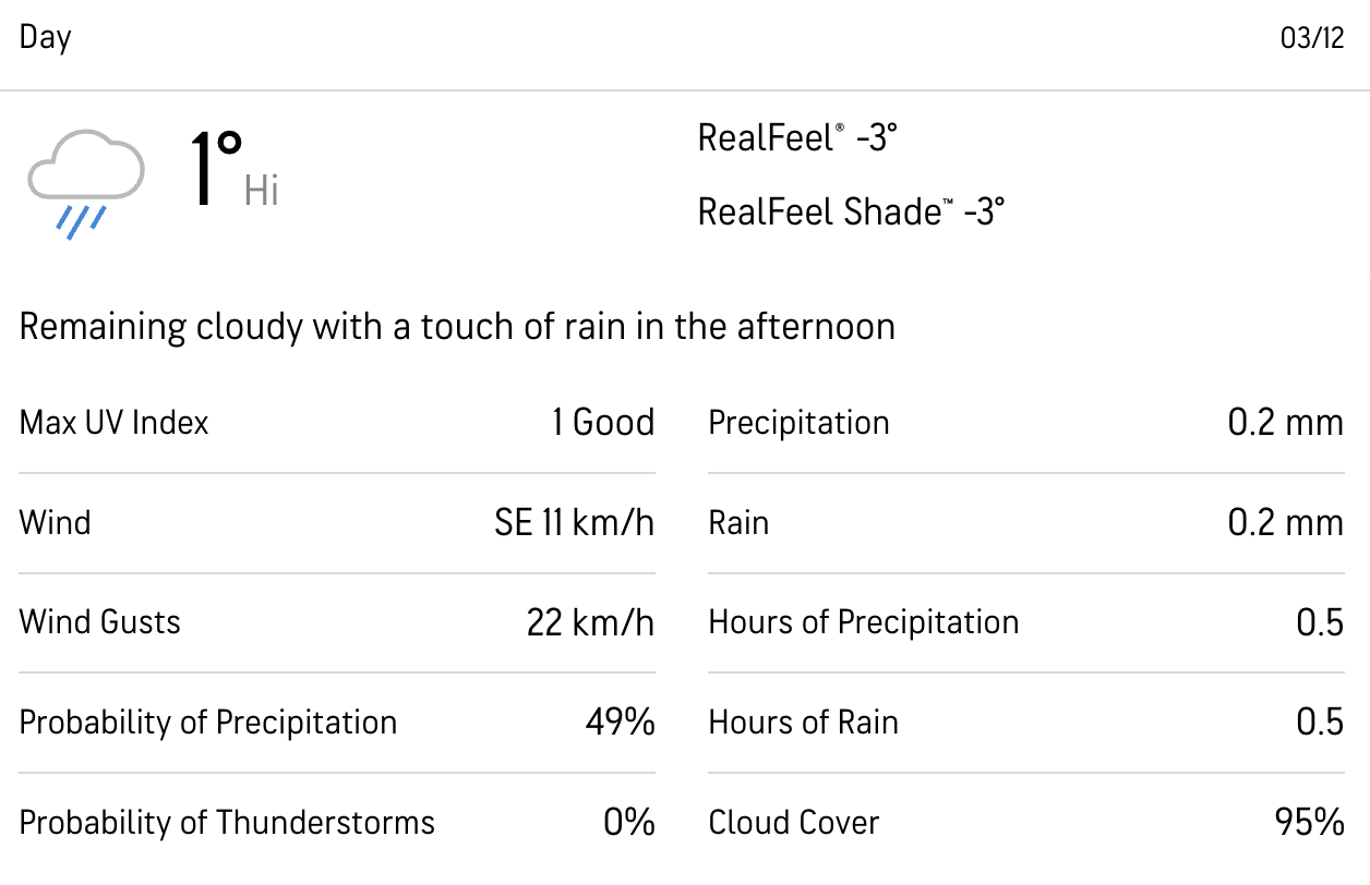
Check out the upcoming weather for Bracebridge here.
Grab breakfast before you go. There's a Tims around the corner from our meet-up point.
Bring a packed lunch, snacks and at least a litre of water for the hike. A hot drink is also a good idea.
Ice spikes will be provided for anyone who has requested them.
Hiking injuries - Wear appropriate footwear, ice spikes and hike within your abilities. If you need extra support, bring hiking poles. This is a tricky hike so you'll need to go slowly and take care not to fall or roll an ankle.
Getting lost - Stay with the group at all times to avoid getting lost. You should also download the map in advance to your phone
Hunting - Hunting is permitted in the area so you should wear an item of bright orange clothing to ensure your visibility. Red is not suitable. Dollarama sells cheap beanies and high-vis jackets.
We like to share some of the indigenous background of the areas we visit because these territories have rich histories that are easy to overlook. Indigenous communities have a connection to and respect for the land that has largely been lost since European settlement. As we strive to form a deeper connection with the land, we have much to learn from these communities. I use the Native Land map to learn more about these areas and find that developing a richer understanding leads to a greater enjoyment of the adventures.
Bracebridge and the surrounding area is on the traditional territory of the Anishnaabe and Missisaugas.