This trip takes us to one of those rare places you won’t find in a guidebook. Tucked just south of Algonquin, the trail is a little-known gem with everything you’d expect from the Canadian Shield: rolling rock outcrops, quiet beaver ponds, and wide ridges that suddenly open up into sweeping views. In autumn, it’s a canvas of red, orange, and gold the kind of colour that makes you stop mid-trail and just look around.
We start with a proper hike - we'll be going 6.5 km on a moderately easy route with enough time to enjoy the scenery before stopping for lunch at one of the most spectacular views you'll find.
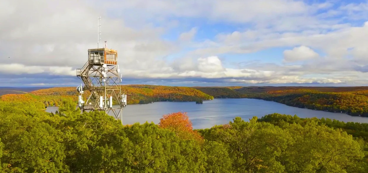
Once the trail is behind us, we’ll make a short drive over to Dorset. The Scenic Lookout Tower rises above the forest canopy, and climbing to the top gives you a view like no other. From up there you get a 360° view of the hills and lakes all dressed in their fall colours. It’s one of Ontario’s most iconic lookouts, but after walking a trail where we had the forest to ourselves, it feels even more special.
This outing combines the best of both worlds: a little-known, quiet hike far from the crowds, and a panoramic view that captures the whole season in a single glance.
Please note that anyone not coming in the shared transportation will need to purchase their own tower access pass here.
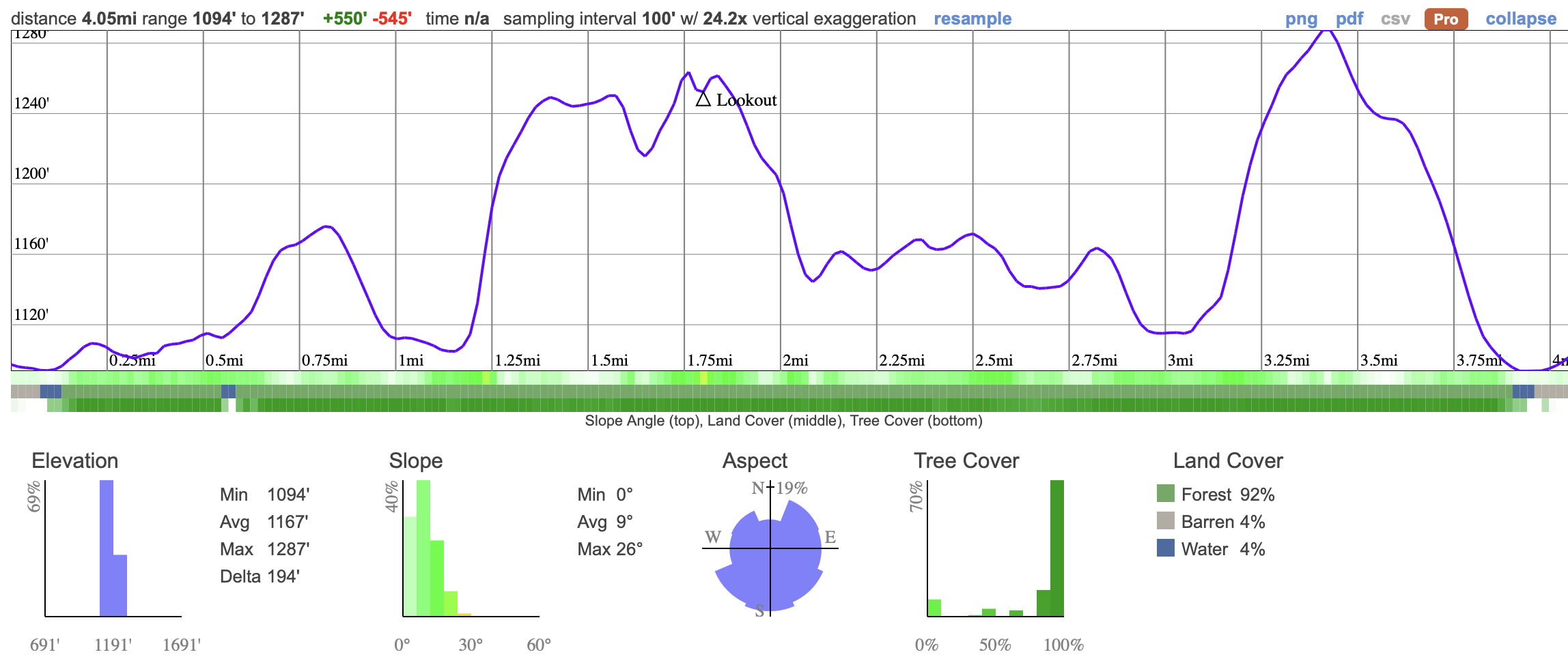
We’ll be hiking a 6.5 km loop at the Frost Centre that links the Fire Tower, Acclimatization, and Lakeshore trails. The route is well marked and considered easy to moderate, with about 120–150 m of elevation gain spread over a few short climbs, mainly on the Fire Tower section. Expect packed dirt paths with some rocky or muddy spots, plus a few fallen trees from winter storms. Along the way we’ll enjoy lakeshore views of St. Nora Lake, winding forest trails, and a higher vantage point near the old fire tower.
06:50 - Meet at the PetroCanada next to Keele Station. There's a Tims around the corner if you want to grab breakfast. THE BUS WILL LEAVE AT 07:00 whether you are here or not so you must be there on time.
07:00 - Bus leaves
10:00 - Meet self drivers and secret trail hike
13:30 - 14:30 - Lookout tower
18:00 - Anticipated arrival back in Toronto
This custom map is georeferenced, meaning it will show you where you are on the map in the right software and lays out the rough path that we’ll be following. It’s opened with the Avenza app which must be downloaded and installed in advance of the adventure.
You should also download the What3words app - this makes it easy to share and find locations in the unlikely event that you get lost.
Packing list
Have any questions? Ask us on the Discord!
Grab breakfast before you go. There's a Tims around the corner from our meet-up point.
Bring a packed lunch, snacks and at least a 2 litres of water for the hike. We also reccomend electolyte drinks for hot days!
Please note that anyone not coming in the shared transportation will need to purchase their own tower access pass here.
You should read all of the instructions in here carefully and make sure you've downloaded and installed the map! It's important that you listen to the guides and follow their instructions at all times.
Hiking injuries: Wear appropriate footwear (ankle high hiking boots) and hike within your abilities. If you need extra support, bring hiking poles.
Getting lost: All hikers must remain with the group at all times. If you do find yourself lost at any point, stay where you are and call for help. If you have a whistle, bring it.
Trail conditions: Trails may be muddy, ensure you're wearing proper footwear with tread and ankle support.
Falling from heights: Watch your step on steep trails and follow safety guidelines on the fire tower.
We like to share some of the indigenous background of the areas we visit because these territories have rich histories that are easy to overlook. Indigenous communities have a connection to and respect for the land that has largely been lost since European settlement. As we strive to form a deeper connection with the land, we have much to learn from these communities. We use the Native Land map to learn more about these areas and find that developing a richer understanding leads to a greater enjoyment of the adventures.
This trip takes us to one of those rare places you won’t find in a guidebook. Tucked just south of Algonquin, the trail is a little-known gem with everything you’d expect from the Canadian Shield: rolling rock outcrops, quiet beaver ponds, and wide ridges that suddenly open up into sweeping views. In autumn, it’s a canvas of red, orange, and gold the kind of colour that makes you stop mid-trail and just look around.
We start with a proper hike - we'll be going 6.5 km on a moderately easy route with enough time to enjoy the scenery before stopping for lunch at one of the most spectacular views you'll find.
Once the trail is behind us, we’ll make a short drive over to Dorset. The Scenic Lookout Tower rises above the forest canopy, and climbing to the top gives you a view like no other. From up there you get a 360° view of the hills and lakes all dressed in their fall colours. It’s one of Ontario’s most iconic lookouts, but after walking a trail where we had the forest to ourselves, it feels even more special.
This outing combines the best of both worlds: a little-known, quiet hike far from the crowds, and a panoramic view that captures the whole season in a single glance.
Please note that anyone not coming in the shared transportation will need to purchase their own tower access pass here.
We’ll be hiking a 6.5 km loop at the Frost Centre that links the Fire Tower, Acclimatization, and Lakeshore trails. The route is well marked and considered easy to moderate, with about 120–150 m of elevation gain spread over a few short climbs, mainly on the Fire Tower section. Expect packed dirt paths with some rocky or muddy spots, plus a few fallen trees from winter storms. Along the way we’ll enjoy lakeshore views of St. Nora Lake, winding forest trails, and a higher vantage point near the old fire tower.
06:50 - Meet at the PetroCanada next to Keele Station. There's a Tims around the corner if you want to grab breakfast. THE BUS WILL LEAVE AT 07:00 whether you are here or not so you must be there on time.
07:00 - Bus leaves
10:00 - Meet self drivers and secret trail hike
13:30 - 14:30 - Lookout tower
18:00 - Anticipated arrival back in Toronto
This custom map is georeferenced, meaning it will show you where you are on the map in the right software and lays out the rough path that we’ll be following. It’s opened with the Avenza app which must be downloaded and installed in advance of the adventure.
You should also download the What3words app - this makes it easy to share and find locations in the unlikely event that you get lost.
Packing list
Have any questions? Ask us on the Discord!
Grab breakfast before you go. There's a Tims around the corner from our meet-up point.
Bring a packed lunch, snacks and at least a 2 litres of water for the hike. We also reccomend electolyte drinks for hot days!
Please note that anyone not coming in the shared transportation will need to purchase their own tower access pass here.
You should read all of the instructions in here carefully and make sure you've downloaded and installed the map! It's important that you listen to the guides and follow their instructions at all times.
Hiking injuries: Wear appropriate footwear (ankle high hiking boots) and hike within your abilities. If you need extra support, bring hiking poles.
Getting lost: All hikers must remain with the group at all times. If you do find yourself lost at any point, stay where you are and call for help. If you have a whistle, bring it.
Trail conditions: Trails may be muddy, ensure you're wearing proper footwear with tread and ankle support.
Falling from heights: Watch your step on steep trails and follow safety guidelines on the fire tower.
We like to share some of the indigenous background of the areas we visit because these territories have rich histories that are easy to overlook. Indigenous communities have a connection to and respect for the land that has largely been lost since European settlement. As we strive to form a deeper connection with the land, we have much to learn from these communities. We use the Native Land map to learn more about these areas and find that developing a richer understanding leads to a greater enjoyment of the adventures.