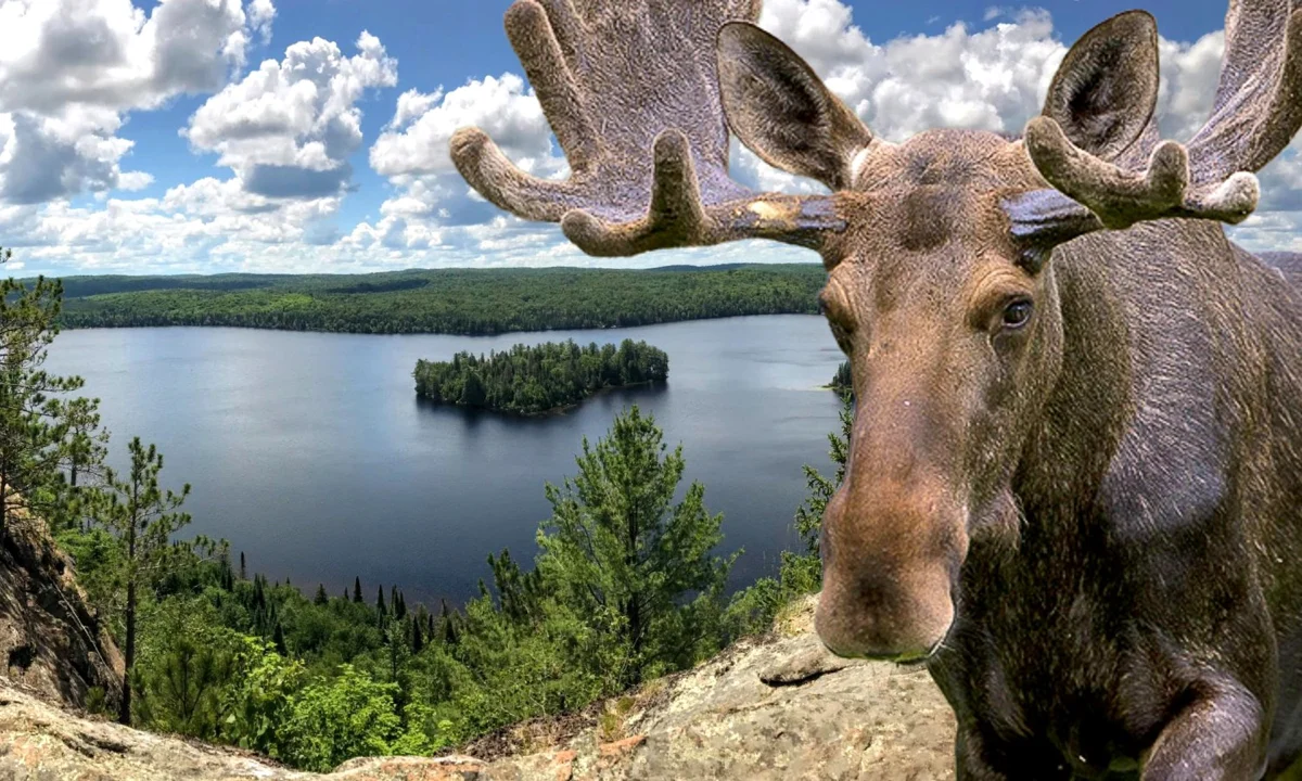
One of the most iconic hikes in Ontario - visiting at this time of year means we get to enjoy it with nobody else around. We'll be driving up to Algonquin and along the famous Highway 60 wildlife corridor keeping our eyes open for moose along the way.
Meeting up with self-drivers at the trail head, we'll tackle this challenging hike and be rewarded with some of the most spectacular views in the park.
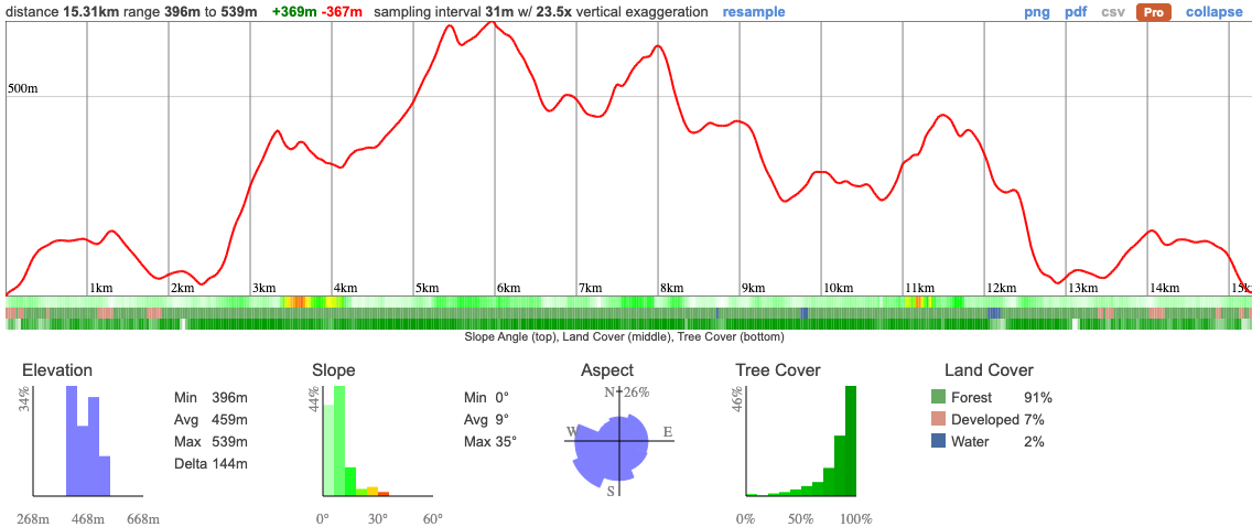
This is a challenging 15km hike. At this time of year the access road will still be closed so we have an additional 2km in each direction to get to the trail-head. The entry to the trail will be flat so we'll smash out this portion of the hike pretty quickly. Getting off the road, the trail becomes considerably more challenging with some steep, rocky ascents. While not excessively long, the ascent is pretty significant so you'll need to be in good shape to successfully make it round!
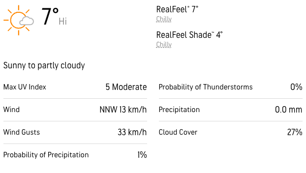
We're expecting just a small amount of snow on the ground but ice spikes and poles (if you find those useful) are strongly recommended.
The hike should take a total of about 6.5 hours with a relatively low average speed of 2.5km/hours. The bits we can take more quickly we will so we can take our time for the more challenging sections.
06:50 - Meet at the PetroCanada next to Keele Station. There's a Tims around the corner if you want to grab breakfast.
07:00 - Head off to Algonquin. We'll make a short stop at an OnRoute.
10:15 - Meet at Trail head. Self-drivers, please ensure you're there on time, we can't wait for latecomers
10:15 - 16:15 - Hike the Centennial Ridges Trail
19:30 - Anticipated arrival back at Keele Station
This custom map is georeferenced, meaning it will show you where you are on the map in the right software and lays out the rough path that we’ll be following. It’s opened with the Avenza app which must be downloaded and installed in advance of the adventure.
You should also download the What3words app - this makes it easy to share and find locations in the unlikely event that you get lost.
General Notes
The snow will have mostly melted so we may have a mixture of slippery muddy conditions. In remote locations like this, it's particularly important that you're dressed appropriately. Please read the following carefully - if you're not dressed safely we will not be able to take you up with us and we all want to avoid that!
That starts with:
Shoes
Hiking boots are essential for this trip. You're going to need good grip and a higher shoe to prevent your feet getting soaked. That's likely to happen anyway so make sure you pack an extra pair of socks.
Trainers and city boots are really not suitable because they won't have sufficient grip and could put you at risk. You won't be able to join us if you're wearing sneakers/blundstones.
Traction
We're not expecting much snow on the trail but if you have ice spikes, you should pack them. We have extras for those who need them.
Clothing packing list
It's also a good idea to bring a whistle in case you need to call for help.
Have any questions? Ask us on the Discord! Members who turn up dressed in a way that puts themselves at risk will not be able to join us.
Have breakfast before you meet us and bring a packed lunch, snacks and at least 1l of water.
We'll be making a short stop en route to the park and may not have enough time to get food so don't rely on this.
We'll have ice spikes available for those who need them.
Self-drivers will need to purchase a daily vehicle permit in advance for the Algonquin Hwy 60 Corridor here. We won't be stopping in at the visitor centre so make sure you get this asap and pre-register.
Cars carrying a Canoo member (somebody who recently got their citizenship) may not need to pay but will still need to register.
You should read all of the instructions in here carefully and make sure you've downloaded and installed the map! It's important that you listen to the guides and follow their instructions at all times.
Hiking injuries: There are a lot of rocks on the trail and it's easy to roll an ankle. Be careful when walking and bring poles if helpful.
Getting lost: All hikers must remain with the group at all times. If you do find yourself lost at any point, stay where you are and call for help. If you have a whistle, bring it.
Trail conditions: Trails may be icy, ensure you're wearing ice spikes if recommended.
Falling from heights: There are some steep cliffs on this trail, don't get too close to any.
Wildlife: Bears and moose are not uncommon around this area. If you come across a larger animal, back away and alert the group.
Algonquin Park has a rich indigenous history that predates the establishment of the park itself. The park is situated on the traditional territories of several Algonquian-speaking First Nations, including the Algonquin, Anishinaabe, and Huron-Wendat peoples.
For thousands of years, these indigenous communities relied on the land and its resources for sustenance, trade, and cultural practices. They engaged in hunting, fishing, gathering, and agriculture, establishing seasonal camps and villages throughout the region. The lakes, rivers, and forests provided them with a diverse range of food, such as fish, game, berries, and medicinal plants.
The Algonquin people, in particular, have a deep connection to the land that encompasses Algonquin Park. They refer to themselves as Anishinaabe, which translates to "the people" in their language. Their traditional territories extended across a vast area in present-day Ontario and Quebec.
Algonquin Park, as we know it today, was established in 1893 as the first provincial park in Canada. The creation of the park disrupted the traditional way of life for indigenous communities in the area. Many were displaced from their ancestral lands, and their access to resources and sacred sites within the park was restricted.
Despite these challenges, indigenous peoples have maintained their cultural connections to the region. They continue to assert their rights and engage in land stewardship initiatives, collaborating with the government and other stakeholders to protect and preserve their cultural heritage within Algonquin Park.
One of the most iconic hikes in Ontario - visiting at this time of year means we get to enjoy it with nobody else around. We'll be driving up to Algonquin and along the famous Highway 60 wildlife corridor keeping our eyes open for moose along the way.
Meeting up with self-drivers at the trail head, we'll tackle this challenging hike and be rewarded with some of the most spectacular views in the park.
This is a challenging 15km hike. At this time of year the access road will still be closed so we have an additional 2km in each direction to get to the trail-head. The entry to the trail will be flat so we'll smash out this portion of the hike pretty quickly. Getting off the road, the trail becomes considerably more challenging with some steep, rocky ascents. While not excessively long, the ascent is pretty significant so you'll need to be in good shape to successfully make it round!
We're expecting just a small amount of snow on the ground but ice spikes and poles (if you find those useful) are strongly recommended.
The hike should take a total of about 6.5 hours with a relatively low average speed of 2.5km/hours. The bits we can take more quickly we will so we can take our time for the more challenging sections.
06:50 - Meet at the PetroCanada next to Keele Station. There's a Tims around the corner if you want to grab breakfast.
07:00 - Head off to Algonquin. We'll make a short stop at an OnRoute.
10:15 - Meet at Trail head. Self-drivers, please ensure you're there on time, we can't wait for latecomers
10:15 - 16:15 - Hike the Centennial Ridges Trail
19:30 - Anticipated arrival back at Keele Station
This custom map is georeferenced, meaning it will show you where you are on the map in the right software and lays out the rough path that we’ll be following. It’s opened with the Avenza app which must be downloaded and installed in advance of the adventure.
You should also download the What3words app - this makes it easy to share and find locations in the unlikely event that you get lost.
General Notes
The snow will have mostly melted so we may have a mixture of slippery muddy conditions. In remote locations like this, it's particularly important that you're dressed appropriately. Please read the following carefully - if you're not dressed safely we will not be able to take you up with us and we all want to avoid that!
That starts with:
Shoes
Hiking boots are essential for this trip. You're going to need good grip and a higher shoe to prevent your feet getting soaked. That's likely to happen anyway so make sure you pack an extra pair of socks.
Trainers and city boots are really not suitable because they won't have sufficient grip and could put you at risk. You won't be able to join us if you're wearing sneakers/blundstones.
Traction
We're not expecting much snow on the trail but if you have ice spikes, you should pack them. We have extras for those who need them.
Clothing packing list
It's also a good idea to bring a whistle in case you need to call for help.
Have any questions? Ask us on the Discord! Members who turn up dressed in a way that puts themselves at risk will not be able to join us.
Have breakfast before you meet us and bring a packed lunch, snacks and at least 1l of water.
We'll be making a short stop en route to the park and may not have enough time to get food so don't rely on this.
We'll have ice spikes available for those who need them.
Self-drivers will need to purchase a daily vehicle permit in advance for the Algonquin Hwy 60 Corridor here. We won't be stopping in at the visitor centre so make sure you get this asap and pre-register.
Cars carrying a Canoo member (somebody who recently got their citizenship) may not need to pay but will still need to register.
You should read all of the instructions in here carefully and make sure you've downloaded and installed the map! It's important that you listen to the guides and follow their instructions at all times.
Hiking injuries: There are a lot of rocks on the trail and it's easy to roll an ankle. Be careful when walking and bring poles if helpful.
Getting lost: All hikers must remain with the group at all times. If you do find yourself lost at any point, stay where you are and call for help. If you have a whistle, bring it.
Trail conditions: Trails may be icy, ensure you're wearing ice spikes if recommended.
Falling from heights: There are some steep cliffs on this trail, don't get too close to any.
Wildlife: Bears and moose are not uncommon around this area. If you come across a larger animal, back away and alert the group.
Algonquin Park has a rich indigenous history that predates the establishment of the park itself. The park is situated on the traditional territories of several Algonquian-speaking First Nations, including the Algonquin, Anishinaabe, and Huron-Wendat peoples.
For thousands of years, these indigenous communities relied on the land and its resources for sustenance, trade, and cultural practices. They engaged in hunting, fishing, gathering, and agriculture, establishing seasonal camps and villages throughout the region. The lakes, rivers, and forests provided them with a diverse range of food, such as fish, game, berries, and medicinal plants.
The Algonquin people, in particular, have a deep connection to the land that encompasses Algonquin Park. They refer to themselves as Anishinaabe, which translates to "the people" in their language. Their traditional territories extended across a vast area in present-day Ontario and Quebec.
Algonquin Park, as we know it today, was established in 1893 as the first provincial park in Canada. The creation of the park disrupted the traditional way of life for indigenous communities in the area. Many were displaced from their ancestral lands, and their access to resources and sacred sites within the park was restricted.
Despite these challenges, indigenous peoples have maintained their cultural connections to the region. They continue to assert their rights and engage in land stewardship initiatives, collaborating with the government and other stakeholders to protect and preserve their cultural heritage within Algonquin Park.