A two for one trip where we'll be visiting one of the most interesting but unheard of hikes that's close to Toronto followed by a trip to the famous town of Creemore.
We'll begin with an 8km hike at a conservation area that takes us along a forest and meadows before leading through a rock face that will require a bit of a squeeze to emerge on the other side of a cave. This is a pretty easy hike with one steep section that leads us to an incredible view over the surrounding area.
Once we're done with our hike, we'll drive to nearby Creemore, where we'll visit the famous brewery, wander around, pop into cute shops, and soak in the small-town vibes.
Hike Length: 8km
Terrain: A generally easy hike with a couple of steeper sections. We'll be on a mix of forested trails, farm land, the edge of marsh land and walking through caves.
Estimated time to complete: 3 hours with breaks and exploration time.

08:50: Those taking the van meet at the Petrocanada next to Keele Subway Station. Driving to the shuttle location? There's free parking here.
09:00: Shuttle leaves from PetroCanada at Keele Station. Please note that we leave dead on 9am and can't wait for latecomers.
10:30: Meet self-drivers at trail head. Navigate to Nottawasaga Bluffs Conservation Area
10:30 - 13:30: Hike, stopping for lunch en route
13:30 - Drive to Creemore to explore the town
14:30 - Leave Creemore
16:30 - Anticipated return to Keele Station
This custom map is georeferenced, meaning it will show you where you are on the map in the right software and lays out the rough path that we’ll be following. It’s opened with the Avenza app which must be downloaded and installed in advance of the adventure.
You should also download the What3words app - this makes it easy to share and find locations in the unlikely event that you get lost.
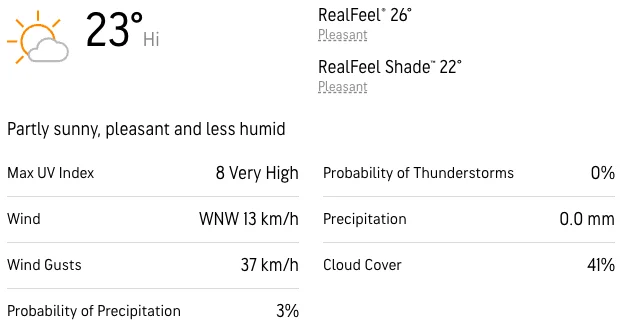
Heat Exhaustion/Sun Exposure - It's a very hot day with heat exhaustion and sunburn a real possibility. Follow these steps to protect yourself:
Hiking injuries - Wear appropriate footwear and hike within your abilities. If you need extra support, bring hiking poles. Any injuries? Let us know in advance of the hike.
Ticks - Black legged ticks are in the area. You should wear pants rather than shorts to prevent them latching on and lighter colours make it easier to spot them and keep you more cool. There's no need to worry about ticks if we take a few precautions and we'll talk about doing a tick check after the hike just to confirm we haven't picked any up. You can learn more here.
We like to share some of the indigenous background of the areas we visit because these territories have rich histories that are easy to overlook. Indigenous communities have a connection to and respect for the land that has largely been lost since European settlement. As we strive to form a deeper connection with the land, we have much to learn from these communities. I use the Native Land map to learn more about these areas and find that developing a richer understanding leads to a greater enjoyment of the adventures.
Nations who still have connections to the area are the Missisaugas of the Credit First Nation the Petun, the Anishnabe and Haudenosaunee.
A two for one trip where we'll be visiting one of the most interesting but unheard of hikes that's close to Toronto followed by a trip to the famous town of Creemore.
We'll begin with an 8km hike at a conservation area that takes us along a forest and meadows before leading through a rock face that will require a bit of a squeeze to emerge on the other side of a cave. This is a pretty easy hike with one steep section that leads us to an incredible view over the surrounding area.
Once we're done with our hike, we'll drive to nearby Creemore, where we'll visit the famous brewery, wander around, pop into cute shops, and soak in the small-town vibes.
Hike Length: 8km
Terrain: A generally easy hike with a couple of steeper sections. We'll be on a mix of forested trails, farm land, the edge of marsh land and walking through caves.
Estimated time to complete: 3 hours with breaks and exploration time.
08:50: Those taking the van meet at the Petrocanada next to Keele Subway Station. Driving to the shuttle location? There's free parking here.
09:00: Shuttle leaves from PetroCanada at Keele Station. Please note that we leave dead on 9am and can't wait for latecomers.
10:30: Meet self-drivers at trail head. Navigate to Nottawasaga Bluffs Conservation Area
10:30 - 13:30: Hike, stopping for lunch en route
13:30 - Drive to Creemore to explore the town
14:30 - Leave Creemore
16:30 - Anticipated return to Keele Station
This custom map is georeferenced, meaning it will show you where you are on the map in the right software and lays out the rough path that we’ll be following. It’s opened with the Avenza app which must be downloaded and installed in advance of the adventure.
You should also download the What3words app - this makes it easy to share and find locations in the unlikely event that you get lost.
Heat Exhaustion/Sun Exposure - It's a very hot day with heat exhaustion and sunburn a real possibility. Follow these steps to protect yourself:
Hiking injuries - Wear appropriate footwear and hike within your abilities. If you need extra support, bring hiking poles. Any injuries? Let us know in advance of the hike.
Ticks - Black legged ticks are in the area. You should wear pants rather than shorts to prevent them latching on and lighter colours make it easier to spot them and keep you more cool. There's no need to worry about ticks if we take a few precautions and we'll talk about doing a tick check after the hike just to confirm we haven't picked any up. You can learn more here.
We like to share some of the indigenous background of the areas we visit because these territories have rich histories that are easy to overlook. Indigenous communities have a connection to and respect for the land that has largely been lost since European settlement. As we strive to form a deeper connection with the land, we have much to learn from these communities. I use the Native Land map to learn more about these areas and find that developing a richer understanding leads to a greater enjoyment of the adventures.
Nations who still have connections to the area are the Missisaugas of the Credit First Nation the Petun, the Anishnabe and Haudenosaunee.
