Those of you who took part in our previous foraging events will know outdoor educator and naturalist Bryan Dowkes who is co-leading his first trip with us this weekend!
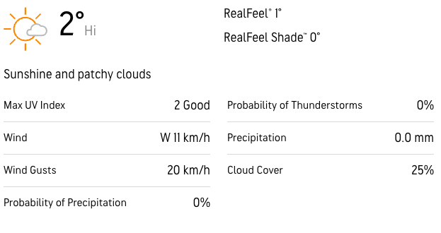
This adventure is a bit of a rarity, a Provincial Park on the outskirts of the city. It's got beautiful hiking trails that will take us through forest, alongside rivers and a massive ravine. This is an easy hike that's suitable for hikers of all levels and for new members, a great opportunity to meet other people in the group!
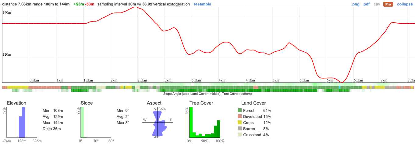
The route is just under 8km with very little elevation.
Hike Length: 7.7km
Terrain: We'll be on well trodden trails through the forest. It's an easy hike that's suitable for everyone.
Estimated time to complete: 4 hours with breaks and exploration time.
09:50: Those taking the van meet at the Petrocanada next to Keele Subway Station. Driving to the shuttle location? There's free parking here.
10:00: Shuttle leaves. Please note that out of respect for each other, we leave dead on time and can not wait for latecomers.
10:30: Meet self-drivers at car park (free parking)
10:45 - 14:30: Hike, stopping for lunch en route
15:30: Anticipated return to Keele subway station
This custom map is georeferenced, meaning it will show you where you are on the map in the right software and lays out the rough path that we’ll be following. It’s opened with the Avenza app which must be downloaded and installed in advance of the adventure.
You should also download the What3words app - this makes it easy to share and find locations in the unlikely event that you get lost.
Remember to pack a lunch, some snacks and at least 1l of water.
Self drivers will need to register an $18 daily vehicle permit here.
Hiking injuries - Wear appropriate footwear and hike within your abilities. If you need extra support, bring hiking poles.
We like to share some of the indigenous background of the areas we visit because these territories have rich histories that are easy to overlook. Indigenous communities have a connection to and respect for the land that has largely been lost since European settlement. As we strive to form a deeper connection with the land, we have much to learn from these communities. I use the Native Land map to learn more about these areas and find that developing a richer understanding leads to a greater enjoyment of the adventures.
The area around Bronte creek is part of the traditional territories of several Indigenous Peoples, including the Missisaugas of the Credit First Nation, the Anishnabe, Haudenosaunee, and the Huron Wendat.. These lands have been inhabited and cared for by Indigenous communities for thousands of years, long before the arrival of European settlers. The relationships to the land, waterways, and natural resources were, and continue to be, of vital importance to these communities. Traditional activities like hunting, fishing, trapping, and gathering have taken place here, and these landscapes are imbued with cultural and spiritual significance.
The colonization of these areas led to the displacement, dispossession, and disenfranchisement of Indigenous Peoples, a legacy that is still felt today. Treaties were often signed under coercive conditions, and land was frequently appropriated without the free, prior, and informed consent of the Indigenous communities concerned.
We acknowledge the traditional Indigenous caretakers of the land and are making ongoing attempts to engage with this history in a manner that respects and honours their ongoing relationship with the land.
Those of you who took part in our previous foraging events will know outdoor educator and naturalist Bryan Dowkes who is co-leading his first trip with us this weekend!
This adventure is a bit of a rarity, a Provincial Park on the outskirts of the city. It's got beautiful hiking trails that will take us through forest, alongside rivers and a massive ravine. This is an easy hike that's suitable for hikers of all levels and for new members, a great opportunity to meet other people in the group!
The route is just under 8km with very little elevation.
Hike Length: 7.7km
Terrain: We'll be on well trodden trails through the forest. It's an easy hike that's suitable for everyone.
Estimated time to complete: 4 hours with breaks and exploration time.
09:50: Those taking the van meet at the Petrocanada next to Keele Subway Station. Driving to the shuttle location? There's free parking here.
10:00: Shuttle leaves. Please note that out of respect for each other, we leave dead on time and can not wait for latecomers.
10:30: Meet self-drivers at car park (free parking)
10:45 - 14:30: Hike, stopping for lunch en route
15:30: Anticipated return to Keele subway station
This custom map is georeferenced, meaning it will show you where you are on the map in the right software and lays out the rough path that we’ll be following. It’s opened with the Avenza app which must be downloaded and installed in advance of the adventure.
You should also download the What3words app - this makes it easy to share and find locations in the unlikely event that you get lost.
Remember to pack a lunch, some snacks and at least 1l of water.
Self drivers will need to register an $18 daily vehicle permit here.
Hiking injuries - Wear appropriate footwear and hike within your abilities. If you need extra support, bring hiking poles.
We like to share some of the indigenous background of the areas we visit because these territories have rich histories that are easy to overlook. Indigenous communities have a connection to and respect for the land that has largely been lost since European settlement. As we strive to form a deeper connection with the land, we have much to learn from these communities. I use the Native Land map to learn more about these areas and find that developing a richer understanding leads to a greater enjoyment of the adventures.
The area around Bronte creek is part of the traditional territories of several Indigenous Peoples, including the Missisaugas of the Credit First Nation, the Anishnabe, Haudenosaunee, and the Huron Wendat.. These lands have been inhabited and cared for by Indigenous communities for thousands of years, long before the arrival of European settlers. The relationships to the land, waterways, and natural resources were, and continue to be, of vital importance to these communities. Traditional activities like hunting, fishing, trapping, and gathering have taken place here, and these landscapes are imbued with cultural and spiritual significance.
The colonization of these areas led to the displacement, dispossession, and disenfranchisement of Indigenous Peoples, a legacy that is still felt today. Treaties were often signed under coercive conditions, and land was frequently appropriated without the free, prior, and informed consent of the Indigenous communities concerned.
We acknowledge the traditional Indigenous caretakers of the land and are making ongoing attempts to engage with this history in a manner that respects and honours their ongoing relationship with the land.