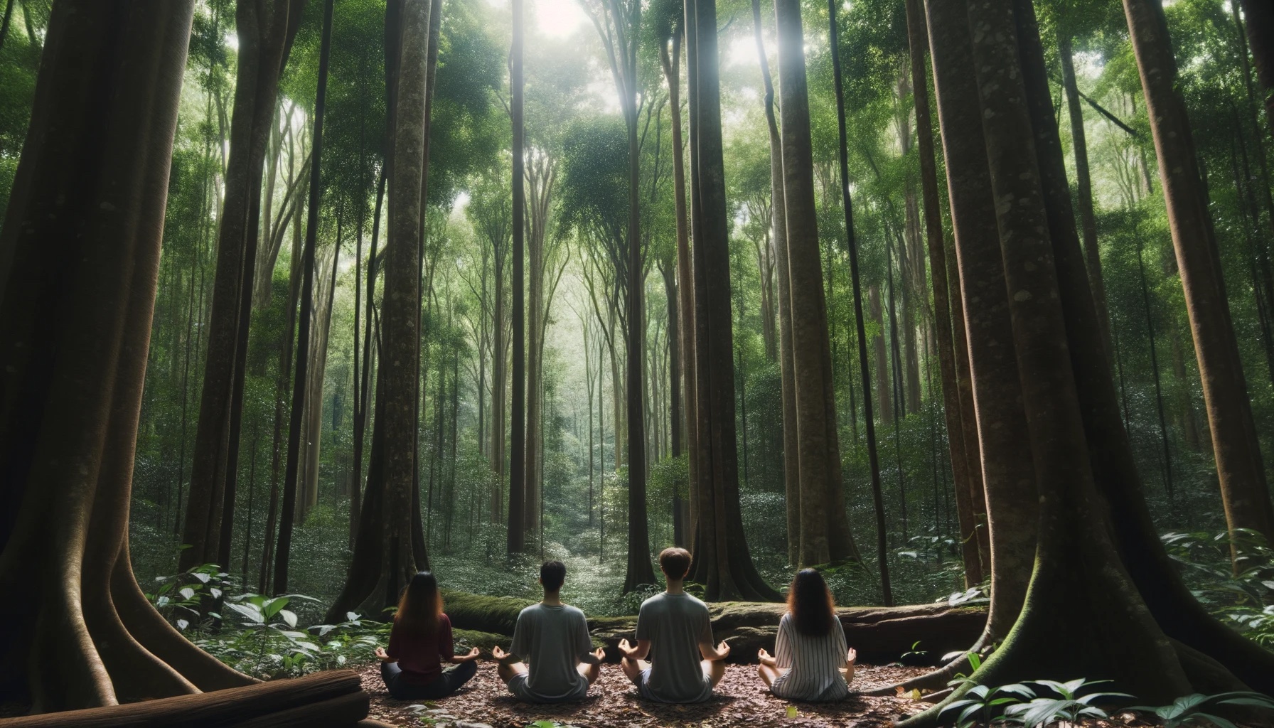
Escape the hustle and bustle of daily life and connect with nature and yourself on this mindful hike.
Be fully present with your surroundings, leave stress behind, and rediscover the calm within. As we set out on this journey, we'll be guided by fellow member Zeeshan who will facilitate mindfulness practices to help you tune into the sights, sounds, and sensations of the natural world, including:
Nature Observation: Pause and observe the intricate details of nature, from the smallest insects to the grandeur of ancient trees.
Silent Contemplation: At various points along the trail, enjoy moments of silence to reflect and connect with your inner self.
Sound Meditation: Tune in to the sounds of the forest, from birdsong to rustling leaves, and use these natural rhythms as anchors for your mindfulness practice.The first half of this hike will focus on personal reflection, while the second half will more closely resemble one of our typical hikes, giving us an opportunity to share our experience with others.
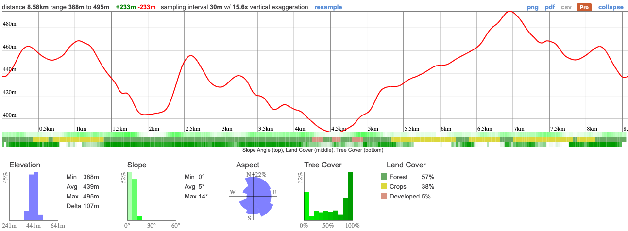
We'll be going to one of the most rarely visited parts of the Bruce Trail, giving you all the best aspects of a well maintained trail, without the hordes of people you find on other stretches. It's a relatively short hike but one with plenty of great scenery and varied terrain to keep things interesting.

The 900km Bruce Trail is probably the most famous hiking trail in Southern Ontario. A lot of it is pretty similar so we tend to avoid it but Boyne Valley is worth the exception. There are very few people on trail, it’s a gorgeous route and super varied. We’ll walk through managed forests, wide open fields, across lookouts and in and out of a valley. This will be a totally new way of looking at a hike that you may even have done before.

This is a pretty easy hike and only 9km so, as long as you have a basic level of fitness you’ll have no problem taking it on.
Hike Length: 8.6km
Terrain: We'll be on well trodden trails through the forest and farms. There's a decent amount of elevation but nothing that's too steep
Estimated time to complete: 5 hours with breaks and exploration time.
08:50: Those taking the van meet at the Petrocanada next to Keele Subway Station. Driving to the shuttle location? There's free parking here.
09:00: Shuttle leaves. Please note that out of respect for each other, we leave dead on time and can not wait for latecomers.
10:00: Meet self-drivers at car park (free parking)
10:00 - 15:00: Hike, stopping for lunch en route
16:30: Anticipated return to Keele subway station
This custom map is georeferenced, meaning it will show you where you are on the map in the right software and lays out the rough path that we’ll be following. It’s opened with the Avenza app which must be downloaded and installed in advance of the adventure.
You should also download the What3words app - this makes it easy to share and find locations in the unlikely event that you get lost.
Remember to pack a lunch, some snacks and at least 1l of water.
Hiking injuries - Wear appropriate footwear and hike within your abilities. If you need extra support, bring hiking poles.
We like to share some of the indigenous background of the areas we visit because these territories have rich histories that are easy to overlook. Indigenous communities have a connection to and respect for the land that has largely been lost since European settlement. As we strive to form a deeper connection with the land, we have much to learn from these communities. I use the Native Land map to learn more about these areas and find that developing a richer understanding leads to a greater enjoyment of the adventures.
The areas around Boyne Valley is part of the traditional territories of several Indigenous Peoples, including the Petun, the Missisaugas of the Credit First Nation, the Anishnabe, Haudenosaunee, and the Huron Wendat.. These lands have been inhabited and cared for by Indigenous communities for thousands of years, long before the arrival of European settlers. The relationships to the land, waterways, and natural resources were, and continue to be, of vital importance to these communities. Traditional activities like hunting, fishing, trapping, and gathering have taken place here, and these landscapes are imbued with cultural and spiritual significance.
The colonization of these areas led to the displacement, dispossession, and disenfranchisement of Indigenous Peoples, a legacy that is still felt today. Treaties were often signed under coercive conditions, and land was frequently appropriated without the free, prior, and informed consent of the Indigenous communities concerned.
We acknowledge the traditional Indigenous caretakers of the land and are making ongoing attempts to engage with this history in a manner that respects and honours their ongoing relationship with the land.
Escape the hustle and bustle of daily life and connect with nature and yourself on this mindful hike.
Be fully present with your surroundings, leave stress behind, and rediscover the calm within. As we set out on this journey, we'll be guided by fellow member Zeeshan who will facilitate mindfulness practices to help you tune into the sights, sounds, and sensations of the natural world, including:
Nature Observation: Pause and observe the intricate details of nature, from the smallest insects to the grandeur of ancient trees.
Silent Contemplation: At various points along the trail, enjoy moments of silence to reflect and connect with your inner self.
Sound Meditation: Tune in to the sounds of the forest, from birdsong to rustling leaves, and use these natural rhythms as anchors for your mindfulness practice.The first half of this hike will focus on personal reflection, while the second half will more closely resemble one of our typical hikes, giving us an opportunity to share our experience with others.
We'll be going to one of the most rarely visited parts of the Bruce Trail, giving you all the best aspects of a well maintained trail, without the hordes of people you find on other stretches. It's a relatively short hike but one with plenty of great scenery and varied terrain to keep things interesting.
The 900km Bruce Trail is probably the most famous hiking trail in Southern Ontario. A lot of it is pretty similar so we tend to avoid it but Boyne Valley is worth the exception. There are very few people on trail, it’s a gorgeous route and super varied. We’ll walk through managed forests, wide open fields, across lookouts and in and out of a valley. This will be a totally new way of looking at a hike that you may even have done before.
This is a pretty easy hike and only 9km so, as long as you have a basic level of fitness you’ll have no problem taking it on.
Hike Length: 8.6km
Terrain: We'll be on well trodden trails through the forest and farms. There's a decent amount of elevation but nothing that's too steep
Estimated time to complete: 5 hours with breaks and exploration time.
08:50: Those taking the van meet at the Petrocanada next to Keele Subway Station. Driving to the shuttle location? There's free parking here.
09:00: Shuttle leaves. Please note that out of respect for each other, we leave dead on time and can not wait for latecomers.
10:00: Meet self-drivers at car park (free parking)
10:00 - 15:00: Hike, stopping for lunch en route
16:30: Anticipated return to Keele subway station
This custom map is georeferenced, meaning it will show you where you are on the map in the right software and lays out the rough path that we’ll be following. It’s opened with the Avenza app which must be downloaded and installed in advance of the adventure.
You should also download the What3words app - this makes it easy to share and find locations in the unlikely event that you get lost.
Keep an eye on the weather here. It's looking pretty nice but a bit chilly so make sure you bring some warm layers (but nothing too bulky!)
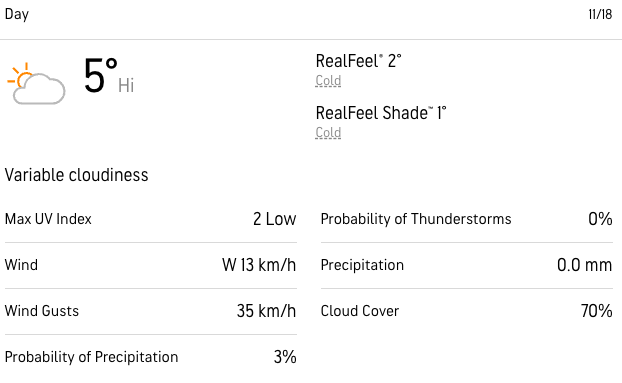
Keep an eye on the weather here. It's looking pretty nice but a bit chilly so make sure you bring some warm layers (but nothing too bulky!)
Remember to pack a lunch, some snacks and at least 1l of water.
Hiking injuries - Wear appropriate footwear and hike within your abilities. If you need extra support, bring hiking poles.
We like to share some of the indigenous background of the areas we visit because these territories have rich histories that are easy to overlook. Indigenous communities have a connection to and respect for the land that has largely been lost since European settlement. As we strive to form a deeper connection with the land, we have much to learn from these communities. I use the Native Land map to learn more about these areas and find that developing a richer understanding leads to a greater enjoyment of the adventures.
The areas around Boyne Valley is part of the traditional territories of several Indigenous Peoples, including the Petun, the Missisaugas of the Credit First Nation, the Anishnabe, Haudenosaunee, and the Huron Wendat.. These lands have been inhabited and cared for by Indigenous communities for thousands of years, long before the arrival of European settlers. The relationships to the land, waterways, and natural resources were, and continue to be, of vital importance to these communities. Traditional activities like hunting, fishing, trapping, and gathering have taken place here, and these landscapes are imbued with cultural and spiritual significance.
The colonization of these areas led to the displacement, dispossession, and disenfranchisement of Indigenous Peoples, a legacy that is still felt today. Treaties were often signed under coercive conditions, and land was frequently appropriated without the free, prior, and informed consent of the Indigenous communities concerned.
We acknowledge the traditional Indigenous caretakers of the land and are making ongoing attempts to engage with this history in a manner that respects and honours their ongoing relationship with the land.