YESSSS we're doing this!
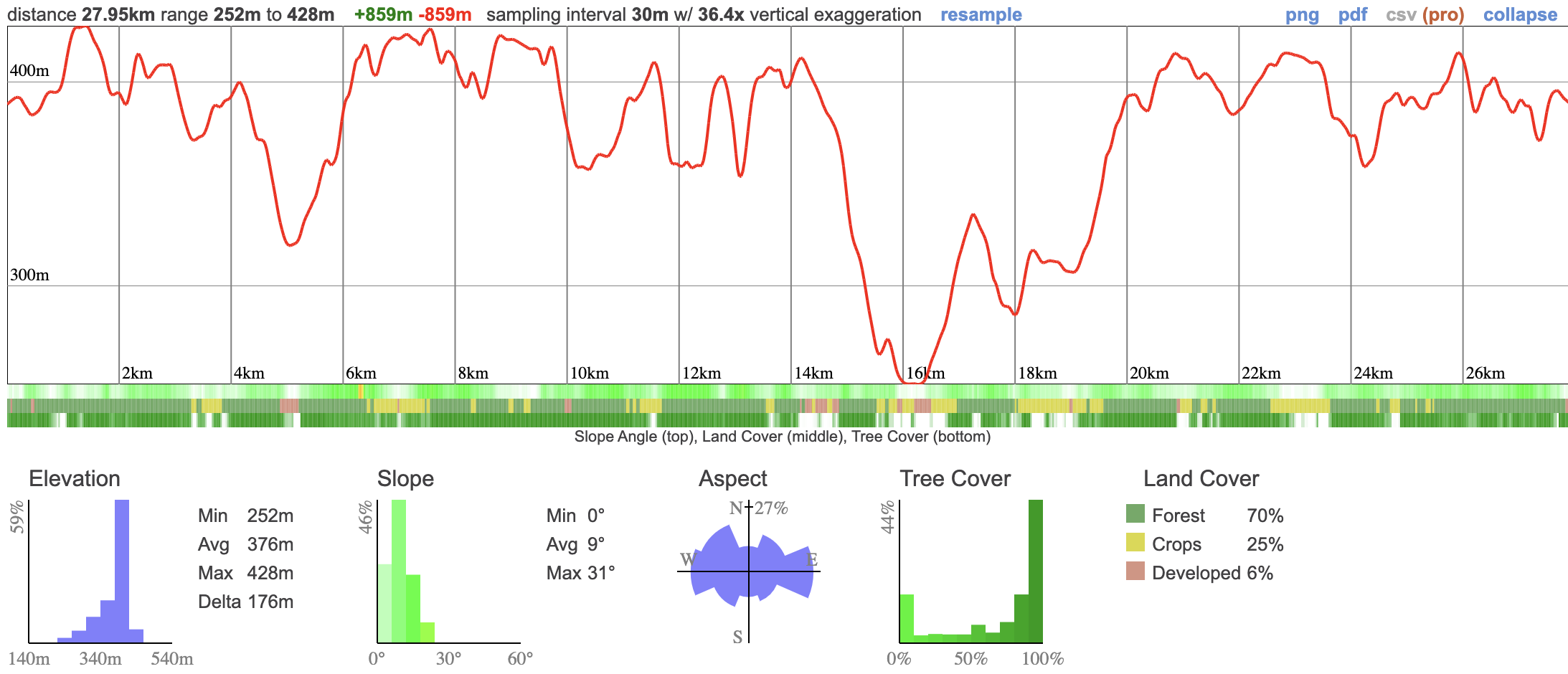
This adventure is a massive 28km hike that takes in nearly a kilometer of elevation along the Bruce Trail. We'll pass the stunning 30m high Eugenia Falls before embarking on a loop through the Niagara escarpment - across farmland, woods, Hoggs Falls and up and down some more technical sections. While the distance is pretty intimidating, it's a safe spot to test ourselves being close to civilization but quiet enough that we shouldn't see many other people.
The longest hike we've done this year! There should be some really beautiful spots along the route which is mostly forest and farm land. It looks like there'll be some pretty steep sections but I'm not anticipating anything excessively technical.
I suspect we'll average about 4.5km/hr but I've given us plenty of time to take lunch and other eventualities into account.
06:20 - Shuttle meet-up time.
06:30 - Shuttle leaves Petrocanada by Keele Subway Station. We leave dead on time - don't be late!
08:00 - Meet at trailhead and begin hike. Self-drivers - please ensure you're here on time.
17:30 - Anticipated end of hike
19:30 - Anticipated return to Toronto
This custom map is georeferenced, meaning it will show you where you are on the map in the right software and lays out the rough path that we’ll be following. It’s opened with the Avenza app which must be downloaded and installed in advance of the adventure.
You should also download the What3words app - this makes it easy to share and find locations in the unlikely event that you get lost.
We like to share some of the indigenous background of the areas we visit because these territories have rich histories that are easy to overlook. Indigenous communities have a connection to and respect for the land that has largely been lost since European settlement. As we strive to form a deeper connection with the land, we have much to learn from these communities. I use the Native Land map to learn more about these areas and find that developing a richer understanding leads to a greater enjoyment of the adventures.
Nations who still have connections to the area are the Missisaugas of the Credit First Nation the Petun, the Anishnabe and Haudenosaunee.
YESSSS we're doing this!
This adventure is a massive 28km hike that takes in nearly a kilometer of elevation along the Bruce Trail. We'll pass the stunning 30m high Eugenia Falls before embarking on a loop through the Niagara escarpment - across farmland, woods, Hoggs Falls and up and down some more technical sections. While the distance is pretty intimidating, it's a safe spot to test ourselves being close to civilization but quiet enough that we shouldn't see many other people.
The longest hike we've done this year! There should be some really beautiful spots along the route which is mostly forest and farm land. It looks like there'll be some pretty steep sections but I'm not anticipating anything excessively technical.
I suspect we'll average about 4.5km/hr but I've given us plenty of time to take lunch and other eventualities into account.
06:20 - Shuttle meet-up time.
06:30 - Shuttle leaves Petrocanada by Keele Subway Station. We leave dead on time - don't be late!
08:00 - Meet at trailhead and begin hike. Self-drivers - please ensure you're here on time.
17:30 - Anticipated end of hike
19:30 - Anticipated return to Toronto
This custom map is georeferenced, meaning it will show you where you are on the map in the right software and lays out the rough path that we’ll be following. It’s opened with the Avenza app which must be downloaded and installed in advance of the adventure.
You should also download the What3words app - this makes it easy to share and find locations in the unlikely event that you get lost.
We like to share some of the indigenous background of the areas we visit because these territories have rich histories that are easy to overlook. Indigenous communities have a connection to and respect for the land that has largely been lost since European settlement. As we strive to form a deeper connection with the land, we have much to learn from these communities. I use the Native Land map to learn more about these areas and find that developing a richer understanding leads to a greater enjoyment of the adventures.
Nations who still have connections to the area are the Missisaugas of the Credit First Nation the Petun, the Anishnabe and Haudenosaunee.
