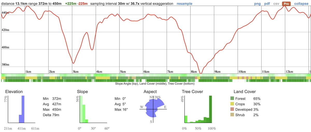
We're hiking a particularly beautiful section of the Bruce Trail that takes you into the Blue Mountains. This 13km hike takes us through a mixture of meadows and forest with some incredible views over Georgian Bay.
The hike is suitable for all members who are in good shape - it's not too long but has about 300m of elevation meaning there'll be some steeper sections. It's a great time to visit and a chance to catch the last of the fall colours.
Hike Length: 13km
Terrain: A mixture of flat wooded areas, open fields, forest and some steep climbs.
Estimated time to complete: 6 hours with breaks and exploration time.
07:20: Those taking the van meet at the Petro Canada next to Keele Subway Station.
07:30: Shuttle leaves. Please note that out of respect for each other, we leave dead on time and can not wait for latecomers.
07:55: Pick up Tanishka in Brampton.
09:45: Meet self drivers at the trail head (116-102 Maple Ln, Ravenna, ON N0H 2E0)
09:45 - 16:00: Hike, stopping for lunch en route
18:30: Anticipated return to Keele subway station
This custom map is georeferenced, meaning it will show you where you are on the map in the right software and lays out the rough path that we’ll be following. It’s opened with the Avenza app which must be downloaded and installed in advance of the adventure.
You should also download the What3words app - this makes it easy to share and find locations in the unlikely event that you get lost.
Remember to pack a lunch, some snacks and at least 1l of water.
Hiking injuries - Wear appropriate footwear and hike within your abilities. If you need extra support, bring hiking poles.
Mud - It's likely to be muddy there so you'll need shoes with good grip
Ticks - The risk of Lyme Disease is very low in this area but it's always a good idea to wear long pants and sleeves as well as doing a tick check after your hike.
We like to share some of the indigenous background of the areas we visit because these territories have rich histories that are easy to overlook. Indigenous communities have a connection to and respect for the land that has largely been lost since European settlement. As we strive to form a deeper connection with the land, we have much to learn from these communities. I use the Native Land map to learn more about these areas and find that developing a richer understanding leads to a greater enjoyment of the adventures.
The trail is part of the Niagara Enscarpment which has been a significant presence to the history of several Indigenous Peoples, including the Missisaugas of the Credit First Nation, the Anishnabe, Haudenosaunee. These lands have been inhabited and cared for by Indigenous communities for thousands of years, long before the arrival of European settlers. The relationships to the land, waterways, and natural resources were, and continue to be, of vital importance to these communities. Traditional activities like hunting, fishing, trapping, and gathering have taken place here, and these landscapes are imbued with cultural and spiritual significance.
The Great Niagara Escarpment - Indigenous Cultural Map is an ongoing project to recognize and respect the traditional territories and rights of Indigenous peoples in the Niagara Escarpment region.
The colonization of these areas led to the displacement, dispossession, and disenfranchisement of Indigenous Peoples, a legacy that is still felt today. Treaties were often signed under coercive conditions, and land was frequently appropriated without the free, prior, and informed consent of the Indigenous communities concerned.
We acknowledge the traditional Indigenous caretakers of the land and are making ongoing attempts to engage with this history in a manner that respects and honours their ongoing relationship with the land.
