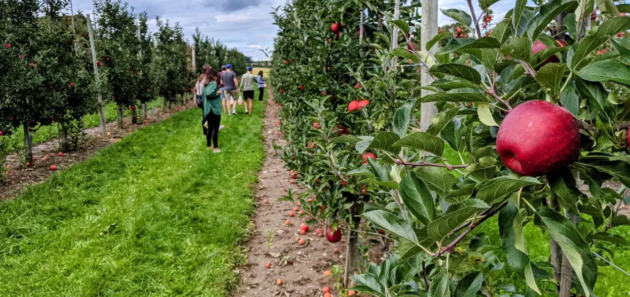
You may have noticed the large number of orchards we drive past when we go North of the city. Come fall, the apple trees are heavy with fruit and picking your own apples is a great way of feeling more connected to the land and the food we eat.
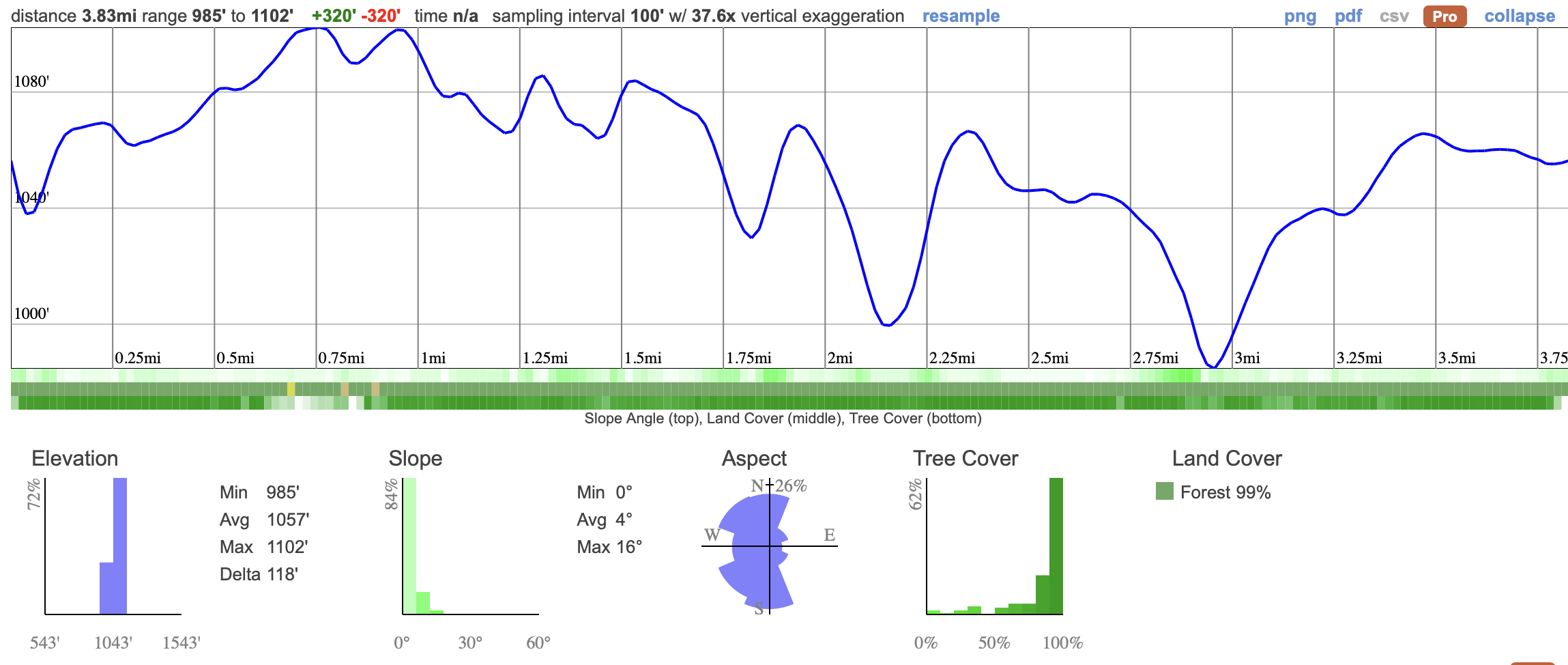
We'll kick off the day with a 6km easy hike around a little known forest, just 70km North of Toronto. This will be a pretty hike with ponds along the way and a little different to some of our usual spots because of the sandy trails.
The cost of this trip includes admission to the orchard and a 5lb bag of apples for you to take home!
This 10 km hike is an easy walk through peaceful forest on mostly flat dirt and sandy trails. With time for breaks and a bit of exploring along the way, it usually takes about 4 hours to complete. The route is gentle and beginner friendly, making it a relaxed way to enjoy the woods without much climbing.
08:50 - Those leaving from Keele meet at the PetroCanada by Keele Station
09:00: Shuttle leaves from PetroCanada at Keele Station. Please note that we leave dead on 9am and can't wait for latecomers.
10:15 - 13:30 - Meet self-drivers at the Eldred King Woodlands trail head and begin Hike. Self-drivers - please note that you will need to be at the trail head on time, it's recommended that you arrive a few minutes early so you don't miss the group.
Depending on how long the hike takes, you can either eat lunch during the hike or once you've got to the Orchard.
14:00 - 15:30 - Orchard visit to Organics Farm.
17:00 - Anticipated return to Toronto - N.B drop off will exclusively be at Keele Station.
This custom map is georeferenced, meaning it will show you where you are on the map in the right software and lays out the rough path that we’ll be following. It’s opened with the Avenza app which must be downloaded and installed in advance of the adventure.
You should also download the What3words app - this makes it easy to share and find locations in the unlikely event that you get lost.
Keep an eye on how the weather is developing. If it looks like it'll be raining, make sure you're dressed appropriately.
Packing list
Have any questions? Ask us on the Discord!
Grab breakfast before you go. There's a Tims around the corner from our meet-up point.
Bring a packed lunch, snacks and at least a 2 litres of water for the hike. We also reccomend electolyte drinks for hot days!
You should read all of the instructions in here carefully and make sure you've downloaded and installed the map! It's important that you listen to the guides and follow their instructions at all times.
Heat Exhaustion/Sun Exposure - Follow these steps to protect yourself:
Hiking injuries: Wear appropriate footwear (ankle high hiking boots) and hike within your abilities. If you need extra support, bring hiking poles.
Getting lost: All hikers must remain with the group at all times. If you do find yourself lost at any point, stay where you are and call for help. If you have a whistle, bring it.
Trail conditions: Trails may be muddy, ensure you're wearing proper footwear with tread and ankle support.
Horses and Mountain Bikes on the trail - Look out and give room to other trail users.
Ticks - Tick season has started again and they're active in the area we're visiting. Black Legged Ticks have the risk of carrying Lyme disease so it's important that you check yourself thoroughly after each hike. You're also recommended to have your legs covered so it's harder for them to latch on.
<iframe src="https://www.google.com/maps/embed?pb=!1m18!1m12!1m3!1d17126.77885591699!2d-79.79182025556538!3d44.92608011154032!2m3!1f0!2f0!3f0!3m2!1i1024!2i768!4f13.1!3m3!1m2!1s0x4d2aefc5ad3ec237%3A0xeb15c1e63bd227d3!2sMcCrae%20Lake%20Parking!5e0!3m2!1sen!2sca!4v1706702644904!5m2!1sen!2sca" width="400" height="300" style="border:0;" allowfullscreen="" loading="lazy" referrerpolicy="no-referrer-when-downgrade"></iframe>
We like to share some of the indigenous background of the areas we visit because these territories have rich histories that are easy to overlook. Indigenous communities have a connection to and respect for the land that has largely been lost since European settlement. As we strive to form a deeper connection with the land, we have much to learn from these communities. I use the Native Land map to learn more about these areas and find that developing a richer understanding leads to a greater enjoyment of the adventures.
Nations who still have connections to the area are the Missisaugas of the Credit First Nation the Huron Wendat, the Anishnabe and Haudenosaunee.
You may have noticed the large number of orchards we drive past when we go North of the city. Come fall, the apple trees are heavy with fruit and picking your own apples is a great way of feeling more connected to the land and the food we eat.
We'll kick off the day with a 6km easy hike around a little known forest, just 70km North of Toronto. This will be a pretty hike with ponds along the way and a little different to some of our usual spots because of the sandy trails.
The cost of this trip includes admission to the orchard and a 5lb bag of apples for you to take home!
This 10 km hike is an easy walk through peaceful forest on mostly flat dirt and sandy trails. With time for breaks and a bit of exploring along the way, it usually takes about 4 hours to complete. The route is gentle and beginner friendly, making it a relaxed way to enjoy the woods without much climbing.
08:50 - Those leaving from Keele meet at the PetroCanada by Keele Station
09:00: Shuttle leaves from PetroCanada at Keele Station. Please note that we leave dead on 9am and can't wait for latecomers.
10:15 - 13:30 - Meet self-drivers at the Eldred King Woodlands trail head and begin Hike. Self-drivers - please note that you will need to be at the trail head on time, it's recommended that you arrive a few minutes early so you don't miss the group.
Depending on how long the hike takes, you can either eat lunch during the hike or once you've got to the Orchard.
14:00 - 15:30 - Orchard visit to Organics Farm.
17:00 - Anticipated return to Toronto - N.B drop off will exclusively be at Keele Station.
This custom map is georeferenced, meaning it will show you where you are on the map in the right software and lays out the rough path that we’ll be following. It’s opened with the Avenza app which must be downloaded and installed in advance of the adventure.
You should also download the What3words app - this makes it easy to share and find locations in the unlikely event that you get lost.
Keep an eye on how the weather is developing. If it looks like it'll be raining, make sure you're dressed appropriately.
Packing list
Have any questions? Ask us on the Discord!
Grab breakfast before you go. There's a Tims around the corner from our meet-up point.
Bring a packed lunch, snacks and at least a 2 litres of water for the hike. We also reccomend electolyte drinks for hot days!
You should read all of the instructions in here carefully and make sure you've downloaded and installed the map! It's important that you listen to the guides and follow their instructions at all times.
Heat Exhaustion/Sun Exposure - Follow these steps to protect yourself:
Hiking injuries: Wear appropriate footwear (ankle high hiking boots) and hike within your abilities. If you need extra support, bring hiking poles.
Getting lost: All hikers must remain with the group at all times. If you do find yourself lost at any point, stay where you are and call for help. If you have a whistle, bring it.
Trail conditions: Trails may be muddy, ensure you're wearing proper footwear with tread and ankle support.
Horses and Mountain Bikes on the trail - Look out and give room to other trail users.
Ticks - Tick season has started again and they're active in the area we're visiting. Black Legged Ticks have the risk of carrying Lyme disease so it's important that you check yourself thoroughly after each hike. You're also recommended to have your legs covered so it's harder for them to latch on.
<iframe src="https://www.google.com/maps/embed?pb=!1m18!1m12!1m3!1d17126.77885591699!2d-79.79182025556538!3d44.92608011154032!2m3!1f0!2f0!3f0!3m2!1i1024!2i768!4f13.1!3m3!1m2!1s0x4d2aefc5ad3ec237%3A0xeb15c1e63bd227d3!2sMcCrae%20Lake%20Parking!5e0!3m2!1sen!2sca!4v1706702644904!5m2!1sen!2sca" width="400" height="300" style="border:0;" allowfullscreen="" loading="lazy" referrerpolicy="no-referrer-when-downgrade"></iframe>
We like to share some of the indigenous background of the areas we visit because these territories have rich histories that are easy to overlook. Indigenous communities have a connection to and respect for the land that has largely been lost since European settlement. As we strive to form a deeper connection with the land, we have much to learn from these communities. I use the Native Land map to learn more about these areas and find that developing a richer understanding leads to a greater enjoyment of the adventures.
Nations who still have connections to the area are the Missisaugas of the Credit First Nation the Huron Wendat, the Anishnabe and Haudenosaunee.