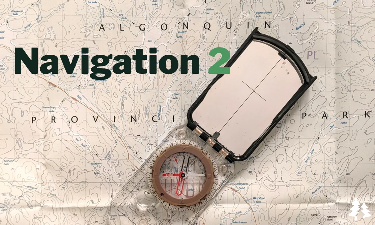
After learning the basics of navigation last week, we’ll be putting our skills to the test with a real world navigation exercise. You’ll get a set of grid references and will have to navigate around them using nothing but your new knowledge, a map and a compass.
We’ll be breaking into separate groups, each following a different course as you make your way through dense forest. The exercise takes place in a controlled environment and we’ll have numerous safety measures in place to prevent anyone from actually getting lost!
We’re visiting Awenda Provincial Park for this adventure, a lesser know but beautiful park just under 2hrs away from the city.
The hike isn’t too technically challenging and we won’t be hiking a great distance but you will be walking through the bush and it is therefore likely to be slow going.
We’ll give each group a map at the beginning of the exercise that you’ll use to find your way around the designated grid references.
08:20 - Meet at the Petro Canada gas station next to Keele Subway if you’re getting a lift. (There’s a Tim’s round the corner if you want to grab coffee/food). There’s ample parking on Keele.
08:30 - Van leaves. We can’t wait for latecomers so don’t be late!
08:40 - Pick up Anant and friends at Red & White Sharma at 1635 Lawrence avenue
08:55- Collect Jaime and Krishna at HWY400/7 carpool lot
10:30: Arrive at Awenda PP, meeting at the parking near the Administration Office. Self drivers please note that you’ll need to purchase a day use permit on arrival.
10:30-12:00 - Exercise briefing, route card planning
12:30-15:00 - Navigation exercise
15:30-16:30 - Debrief & visit beach
18:30 - Expected return to Keele Station
This custom map is georeferenced, meaning it will show you where you are on the map in the right software and lays out the rough path that we’ll be following. It’s opened with the Avenza app which must be downloaded and installed in advance of the adventure.
You should also download the What3words app - this makes it easy to share and find locations in the unlikely event that you get lost.
Pack layered clothing and a rain coat just in case. It could get chilly.
- Compass (if you have your own)
- Whistle (if you have your own) for signalling
It's likely to be muddy so hiking boots are strongly recommended.
Bring a packed lunch, at least 1l of water and snacks.
Maps, compasses, radios will all be provided.
Self-drivers may want to purchase a full day daily vehicle permit in advance. Alternatively, you can do so on-site.
Hiking injuries - Wear appropriate footwear (ankle high hiking boots) and hike within your abilities.
Getting lost - You may not have reception at times so we'll be providing you with a radio. If you think you may be lost, blow on a whistle 3 times for help to help us locate you if you don't have reception. You should also download the What3Words app to be able to easily share your location. It is important that you stay with your own navigation group at all times and do not get separated.
Ticks - Tick season has started again and they're active in the area we're visiting. Black Legged Ticks have the risk of carrying Lyme disease so it's important that you check yourself thoroughly after each hike. You're also recommended to have your legs covered so it's harder for them to latch on. Learn about checking for ticks here.
Awenda Provincial Park is located on the shores of Georgian Bay in Ontario, Canada, and has a rich indigenous history. The area has been inhabited by indigenous people for thousands of years and has served as a vital resource for food, medicine, and trade. The indigenous communities that have lived in the area include the Wendat (Huron), Anishinaabe (Ojibwe), and Haudenosaunee (Iroquois) peoples.
The Wendat people, who are known for their agriculture, settled in the area around the 15th century and established villages near the park. They hunted, fished, and gathered plants in the surrounding forests and wetlands.
The Anishinaabe people also lived in the area and had a close relationship with the land. They believed that all things in nature were interconnected and that it was their responsibility to care for the environment. They hunted, fished, and gathered wild rice, berries, and other plants.
The Haudenosaunee people, who were primarily located to the south, used the park area for hunting and gathering. They also used the nearby waterways for trade and transportation.
Today, the indigenous communities in the area continue to have a strong connection to the land and use it for traditional activities such as hunting, fishing, and gathering.
After learning the basics of navigation last week, we’ll be putting our skills to the test with a real world navigation exercise. You’ll get a set of grid references and will have to navigate around them using nothing but your new knowledge, a map and a compass.
We’ll be breaking into separate groups, each following a different course as you make your way through dense forest. The exercise takes place in a controlled environment and we’ll have numerous safety measures in place to prevent anyone from actually getting lost!
We’re visiting Awenda Provincial Park for this adventure, a lesser know but beautiful park just under 2hrs away from the city.
The hike isn’t too technically challenging and we won’t be hiking a great distance but you will be walking through the bush and it is therefore likely to be slow going.
We’ll give each group a map at the beginning of the exercise that you’ll use to find your way around the designated grid references.
08:20 - Meet at the Petro Canada gas station next to Keele Subway if you’re getting a lift. (There’s a Tim’s round the corner if you want to grab coffee/food). There’s ample parking on Keele.
08:30 - Van leaves. We can’t wait for latecomers so don’t be late!
08:40 - Pick up Anant and friends at Red & White Sharma at 1635 Lawrence avenue
08:55- Collect Jaime and Krishna at HWY400/7 carpool lot
10:30: Arrive at Awenda PP, meeting at the parking near the Administration Office. Self drivers please note that you’ll need to purchase a day use permit on arrival.
10:30-12:00 - Exercise briefing, route card planning
12:30-15:00 - Navigation exercise
15:30-16:30 - Debrief & visit beach
18:30 - Expected return to Keele Station
This custom map is georeferenced, meaning it will show you where you are on the map in the right software and lays out the rough path that we’ll be following. It’s opened with the Avenza app which must be downloaded and installed in advance of the adventure.
You should also download the What3words app - this makes it easy to share and find locations in the unlikely event that you get lost.
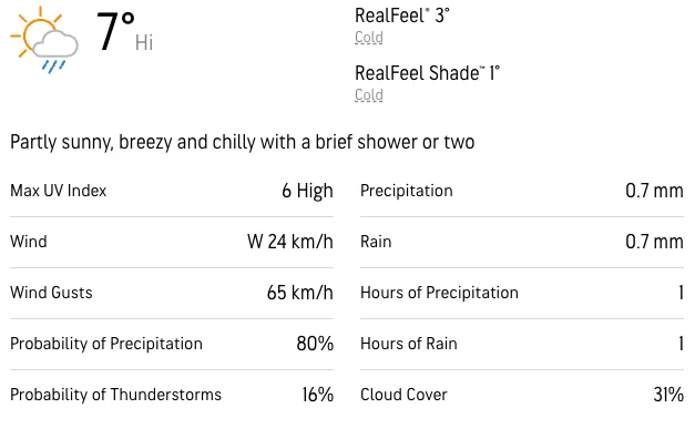
Pack layered clothing and a rain coat just in case. It could get chilly.
- Compass (if you have your own)
- Whistle (if you have your own) for signalling
It's likely to be muddy so hiking boots are strongly recommended.
Bring a packed lunch, at least 1l of water and snacks.
Maps, compasses, radios will all be provided.
Self-drivers may want to purchase a full day daily vehicle permit in advance. Alternatively, you can do so on-site.
Hiking injuries - Wear appropriate footwear (ankle high hiking boots) and hike within your abilities.
Getting lost - You may not have reception at times so we'll be providing you with a radio. If you think you may be lost, blow on a whistle 3 times for help to help us locate you if you don't have reception. You should also download the What3Words app to be able to easily share your location. It is important that you stay with your own navigation group at all times and do not get separated.
Ticks - Tick season has started again and they're active in the area we're visiting. Black Legged Ticks have the risk of carrying Lyme disease so it's important that you check yourself thoroughly after each hike. You're also recommended to have your legs covered so it's harder for them to latch on. Learn about checking for ticks here.
Awenda Provincial Park is located on the shores of Georgian Bay in Ontario, Canada, and has a rich indigenous history. The area has been inhabited by indigenous people for thousands of years and has served as a vital resource for food, medicine, and trade. The indigenous communities that have lived in the area include the Wendat (Huron), Anishinaabe (Ojibwe), and Haudenosaunee (Iroquois) peoples.
The Wendat people, who are known for their agriculture, settled in the area around the 15th century and established villages near the park. They hunted, fished, and gathered plants in the surrounding forests and wetlands.
The Anishinaabe people also lived in the area and had a close relationship with the land. They believed that all things in nature were interconnected and that it was their responsibility to care for the environment. They hunted, fished, and gathered wild rice, berries, and other plants.
The Haudenosaunee people, who were primarily located to the south, used the park area for hunting and gathering. They also used the nearby waterways for trade and transportation.
Today, the indigenous communities in the area continue to have a strong connection to the land and use it for traditional activities such as hunting, fishing, and gathering.