.webp)
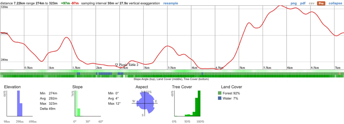
We're visiting the Bracebridge Resource Management Centre to hike some of the most spectacular scenery that Muskoka has to offer. We're starting this adventure with an easy 7km hike that traces the gorgeous Muskoka river, along pine-fringed shores and easy trails through dense forest. We'll stop for lunch along the river and have a chance to switch off from the worries of the city and take in some incredibly peaceful views.
We'll then move on to a nearby waterfall, one of the most impressive in the area that has a calm pool at the bottom where those who want to can swim. Summer days don't get any better than this!
This hike is in one of Wilderness Union's secret locations that we don't share publicly. Our secret locations are places you won't have visited before and are typically super quiet as the secret hasn't yet got out.
This will be a relatively easy hike through a very beautiful part of muskoka. The 7.2km should take about 3.5 hours total.
07:50 - Meet at PetroCanada next to Keele Subway Station. There's free parking on Keele Street north of the station. Make sure you've had breakfast and used the washroom before meeting us!
08:00 - Van leaves. Please note that we'll be leaving dead on time and can't wait for latecomers so please, please be on time!
10:00 - Meet up with Self Drivers at Bracebridge Resource Management Centre. Please be on time - we won't be able to wait for you!
10:00 - 13:15 - Hike, eating lunch en route
13:15 - Drive to High Falls
13:30 - 15:00 - Hike around the area, swim in the water if safe to do so.
18:00 - Rough arrival time back at Keele Station
This custom map is georeferenced, meaning it will show you where you are on the map in the right software and lays out the rough path that we’ll be following. It’s opened with the Avenza app which must be downloaded and installed in advance of the adventure.
You should also download the What3words app - this makes it easy to share and find locations in the unlikely event that you get lost.
Bring a packed lunch, snacks and plenty of water.
Ticks - Black legged ticks are in the area. You should wear pants rather than shorts to prevent them latching on and lighter colours make it easier to spot them and keep you more cool. There's no need to worry about ticks if we take a few precautions and we'll talk about doing a tick check after the hike just to confirm we haven't picked any up. You can learn more here
Getting lost - Please stick with the group at all times and follow their instructions.
Heat stroke - It could be very hot so it's important you cover up appropriately and ensure that you're drinking plenty of water.
Hiking injuries - Wear appropriate footwear and hike within your abilities. If you need extra support, bring hiking poles. Any injuries? Let us know in advance of the hike.
Water danger - Stay away from fast moving water and only swim where guides have explicitly said is safe. Swimming is only allowed under supervision and if you can't swim, you should keep out of the water.
We like to share some of the indigenous background of the areas we visit because these territories have rich histories that are easy to overlook. Indigenous communities have a connection to and respect for the land that has largely been lost since European settlement. As we strive to form a deeper connection with the land, we have much to learn from these communities. I use the Native Land map to learn more about these areas and find that developing a richer understanding leads to a greater enjoyment of the adventures.
Bracebridge and the surrounding area is on the traditional territory of the Anishnaabe and Missisaugas.